News and Information
The Maine Geological Survey is pleased to announce the release of a new bedrock map, Bedrock Geology of the West Rockport quadrangle, Maine, by Henry Berry (MGS geologist), Philip Osberg, and Andrew Fagenholz. A companion to the Camden quadrangle released earlier this year, the West Rockport quadrangle covers inland areas of Camden, Hope, and Union along Route 17 and northern parts of Warren and Rockland along Route 90 including Bald, Ragged, and Spruce mountains, several small lakes, and the headwaters of the Oyster River. The map shows that the Megunticook and Penobscot formations can be traced to the west from the Camden Hills area, although it is a complicated pattern due to the deformation of the earth’s crust during continental collision in Silurian-Devonian time. Offset along an ancient fault explains the presence of different rock units in the southeastern part of the map, such as the Benner Hill Formation in its type area on Benner Hill, and a series of rocks described for the first time as the Oyster River Gneiss. Small marble occurrences and a historic metallic mineral prospect are shown on the map as well as abundant structural data.
Bedrock maps provide a basic information source that can contribute to understanding groundwater quality, groundwater flow and contaminant transport, soil chemistry, distribution of mineral resources, engineering properties relevant to construction projects, and the history of the earth.
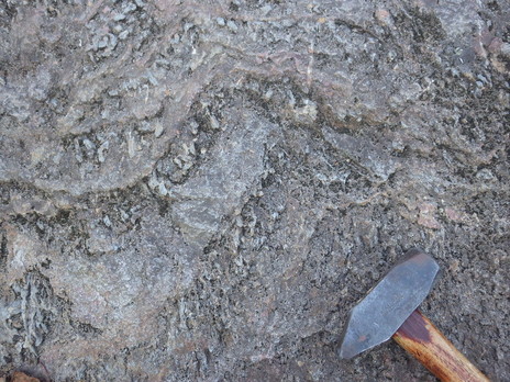
Megunticook Formation on Bald Mountain, Camden. Gray lumps are the metamorphic mineral sillimanite. Maine Geological Survey photo.
For a geologic field guide to a site in this quadrangle, see Glimpses of Geologic History along the Bald Mountain Trail, Camden, Maine.
|