Plants
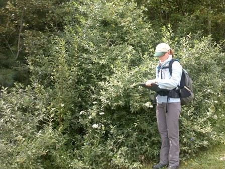
Surveying several large, invasive autumn olive shrubs at the edge of a field. Photo courtesy of the Maine Department of Agriculture, Conservation and Forestry.
Farm and woodland owners and operators in five Maine counties may be eligible to receive a free invasive plant survey and management plan, prepared by a natural resource professional from the local Soil and Water Conservation District (SWCD). Staff of SWCDs serving Kennebec, Knox, Lincoln, Somerset, and Waldo counties are looking for landowners or operators who would like to learn more about the invasive plants on their farms and woodlands.
Impacts of invasive plants: Invasive plants like Asiatic bittersweet vines, thorny multiflora rose shrubs, sprawling Japanese barberry, and others can create dense tangles in forests, wetlands, and fields, crowding out native plants and young trees. Along forest edges and hedgerows, thickets of invasive shrubs can reduce the area of productive fields. Some invasive plants create habitat for ticks, cause skin rashes, or are harmful if eaten by livestock.
Identify harmful plants and get guidance on management: Many farmers and woodland owners know that invasive plants are present but aren’t sure what to do about them. Others may not know how to recognize invasive plants. Having a site visit and survey from the local SWCD is a chance to talk with a natural resource professional, learn to identify harmful plants, and get guidance on how to manage them. Survey data also help scientists understand invasive plant distribution in Maine because data are contributed to the online mapping tool iMapInvasives, the central repository for invasive plant data in Maine.
Free thanks to funders: This service is free to farm and woodland owners or operators thanks to a grant from the United States Department of Agriculture – Natural Resources Conservation Service (USDA NRCS) administered by the Maine Natural Areas Program in the Maine Department of Agriculture, Conservation and Forestry. The project is also funded in part by the Maine Outdoor Heritage Fund, in which proceeds from the sale of a dedicated instant lottery ticket are used to support outdoor recreation and natural resource conservation. Space is limited and landowners/operators must meet basic USDA – NRCS eligibility requirements. Site visits will be conducted during the growing season, but sign ups are open now.
Management assistance: Participating landowners and operators are encouraged to act on the management plans they receive by implementing invasive plant treatments. Treatment funding may be available by applying to the USDA NRCS Environmental Quality Incentives Program through the local USDA NRCS office.
To learn more and sign up for a free survey and management plan, please contact the SWCD in the county where the farm or woodland is located:
Flyer available: A colorful flyer about the project is available from the Maine Natural Areas Program website. Please share widely.
 A project staff member surveys a large patch of invasive garlic mustard in Sidney. Photo courtesy of the Maine Department of Agriculture, Conservation and Forestry.
|