News and Information
The Maine Geological Survey (MGS) is pleased to announce the publication of two new geologic maps for Maine.
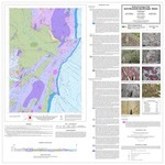
The Bedrock geology of the Jack Mountain quadrangle, Maine by Professor Chuzeng Wang of the University of Maine at Presque Isle, was released in October. This map continues Professor Wang's mapping in north central Maine along the Munsungan Anticlinorium. This area was mapped last during the 1970's but only at a reconnaissance level of 1:250,000. There are known economic mineral deposits in the region and the chert deposits, used by Native Americans for stone tools, provide ample justification for more detailed mapping.
|
 |
|
The Bedrock geology of the Lisbon Falls South quadrangle, Maine by Professor David West of Middlebury College, is now available from MGS. This area includes important zones of migmatite and is near the regional Norumbega fault system. The bedrock has a direct impact on groundwater quality for 60% of the regions citizens. Mapping in this densely populated area of the state is helping resource managers make informed decisions about development. |
All Maine geology maps produced by MGS are a culmination of hundreds of hours of field investigations by staff and cooperating geologists. The data from the field work is compiled in the survey's database and geographic information system after each field season. Data from previous field work by other geologists or other historical publications may also be added. The geologist analyzes and interprets the data to create a draft digital map that represents the nature, three-dimensional relationships, and origin of the geologic materials in the area. These information systems are used to produce a draft digital map. This draft undergoes a number of cartographic, geologic and editorial reviews before it is ready to be released. The maps can be downloaded in PDF format from the links above or paper versions may be purchased from MGS.
|