News and Information
The Maine Geological Survey (MGS) is pleased to announce the publication of two new bedrock geologic maps for Maine.
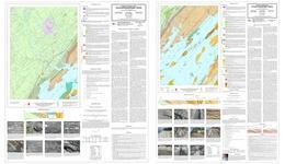
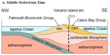 The elongated islands and peninsulas of northern Casco Bay are an eroded surface expression of an old, complex bedrock structure that is displayed in detail in these two new bedrock maps by Prof. David West (Middlebury College) and his late mentor Prof. Arthur Hussey (Bowdoin College, emeritus). Partially melted Silurian metamorphic rocks flank the inland side of the maps, against a variety of schists and gneisses of Ordovician age to the southeast, remnants of a volcanic island arc system. Folded patterns and several ancient faults have been recognized by the careful mapping of the distribution of various rock units. Cross-sections, photos, and extensive descriptions elucidate the rich geologic history of this area. These modern maps significantly update the previous hand-drawn maps of this area by Prof. Hussey of the 1980's.
|
All Maine geology maps produced by MGS are a culmination of hundreds of hours of field investigations by staff and cooperating geologists. The data from the field work is compiled in the survey's database and geographic information system after each field season. Data from previous field work by other geologists or other historical publications may also be added. The geologist analyzes and interprets the data to create a draft digital map that represents the nature, three-dimensional relationships, and origin of the geologic materials in the area. These information systems are used to produce a draft digital map. This draft undergoes a number of cartographic, geologic and editorial reviews before it is ready to be released. The maps can be downloaded in PDF format from the links above or paper versions may be purchased from MGS.
|