News and Information
Just in time for last minute Christmas shopping, the Maine Geological Survey (MGS) is pleased to announce the publication of nine new geologic maps for Maine. The last couple of months have brought maps to completion after many years of field work, cartography, and geologic editing by MGS staff and collaborators.
The recent publication of the bedrock geologic map for Brooks East (Stephen G. Pollock) and a reissue of the Brooks West (David P. West, Jr.) bedrock geologic map highlight the importance of the Ray Corner Mylonite Suite. Mylonite is a term used to describe the appearance of a rock that has been stretched and smeared under pressure and high temperatures. These mylonites occur in a large regional feature called the Norumbega Shear Zone, which is interpreted to represent an ancient fault system once buried deep in the earth and now exposed at the surface. Bedrock mappers Pollock and West found that the Ray Corner Mylonite Suite contains networks of pseudotachylyte, a glass-like material formed by flash melting and quick freezing of rock, possibly during an earthquake. A recent study by Rowe and others in the Journal of Geophysical Research: Solid Earth (2018, volume 123: https://doi.org/10.1029/2018JB016192) used the fossil earthquake slip surfaces defined by the pseudotachylytes to learn more about what happens during earthquakes we experience today.
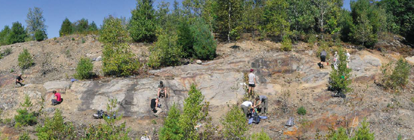 Figure 2 from Rowe and others, 2018.
 |
MGS Geologist Lindsay Spigel spent the summer 2018 field season working in the Mount Blue and East Dixfield quadrangles to identify the features, materials, and landforms shaped by the last period of glaciation in Maine. Stony till and boulders are abundant in the rolling hills of the East Dixfield and Mount Blue quadrangles, but useful sand and gravel can be found in scattered areas of ice-contact and glacial outwash deposits. Hikes in Mount Blue State Park and up to Bald Mountain offer many great examples of glacial materials and how glaciers sculpted the landscape, as well as fabulous scenery.
The following maps of the area are now available:
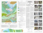 Whenever possible MGS assists with developing the next generation of field geologists. Professor Dykstra Eusden at Bates College mapped the Bedrock geology of the Gilead quadrangle with a number of geology students over three summer field seasons. They've produced a rich map with cross-sections, many photos, and detailed descriptions of the complicated geology of a portion of Maine's western mountains.
|
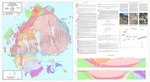
 Professor Allan Ludman of Queens College, New York, has been mapping bedrock geology in Maine for more than 50 years. He has extensive experience in east central Maine. The Greenfield bedrock map is a preliminary map product released by MGS to support a recent publication in Atlantic Geology (2018, volume 54: DOI: https://doi.org/10.4138/atlgeol.2018.012). This study utilizes radiometric ages of tiny grains of a durable mineral called zircon that were carefully separated from rock samples taken around eastern and central Maine, including rock units mapped in the Greenfield quadrangle. The ages of these mineral grains help geologists figure out the story of how different rocks in Maine were created or pieced together by moving tectonic plates millions of years ago. Revisions to the map are planned in the coming years as he completes the field work.
|
All Maine geology maps produced by MGS are a culmination of hundreds of hours of field investigations by staff and cooperating geologists. The data from the field work is compiled in the survey's database and geographic information system after each field season. Data from previous field work by other geologists or other historical publications may also be added. The geologist analyzes and interprets the data to create a draft digital map that represents the nature, three-dimensional relationships, and origin of the geologic materials in the area. These information systems are used to produce a draft digital map. This draft undergoes a number of cartographic, geologic and editorial reviews before it is ready to be released. The maps can be downloaded in PDF format from the links above or paper versions may be purchased from MGS.
|