News and Information
The Maine
Geological Survey (MGS) is pleased to announce the publication of three new
geologic maps for Maine.
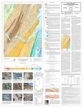
 Surficial geology of the Dixfield quadrangle, Maine: This is the first detailed surficial geology map of this area ever produced. MGS Geologist Lindsay Spigel spent the summer 2017 field season working to identify the features and landforms in the quadrangle shaped by the last glaciation of Maine.
|
All Maine geology maps produced by MGS are a culmination of many hours of field investigations by staff and cooperating geologists. The data from the field work is collected in the survey's database and geographic information system after each field season. Data from previous field work by other geologists or other historical publications may also be added. The
geologist analyzes and interprets the data to create a draft digital map that represents
the nature, three-dimensional relationships, and origin of the geologic
materials in the area. These systems are used to produce a draft digital map. This draft undergoes a number of cartographic, geologic and editorial reviews before it is ready to be released. The maps can be downloaded in PDF format from the links above or folded paper versions may be purchased from MGS.
 |
|
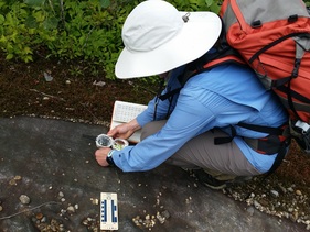
MGS Geologist Lindsay Spigel collecting glacial
striation orientation data in the Dixfield quadrangle, July 2017. |
If you have any questions about the mapping program please contact the Maine Geological Survey.
|