Moving New Orleans Bikes Releases New Orleans Bikeway Blueprint Digital Map, Executive Summary
NEW ORLEANS — Mayor LaToya Cantrell today released the New Orleans Bikeway Blueprint, which lays out the plan to transform neighborhoods into multi-modal communities where people and places are connected by bicycle, car, pedestrian and transit networks.
“Since day one of this administration we have put equity at the front of our transportation work. We know that with 1 in 5 residents having no access to a car, they need more options to get around the city. That's why we're excited to finalize a plan to provide better bike facilities for our residents. Now more than ever, bicycle infrastructure is crucial to improving people’s access and mobility, and we're taking the steps to make that happen,” said Mayor Cantrell.
“Improving and expanding our biking infrastructure has long been a priority of mine, and now due to the pandemic, we’re seeing more people than ever using bikes for both work and recreation. We need to continue investing in protected lanes across the city and expand our network to accommodate clear desires from New Orleanians to bike more. If we are to continue moving forward as a more progressive city, it's critical to support this growth and direct more people away from cars and towards more sustainable transportation options,” said Kristin Gisleson Palmer, District C City Councilmember and Chair of the Transportation Committee.
[READ: New Orleans Bikeway Blueprint]
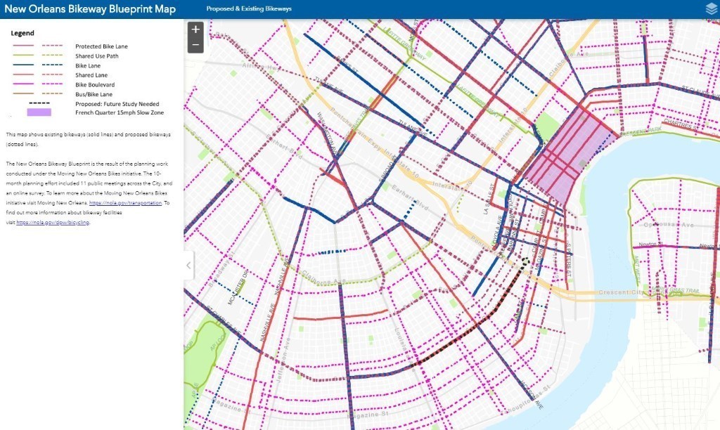
The Moving New Orleans Bikes Planning Project kicked off in 2019 and has officially concluded the Citywide Bike Planning effort. This planning project was made possible with support from People for Bikes in 2019, and is a collaborative effort between the Department of Public Works and the Mayor’s Office of Transportation. Read the executive summary here. See the map below.
“The digital version of the bikeway blueprint is a new and powerful tool for engaging and updating the community on our progress. New Orleans has come a long way in recent years and the digital blueprint provides a clear direction for future improvements,” said Jennifer Ruley, Mobility and Safety Lead for the Department of Public Works and manager of the Moving New Orleans Bikes project.
“Mayor Cantrell committed to rapidly expanding and improving the bikeway network by constructing 75 miles of new bike infrastructure in two years, and we are excited that the Department of Public Works is carrying out that initiative,” said Laura Bryan, Director, Mayor's Office of Transportation.
The construction component of the Moving New Orleans Bikes project kicked off in Algiers in late 2019, and is now expanding into the Central City, Lower Garden District, French Quarter, Faubourg Marigny, Central Business District, and Seventh Ward neighborhoods. Additional East Bank neighborhoods will be announced in the future.
Bicycle ridership has been increasing annually, with recent dramatic increases due to the onset of the COVID-19 pandemic. In the past several months, New Orleans has seen ridership on certain routes increase 158 percent, according to data collected by UNO Transportation Institute.
Any comments or questions about either the Blueprint can be sent to movingneworleans@nola.gov.
Learn more about Moving New Orleans Bikes by visiting the website here. Follow Moving New Orleans on Facebook and Instagram at @movingneworleans.
 # # #
|