|
 Having trouble viewing this email? View it as a Web page. Having trouble viewing this email? View it as a Web page.

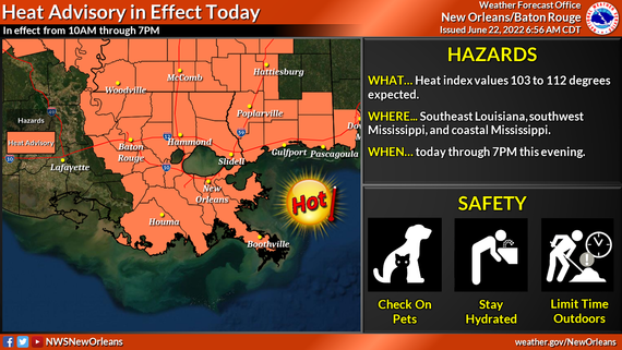
WHAT: Prolonged and Potentially dangerous heat conditions with heat index values of 103 to 112 today and 105 and maybe up to 115 Thursday through Saturday.
WHEN: Heat Advisory Today and additional advisories likely through Sunday even the possibility of an Excessive Heat Warning
WHERE: Southwest Mississippi, coastal Mississippi, and all of southeast Louisiana
The National Weather Service is confident hot temperatures and high humidity will occur each day and could quickly lead to heat illness if precautions aren’t taken.
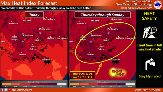
FORECAST:
· Heat index readings are expected to climb to, and likely above, 108 degrees for multiple hours today.
· Heat Index readings could exceed 113 degrees Thursday through Saturday and an Excessive Heat Warning may be needed for a few areas.
· The possibility of morning lows remaining in the upper 70s to possibly even lower 80s will provide little if any relief for the body to cool for those without access to air conditioning or cooling centers.
· In addition, densely populated urban areas like downtown New Orleans and downtown Baton Rogue where there is mostly cement, combined with a lack of any real breeze will lead to very oppressive conditions.
The graphics below highlight heat advisory and max forecasted Heat Index values
Helpful information pertaining to remaining safe during extreme heat events may be found at the following links:
Extreme Heat | Ready.gov
Extreme Heat | Ready.Gov | Be Safe During Extreme Heat
Extreme Heat | Ready.Gov | Heat Illness
Associated Content
|
