|
 Having trouble viewing this email? View it as a Web page. Having trouble viewing this email? View it as a Web page.
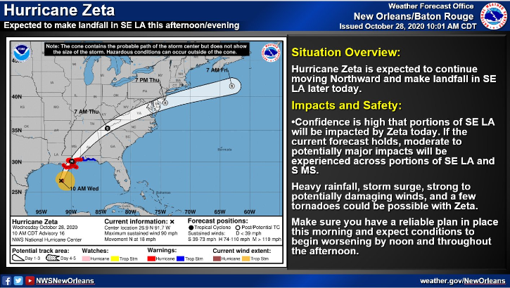
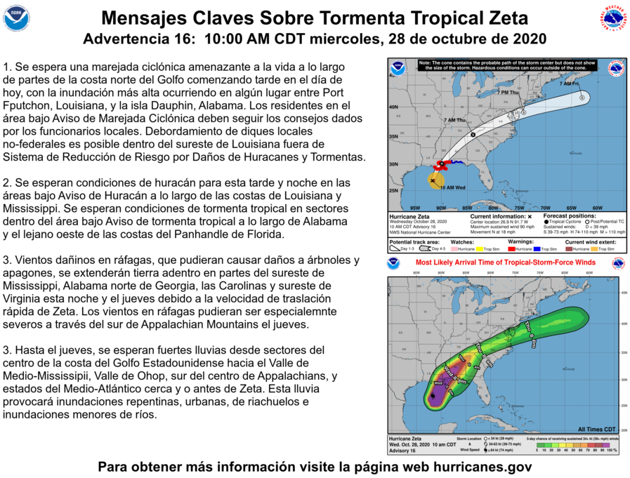
The National Hurricane Center Reports as of 1:00 PM CDT Wed Oct 28 2020 the
center of Zeta will make landfall in southeastern Louisiana this afternoon. Zeta will then move close to the Mississippi coast this evening, and move across the southeastern and eastern United States on Thursday.
POTENTIAL IMPACTS
-----------------
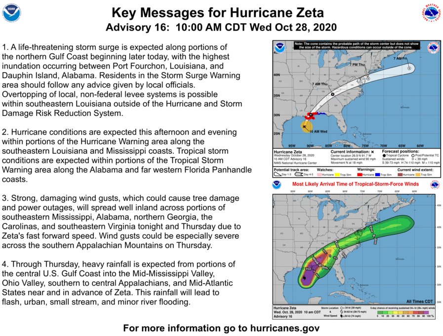
* WIND:
Protect against life-threatening wind having possible extensive impacts across extreme southeast Louisiana and southeast Mississippi.
Potential impacts in this area include:
- Considerable roof damage to sturdy buildings, with some having window, door, and garage door failures leading to structural damage. Mobile homes severely damaged, with some destroyed. Damage accentuated by airborne projectiles. Locations may be uninhabitable for weeks.
- Many large trees snapped or uprooted along with fences and roadway signs blown over.
- Some roads impassable from large debris, and more within urban or heavily wooded places. Several bridges, causeways, and access routes impassable.
- Large areas with power and communications outages.
Also, protect against dangerous wind having possible limited to significant impacts across east-central Louisiana and southwest Mississippi.
* FLOODING RAIN:
Protect against dangerous rainfall flooding having possible significant impacts across easternmost Louisiana and southeast Mississippi.
Potential impacts include:
- Moderate rainfall flooding may prompt several evacuations and rescues.
- Rivers and tributaries may quickly become swollen with swifter currents and overspill their banks in a few places, especially in usually vulnerable spots. Small streams, creeks, canals, and ditches overflow.
- Flood waters can enter some structures or weaken foundations.
Several places may experience expanded areas of rapid inundation at underpasses, low-lying spots, and poor drainage areas. Some streets and parking lots take on moving water as storm drains and retention ponds overflow. Driving conditions
become hazardous. Some road and bridge closures.
Protect against locally hazardous rainfall flooding having possible limited impacts across east-central Louisiana and southwest Mississippi.
* TORNADOES:
Protect against a tornado event having possible limited impacts across easternmost Louisiana and southeast Mississippi. Potential impacts include:
- The occurrence of isolated tornadoes can hinder the execution of emergency plans during tropical events.
- A few places may experience tornado damage, along with power and communications disruptions.
- Locations could realize roofs peeled off buildings, chimneys toppled, mobile homes pushed off foundations or overturned, large tree tops and branches snapped off, shallow-rooted trees knocked over, moving vehicles blown off roads, and small boats
pulled from moorings.
Elsewhere across Southeast Louisiana and South Mississippi, little to no impact is anticipated.
* OTHER PREPAREDNESS INFORMATION:
Now is the time to complete all preparations to protect life and property in accordance with your emergency plan. Ensure you are in a safe location before the onset of strong winds or possible flooding.
Failure to adequately shelter may result in serious injury or loss of life. Always heed the advice of local officials and comply with any orders that are issued. Remember, during the storm 9 1 1 Emergency Services may not be able to immediately respond if conditions are unsafe. This should be a big factor in your decision making.
It is important to remain calm, informed, and focused during an emergency. Be patient and helpful with those you encounter.
Rapidly rising flood waters are deadly. If you are in a flood-prone area, consider moving to higher ground.
Never drive through a flooded roadway. Remember, turn around don`t drown!
If a Tornado Warning is issued for your area, be ready to shelter quickly, preferably away from windows and in an interior room not prone to flooding.
If in a place that is vulnerable to high wind, such as near large trees, a manufactured home, upper floors of a high-rise building, or on a boat, consider moving to a safer shelter before the onset of strong winds or flooding.
Closely monitor local news & weather, City of Baker updates, weather.gov, NOAA Weather radio or local news outlets for official storm information. Be ready to adapt to possible changes to the forecast. Ensure you have multiple ways to receive weather warnings.
|
