|
 Having trouble viewing this email? View it as a Web page. Having trouble viewing this email? View it as a Web page.


Hurricane Delta Update
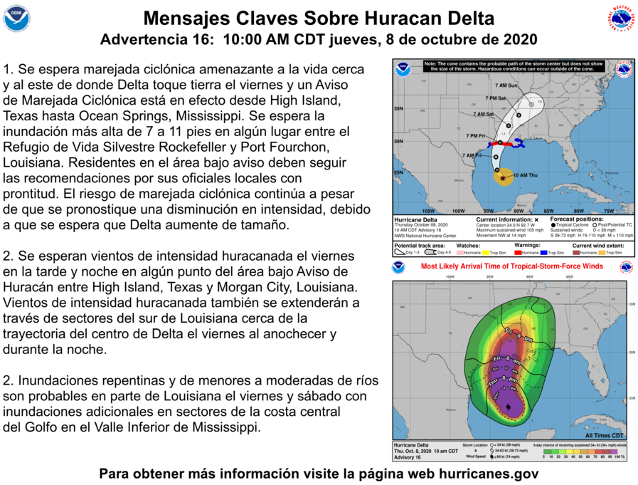
The National Weather Service has issued an update on Hurricane Delta. As of 10:00 AM CST: Delta is moving toward the northwest near 14 mph (22 km/h), and this motion with a reduction in forward speed is expected today. A turn toward the
north is forecast to occur by late tonight, followed by a north-northeastward motion by Friday afternoon or Friday night.
On the forecast track, the center of Delta will move over the central Gulf of Mexico today, over the northwestern Gulf of Mexico on Friday, and then move inland within the hurricane warning area Friday afternoon or Friday night.
Reports from NOAA and Air Force Reserve Hurricane Hunter aircraft indicate that maximum sustained winds have increased to near 105 mph (165 km/h) with higher gusts.
Additional strengthening is forecast, and Delta is expected to become a major hurricane again by tonight. Some weakening is possible as Delta approaches the
northern Gulf coast on Friday, with rapid weakening expected after the center moves inland.
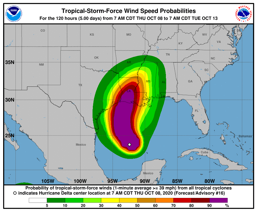
Hurricane-force winds extend outward up to 35 miles (55 km) from the center and tropical-storm-force winds extend outward up to 125 miles (205 km).
HAZARDS AFFECTING LAND:
WIND: Hurricane conditions are expected within the hurricane warning area by Friday afternoon or evening, with tropical storm conditions expected within this area by early Friday. Tropical storm conditions are expected within the tropical storm warning
areas on Friday, and are possible in the tropical storm watch area Friday night.
RAINFALL: Friday through Saturday, Delta is expected to produce 5 to 10 inches of rain, with isolated maximum totals of 15 inches, from southwest into south-central Louisiana. These rainfall amounts will lead to significant flash, urban, small stream flooding, along with minor to isolated moderate river flooding.
As with all tropical storms and hurricanes please be prepared for heavy rainfall, strong winds and strong wind gusts, and possible tornadoes.
Please ensure that you have your hurricane, storm and flood plans in place, be prepared and please stay up to date on weather forecasts.
The National Weather Service Forecast for Baker through Friday:
Today: A chance of showers, then showers and possibly a thunderstorm after noon. Steady temperature around 81. East wind 5 to 10 mph. Chance of precipitation is 90%. New rainfall amounts between a tenth and quarter of an inch, except higher amounts possible in thunderstorms.
Tonight: Showers likely and possibly a thunderstorm before 8pm, then a chance of showers and thunderstorms between 8pm and 11pm, then showers likely and possibly a thunderstorm after 11pm. Cloudy, with a low around 73. Northeast wind 5 to 10 mph. Chance of precipitation is 60%. New rainfall amounts between three quarters and one inch possible.
Friday: Tropical storm conditions possible. Showers and possibly a thunderstorm. High near 80. Chance of precipitation is 90%. New rainfall amounts between three quarters and one inch possible.
Friday Night: Tropical storm conditions expected. Showers and possibly a thunderstorm before 1am, then a chance of showers. Low around 71. Chance of precipitation is 90%.


|
