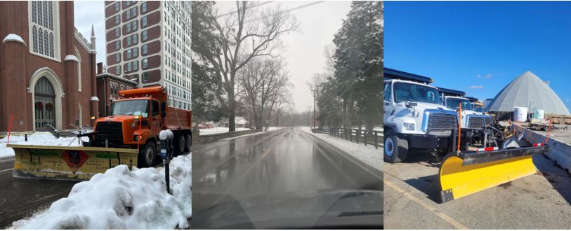
 A round of winter weather is expected to move into Louisville this weekend, January 22-25, bringing the potential for a wintry mix and accumulating snow. Louisville Metro’s Snow Team is fully prepared and will adjust operations as conditions evolve. Projections from the National Weather Service are shown here and are expected to continue to develop up until the storm arrives in our area.
Before a winter weather event, and when the conditions are right, Public Works treats roadways with brine, a liquid blend of salt and water, to help prevent snow and ice from bonding to the pavement, making plowing and salting more effective once precipitation begins. Residents may see the impacts of brining with white or gray lines on roadways ahead of a winter storm. This has been an effort that we have doubled down on this year because it gives crews the best head start to tackle the snow and/or ice before it has begun to accumulate. Residents can follow snow operations and track progress during a storm using the Snow Map at louisvilleky.gov/snow. The map shows which roads are included in Metro’s snow routes and when those routes were last treated or plowed.
As the storm develops, the Snow Team will treat roadways with salt and begin plowing. We encourage residents to stay off the road during major snow events, but if you must go out, please give yourself extra time to arrive at your destination and give snow trucks plenty of space on the roadway. Use extra caution on bridges and overpasses, which can freeze faster than other roadways. Review the emergency car kit essentials in the list in the section below.
Our team will be treating roadways around the clock until the event is over. For the latest snow response updates, follow Louisville Metro’s Snow Team on our social media channels (Facebook, Instagram, X) and visit the Snow Removal webpage throughout the winter season.
 When winter weather arrives, one of the most common questions we receive is: “When will my street be plowed?”
Louisville Metro’s Snow Map is the best resource for residents to check snow route coverage and monitor treatment progress during a storm.
What are snow routes?
Louisville Metro treats and plows only the roads included in our 111 officially designated snow routes. These routes are selected because they carry the highest traffic volumes, connect neighborhoods to major corridors, and provide access to hospitals, schools, emergency services, and major employers.
Neighborhood streets and private roads are not part of Louisville Metro’s snow routes, and interstates and ramps are maintained by the Kentucky Transportation Cabinet (KYTC).
If your street isn’t on a Metro snow route and you live within a suburban city or municipality in Jefferson County, snow removal may be handled by your local government. Residents should check with their city hall or public works department for specifics.
Residents whose streets are not included should also consider planning ahead with neighbors, homeowner associations, or property managers to manage local snow and ice removal.
How to use the Snow Map
The Snow Map helps residents see which Metro routes have been treated or plowed during an active snow event.
Here’s how to use it:
- Visit louisvilleky.gov/snow and select “Snow Map.”
- Type your address into the search bar to see whether your street is part of a Metro snow route.
- View treatment progress; the map shows when a roadway on a Metro route was last treated or plowed.
- Keep in mind that a road marked as “plowed” does not mean it is fully clear or dry — especially if snow continues to fall or temperatures remain below freezing.
The Snow Map helps residents understand where crews are working, which roads are included in Metro’s responsibilities, and how snow operations progress during a storm. It also helps drivers make more informed travel decisions during winter weather.
For storm updates and to access the Snow Map, visit louisvilleky.gov/snow
To report outages, please use the link below:
https://lge-ku.com/outages
If you must drive during a winter storm, stock your car with the essentials. A well-stocked kit can make a huge difference if you become stranded.
Consider including:
- Blanket or warm clothing
- Ice scraper and snow brush
- Flashlight with extra batteries
- Portable phone charger
- First-aid kit
- Bottled water and non-perishable snacks
- Jumper cables
- Small shovel
- Sand, cat litter, or traction mats
- Emergency flares or reflective triangles
- Gloves and hand warmers

Crews are making final preparations to ensure equipment is ready, with plans to begin operations Saturday morning
LOUISVILLE, Ky. (Jan. 23, 2026) – Snowfighters with the Kentucky Transportation Cabinet (KYTC) District 5, along with contract crews across all eight counties, are preparing for the arrival of a winter storm expected to impact the region beginning Saturday morning. District 5 covers Jefferson, Bullitt, Franklin, Oldham, Shelby, Spencer, Henry, and Trimble Counties.
Crews are completing final preparations to ensure equipment is ready, with plans to begin operations Saturday morning and work in rotating shifts to keep roadways passable. The National Weather Service (NWS) is forecasting 12 to 14 inches of snow across portions of the district, with a winter storm warning in effect. Crews will continue to closely monitor weather conditions and are prepared to plow snow and treat roads as the winter storm moves into the area.
KYTC maintains most roads, streets, and bridges that are part of the State Highway System, including interstates, parkways, and U.S. route designations (in Jefferson County, KYTC is only responsible for the interstates. KYTC operates on a four-tier priority system to keep people and commerce moving efficiently.
Road Safety and Preparation Tips for Kentuckians: Kentucky drivers are valuable partners in ensuring highway safety, especially during severe weather events. KYTC encourages Kentuckians to monitor forecasts, avoid unnecessary travel when possible, pack an emergency car kit and, if you must travel during the storm, check your route before you go at GoKY.ky.gov. For your safety, make sure to take it slow and know what to do if power lines are down or signals aren’t working.
Emergency Car Kit Suggested Items for Drivers:
- Extra coat, gloves, and blankets or sleeping bag
- Non-perishable food and water
- Baby formula, diapers, wipes
- Flashlight with extra batteries
- Pet food, water, leash, bowl
- Ice scraper and jumper cables
- Shovel, and a bag of sand or litter
What To Do if Traffic Signals Are Not Working:
- Flashing yellow, proceed with caution
- Flashing red, treat as a stop sign
- No signal lights, treat as a 4-way stop
What To Do When a Downed Power Line Is on the Roadway:
- Never touch or drive over a fallen power line; report the issue to the power company
- If a power line has fallen on your vehicle, STAY INSIDE, do not exit, and call 911
- Assume all downed power lines are live and DO NOT attempt to move
Visit snowky.ky.gov for snow and ice resources, like priority route maps, traffic cameras, tips and highway district updates.
 Louisville Water completed residual line pipeline installation on River Road in less than a year, well ahead of schedule. During the final phase of construction, workers will install valves in the new manholes and adjust final surfaces. This will involve temporarily closing one lane of River Road with the assistance of flaggers to direct traffic around these small work zones. The work will begin Monday, January 19 on River Road between Zorn Avenue and Transylvania Avenue.
This work is expected to last four weeks. To minimize traffic concerns, the lane closure will occur between 9:00 a.m. – 3:00 p.m. The work will NOT impact access to restaurants, parks, or residences, and no one will lose water service. When this work is completed, our contractor will return in the spring to complete restoration of unpaved areas and final cleanup efforts.
We greatly appreciate your patience and understanding as we work to complete this important project to provide high-quality drinking water.
 Project Webpage
Know someone who wants to receive this newsletter? Share this link.
 Tuesday, January 27, 2026, 1pm-4pm
Mellwood Art Center
(1860 Mellwood Ave., Van Gogh Building)
Free entry.
This B2B Expo features 50+ local businesses, reusable bags for the first 250 attendees, personalized “Quick Learns” and lots of prizes - all in a fun, festival atmosphere. Attendees can expect to go home with new connections and new tools for their business. Shifting our purchasing habits towards local, independent businesses can have big effects on our local economy, keeping more dollars circulating locally. This applies to both our personal AND business purchases. Make it your business to buy local! Produced by the Louisville Independent Business Alliance and presented by PrintWorx. You can find out more at KeepLouisvilleWeird.com/Expo.
 LOUISVILLE, Ky. (January 14, 2026) — Louisville Mayor Craig Greenberg and the Louisville Zoo invite the community to honor some of the Zoo’s most beloved residents at the Zoo’s first ever Birthday Bash on Saturday, January 24. This new event launches a monthly series of animal birthday celebrations that will continue throughout the year.
“Louisville is fortunate to have an amazing zoo with a wide variety of animals that call it home,” said Mayor Greenberg. “This new, fun-filled tradition is a great opportunity to celebrate our animal residents, adding to an already packed calendar of celebrations at the Louisville Zoo.”
Watch as these birthday stars enjoy species-specific custom enrichment treats designed just for them. Plus, guests can enjoy special keeper talks that reveal fascinating animal stories and care insights.
Birthday Bash Schedule (subject to change):
10:15 a.m. Siamang Darwin (23) Islands
10:30 a.m. Leopard Tortoises Esmerelda and Lavern (both 7) Giraffe bldg./Hyrax habitat
11 a.m. Western Lowland Gorilla Jelani (29) Gorilla Forest
11:15 a.m. Polar Bear Qannik (15, pronounced “KUN-ick”) Glacier Run
11:30 a.m. Hartmann’s Mountain Zebra Gibbs (19) Africa/Zebra
12:15 p.m. African Penguins Clyde (7) Islands
2 p.m. Linnaeus's two-toed sloth Fern (9) – keeper talk Sloth
2:15 p.m. Grey Seals Boone (22) and Rona (12) Glacier Run
The January Birthday Bash is free with Zoo admission. Plan your visit and see the full schedule at https://louisvillezoo.org/birthdaybash.
The Louisville Zoo will host its annual job fair in the Islands Pavilion Gheens Room on Saturday, January 24, 10:00AM - 2:00PM. The Zoo is seeking outgoing, highly motivated individuals who enjoy working with the public to fill seasonal positions in various departments.
Positions are available in admissions, animal departments, education, front desk, guest services, horticulture, membership and Splash Park. Candidates will receive training in their area. Animal and education departments require additional experience.
The compensation for seasonal positions starts at $16.65 per hour. All applicants must be at least 16 years of age and able to work a variable schedule that includes nights and weekends from March through November. Some positions require applicants to be 18 years of age and possess a valid driver’s license. For positions requiring CPR/First Aid Certification, the Zoo will provide training.
Seasonal positions in the Zoo’s animal departments require one year of college with a declared major in biology or a closely related field, as well as one year of working with animals in an institutional setting.
To apply for seasonal positions in the education department, candidates must have completed one year of college seeking a degree in elementary or secondary education, have one year of experience working with children in a formal or informal teaching setting (school, day camp, zoo or other cultural attraction), and have background knowledge of biology, ecology or related fields.
In addition to working in a unique environment, seasonal Zoo employees receive free Zoo admission and parking for the duration of their employment term as well as discounts in Zoo gift shops and food concession locations with Zoo ID.
The Zoo has full and part-time positions available in various areas. Visit louisvillezoo.org/hr for information on the positions and how to apply.
 |
| Jefferson County |
|
| I-65 Central Corridor |
Information related to the I-65 Central Corridor project can be found online at i65centralcorridor.com.
|
U.S. 31E (Main Street)
*Main Remade* |
*Construction phasing details, including traffic impacts, are available online at: www.MainRemade.com
Latest press release:
https://lnks.gd/2/33z8p--
|
| I-64 East and West |
Traffic Impacts: Traffic is in its final configuration. Lane closures are possible as final items as part of the project are underway.
Date/Time: Daily/nightly.
Project Limits: I-64 East and West at mile point 11.799, near Exit 10 (Cannons Lane) on I-64 West, and near Exit 12 to I-264 (Watterson Expressway) on I-64 East.
Type of Work: Bridge replacement project.
Other Details: *Project announcement press release
|
| I-65 South (John F. Kennedy Memorial Bridge) |
**Latest project update and details: https://lnks.gd/3/3RJ3qVj
-----------------------------------------------
Traffic Impacts: Closure of the right three lanes.
I-65 South (John F. Kennedy Memorial Bridge).
Type of Work: Expansion joint replacement project.
Other Details: The I-65 South to I-64 West ramp closure, which began Nov. 18, 2025, as part of the ongoing bridge expansion joint replacement project, will remain in place through January to support work on the southernmost expansion joint on the right side of the bridge. In addition to the ramp closure, the right three lanes and right shoulder of the Kennedy Bridge remain closed.
|
| I-264/U.S. 42 (Brownsboro Road) Improvement Project |
**Traffic impacts available here.**
|
| KY 841 North and South (Gene Snyder Freeway) |
Traffic Impacts: Single lane closures are possible.
Date/Time: Daily from 9 a.m. to 3 p.m., and nightly from 7 p.m. to 5 a.m.
Project Limits: KY 841 North and South (Gene Snyder Freeway), between mile point 35.0 and mile point 37.7, near and through the East End Tunnel.
Type of Work: Routine maintenance of the roadway and East End Tunnel.
Other Details: Motorists should heed signage, use caution, and adjust commutes to accommodate the lane closures. |
| KY 864 (Logan Street/Shelby Street) |
Traffic Impacts: Sidewalk and lane closures are possible.
Date/Time: Daily and nightly.
Project Limits: Between Goss Avenue and East Gray Street.
Type of Work: One-way to two-way conversion of the roadway.
Other Details: Major work has resumed, with full completion expected by Spring 2026.
*Project Webpage
|
| KY 1819 (Billtown Road) |
Traffic Impacts: Lane closures and delays are possible.
Date/Time: Daily – 9 a.m. to 4 p.m.
Project Limits: Three sections of KY 1819 (Billtown Road):
- Easum Road through Mary Dell Lane
- Michael Edward Drive through Fairground Road
- Shady Acres Lane through Colonnades Place
Type of Work: Reconstruction of KY 1819 (Billtown Road) from North of Colonnades Place to south of Easum Road with new traffic signals, signal optimization, turn lanes, storage lanes, etc. (varying by intersection based on existing conditions and future traffic projections).
Other Details: The reconstruction project is expected to be completed by the Spring of 2026.
*Project webpage
|
| KY 1932 (Chenoweth Lane) |
Traffic Impacts: Lane closures and delays are possible.
Date/Time: Daily and nightly.
Project Limits: KY 1932 (Chenoweth Lane) between U.S. 60 (Shelbyville Road) and U.S. 42 (Brownsboro Road).
Type of Work: Construction activities include roadway modifications, sidewalk and pedestrian crossing improvements, and drainage enhancements designed to reduce flooding and improve overall travel conditions in the area.
Other Details: This project is expected to be completed the Fall of 2026. |
I-264
*Various Exit Ramps |
Traffic Impacts: Ramp narrowing with intermittent lane and shoulder closures.
Project Limits: Various interchange Exit ramps on I-64 and I-264.
Type of Work: Installation and upgrade of wrong-way pavement markings and signs.
Other Details: The Highway Safety Improvement Project will install and enhance wrong-way signs and pavement markings on interstate Exit ramps to discourage wrong-way driving. Motorists should reduce speeds and obey traffic control while workers are present. This project is expected to be completed by the Fall of 2025. |
| |
|
| Bullitt County |
|
| KY 1526 (Bells Mill Road) |
Traffic Impacts: Road closure.
Date/Time: Beginning Monday, Nov. 17, through May 14, 2026.
Project Limits: KY 1526 (Bells Mill Road) will be closed at mile point 14.35 at the bridge over Floyds Fork.
Type of Work: Superstructure replacement.
Detour:
- For westbound traffic on KY 1526 (Bells Mill Road): Turn left onto KY 61 (Preston Highway) south toward Shepherdsville. At the signalized intersection, turn left onto KY 44 (East 4th Street) to reach KY 1526 (Bells Mill Road).
- For eastbound traffic on KY 1526 (Bells Mill Road): Turn right onto KY 44 (East 4th Street) through Shepherdsville. At the signalized intersection of KY 61 (Preston Highway), turn right to then reach KY 1526 (Bells Mill Road).
|
| |
|
| Franklin County |
|
| KY 12 (Flat Creek Road) |
Traffic Impacts: N/A.
Date/Time: Beginning Aug. 11, through the Fall of 2026.
Project Limits: KY 12 bridge over Flat Creek at mile point 12.46 (at the Franklin/Henry County line).
Type of Work: Bridge replacement project.
Other Details: Traffic will be maintained on the existing bridge until construction has been completed on the replacement bridge. |
| I-64 East and West |
Traffic Impacts: Lane closures and traffic shifts are possible.
Date/Time: Daily/nightly beginning Thursday, Sept. 4.
Project Limits: The I-64 East and West, between the Frankfort exits (mile markers 53 and 58).
Type of Work: The I-64 improvement project, between the Frankfort exits (mile markers 53 and 58), includes the milling and removal of the existing asphalt surface followed by resurfacing with new asphalt pavement. Other improvements to the 5-mile corridor include bridge repairs and bridge crash wall repairs.
Other Details:
- U.S. 60 (Versailles Road):
U.S. 60 (Versailles Road) will be reduced to one lane in each direction under the I-64 overpass bridge nightly from 9 p.m. to 6 a.m. beginning Monday, Sept. 15.
|
| U.S. 127/Vandalay Drive Intersection |
Traffic Impacts: Lane closures and traffic shifts are possible.
Date/Time: Daily/nightly.
Project Limits: U.S. 127/Vandalay Drive intersection.
Type of Work: The scope of the project includes constructing a new roundabout at the intersection of Vandalay Drive and Westridge Drive; extending Vandalay Drive to Limestone Drive to create a direct connection to KY 676 (East-West Connector); extending Vandalay Drive to U.S. 127 near the I-64/U.S. 127 interchange; and adding dual receiving lanes to improve left-turn movements from U.S. 127 onto Westridge Drive.
Other Details: The project is scheduled to be completed by the summer of 2026. |
| |
|
| Oldham County |
*Routine Maintenance* |
| |
|
| Spencer County |
*Routine maintenance* |
| |
|
| Shelby County |
|
| I-64 Widening and Improvement Project |
**Traffic impacts here.**
|
| |
|
| Henry County |
*Routine maintenance* |
| |
|
| Trimble County |
*Routine maintenance* |
| |
|
2025 Resurfacing Projects
Resurfacing projects will begin April 1, 2025, and
will be completed by the Fall of 2025.
Motorists should heed signage and use caution when traveling through the work zone.
| County / Road Name: |
Project Limits: |
| Jefferson County |
|
| U.S. 60 (Shelbyville Road) |
Begin at an asphalt joint west of U.S. 60A extending east to 53 ft west of Sherburn Ln Spur Conn/Ten Pin Ln, a distance of 01.85 miles |
| U.S. 60 (Shelbyville Road) |
Begin at Urton Lane/North English Station Road, extending east to an asphalt joint 0.038 miles west of Beckley Woods Drive/English State Way. |
U.S. 31 (West Main Street)
|
West Main St (US 31W southbound only) begins at US 150/West Main St, extending south to 145 ft north of US 31, a distance of 1.78 miles. |
| KY 907 (Valley Station Road/Third Street Road) |
Begin at U.S. 31E extending north to Arnoldtown Road, a distance of 3.99 miles |
| KY 1065 (Outer Loop) |
Begin at KY 907 extending east to a concrete joint at KY 1020, a distance of 02.48 miles |
| KY 61 (Preston Highway) |
Begin at the north end of the bridge over I-265 extending north to 0.026 miles south of Okolona Ter, a distance of 01.86 miles |
KY 1230 (Lower River Road)
|
From Tennis Blvd, west 0.093 miles, extending northerly to KY 1934, a distance of 2.62 miles. |
KY 2830 (Arthur Street)
*Completed* |
KY 2830 (Arthur Street) east of Brandies Avenue/KY 61 extending north to University Boulevard. |
U.S. 31E (Bardstown Road)
*Completed* |
U.S. 31E (Bardstown Road) at the Bullitt/Jefferson County line, extending south of Colonel Hancock Drive. |
KY 1631 (Crittenden Drive)
*Completed* |
KY 1631 (Crittenden Drive) at the beginning of state maintenance near the I-264 interchange, extending north to U.S. 60A (Eastern Parkway). |
KY 1531 (Johnson Road)
*Completed* |
KY 1531 (Johnson Road) from the railroad crossing extending north to Aiken Road. |
KY 61 (Arthur Street)
*Completed* |
KY 61 (Arthur Street) beginning east of Brandies Avenue extending north to I-65 ramp/East Gaulbert Avenue. |
KY 155 (Taylorsville Road)
*Completed* |
KY 155 (Taylorsville Road) beginning at KY 1747 (Hurstbourne Lane) extending north to KY 1932 (Breckenridge Lane). |
KY 329 (Covered Bridge Road)
*Completed* |
KY 329 (Covered Bridge Road) beginning at U.S. 42 extending east to the Jefferson/Oldham County line. |
| |
|
| Bullitt County |
|
KY 61 (Old Preston Highway)
|
Begin at KY 61 extending north to 0.165 miles north Hillsbrook Dr, a distance of 0.87 miles
|
KY 61 (North Preston Highway)
|
Begin 21 ft north of KY 2553 extending north to Bullitt/Jefferson County line, a distance of 01.58 miles
|
| KY 480 (Cedar Grove Road) |
Begin 0.113 miles east of Park Loop Rd/Valley Vw Dr extending east to 0.077 miles east of KY 1442, a distance of 0.42 miles |
KY 1442 (Ridge Road)
|
Ridge Rd/Clarks Ln from McCubbins Farm Ln, south 0.056 mile, extending easterly towards Paddock Rd, a distance of 4.90 miles. |
KY 1604 (Deatsville Road)
|
From KY 245, extending northerly towards Jackson Hollow Rd, a distance of 3.20 miles. |
KY 1531 (Dawson Hill Road)
*Completed* |
KY 1531 (Dawson Hill Road) from KY 1319 extending north to the Bullitt/Jefferson County line. |
KY 2672 (Knob Creek Road)
*Completed* |
KY 2672 (Knob Creek Road) from KY 1526 (Brooks Hill Road) extending north towards Lake Elmo Road. |
KY 2674 (Stringer Lane)
*Completed* |
KY 2674 (Stringer Lane) from U.S. 31E extending north to KY 44. |
| |
|
| Franklin County |
|
| U.S. 60 (Louisville Road) |
Begin at the east end of Benson Creek Bridge extending east to mile point .025 just east of Office Park Drive. |
| KY 12 (Dry Ridge Road/Flat Creek Road) |
KY 12 (Dry Ridge Road/Flat Creek Road) from the Shelby/Franklin County line extending east to Harvieland Road. |
| KY 1570 (St Johns Road) |
KY 1570 (St Johns Road) from the bridge at mile point 4.2, extending north to KY 12. |
| U.S. 127 (Wilkinson Boulevard) |
U.S. 127 (Wilkinson Boulevard) near Hall Street extending north to the south end of the U.S. 127/KY 2261 bridge. |
| |
|
| Oldham County |
|
| KY 53 (North First Avenue) |
Begin at KY 146 extending north to US 42 (MP 11.045), a distance of 03.99 miles |
KY 524 (Westport Road)
|
From US 42, extending northerly towards Smith Ln, a distance of 1 mile. |
KY 362 (Central Avenue)
*Completed* |
KY 362 (Central Avenue) from Rosswoods Drive extending south towards KY 146. |
KY 329 (Covered Bridge Road)
*Completed* |
KY 329 (Covered Bridge Road) from KY 329B extending east to mile point 8.754. |
| KY 393 (Crestwood to La Grange) |
Begin at KY 22 extending north to the south end of the North Fork Bridge, a distance of 1.99 miles |
KY 393 (Payton Lane)
|
From KY 1818, extending northerly to KY 22, a distance of 2.56 miles. |
KY 1694 (Gum Street)
*Completed* |
KY 1694 (Gum Street) from KY 329 extending north towards Mason Lane. |
KY 3223 (Old Sligo Road)
|
From KY 53, extending northerly to Ballard School Rd, a distance of 1.55 miles. |
U.S. 42
*Completed* |
U.S. 42 east of KY 1694 (Gum Street) extending east to the Oldham/Henry County line. |
| |
|
| Shelby County |
|
U.S.421 (Castle Highway)
|
Begin 21 feet north of KY 3322 extending north to KY 55, a distance of 2.82 miles. Castle Highway begins at Henry/Shelby County line extending north to the Shelby/Henry County line, a distance of 0.79 mile. |
KY 22 (Ballardsville Road)
|
Begin at Oldham/Henry County line extending east to KY 55, a distance of 7.02 miles |
KY 362 (Aiken Road)
*Completed* |
KY 362 (Aiken Road) from the Oldham/Shelby County line extending east near Webb Road. |
| U.S. 60 (Frankfort Road) |
U.S. 60 (Frankfort Road) beginning at KY 395 extending east to the Shelby/Franklin County line. |
KY 1408 (Floydsburg Road)
*Completed* |
KY 1408 (Loydsburg Road) from KY 362 extending west to the Shelby/Oldham County line. |
KY 322 (Lucas Road)
*Completed* |
KY 322 (Lucas Road) from KY 53 extending north to the Shelby/Henry County line. |
KY 53 (Mt. Eden Road)
*Completed* |
KY 53 (Mt. Eden Road) beginning at KY 714/KY 44 extending north to KY 1790 (Hooper Station Road). |
| |
|
| Spencer County |
|
KY 1392 (Grays Run Road)
*Completed* |
Begin at the east end of Simpsonville Creek Bridge extending east to KY 55, a distance of 2.64 miles |
KY 1633 (Elk Creek Road)
*Completed* |
KY 1633 (Elk Creek Road) from KY 1135 (Industrial Road) extending north to KY 55.
|
KY 1795 (Mill Road)
*Completed* |
KY 1795 (Mill Road) from Paradise Pointe Road extending east to KY 636. |
KY 55 (Shelbyville Road)
*Completed* |
KY 55 (Shelbyville Road) beginning at KY 155 extending north to the Spencer/Shelby County line. |
| |
|
| Henry County |
|
U.S.421 (Castle Highway)
|
Begin 21 feet north of KY 3322 extending north to KY 55, a distance of 2.82 miles. Castle Highway begins at Henry/Shelby County line extending north to the Shelby/Henry County line, a distance of 0.79 mile. |
U.S. 421 (Campbellsburg Road)
*Completed* |
U.S. 421 (Campbellsburg Road) at the I-71 overpass extending to the Henry/Trimble County line. |
KY 22 (Ballardsville Road)
|
Begin at Oldham/Henry County line extending east to KY 55, a distance of 7.02 miles
|
KY 1360 (Franklinton Road)
*Completed* |
KY 1360 (Franklinton Road) from KY 22 extending north to Bullitt Hill Road.
|
KY 241 (Pleasureville Road)
*Completed* |
KY 241 (Pleasureville Road) beginning at the Shelby/Henry County line extending north to U.S. 421. |
KY 1861 (Smithfield Road)
*Completed* |
KY 1861 (Smithfield Road) from KY 22 extending to KY 322. |
We now have a new way for you to map crime around you. Just click here and view our new interactive crime mapping tool for Division 5 & 8 or for each beat in Division 5 & 8. And save it in your favorites to view crime anytime it's updated daily. On the page is a Quickfind tool that allows you to put your address in and subscribe to crime trends, alerts and block watch reports for your police beat. Forward this email to your friends and family!
For further information on Councilman Scott Reed or District 16 please visit www.louisvilleky.gov/government/metro-council-district-16
You can also reach out directly by phone at 502.574.1116 or by email at scott.reed@louisvilleky.gov.
601 West Jefferson Street
Louisville, KY 40202
Having Trouble Viewing this eNewsletter? Click here to view it on the web.
|


