 Greetings,
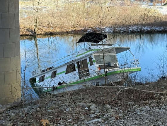
If you have driven past Harrods Creek recently, you may have noticed the large sinking houseboat just under the I-265 overpass. LMPD River Patrol and Suburban Towing are currently working to remove the vessel from the water. I want to thank LMPD River Patrol and Suburban Towing for their hard work and persistence. I especially want to thank Deputy Mayor Dana Mayton for helping us coordinate recovery efforts across several agencies.
From an ownership and government responsibility standpoint, this has been one of the more complicated and unique situations that I have been involved with during my time as Councilman.
I also want to thank the numerous residents who reached out to my office over the past two weeks. Each call and email helped us better understand the circumstances and ultimately contributed to helping us find a solution.
Please know that this situation is still ongoing, we will continue to monitor developments closely.
It is an honor to serve,
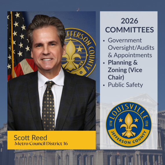
-Scott Reed
District 16
Councilman
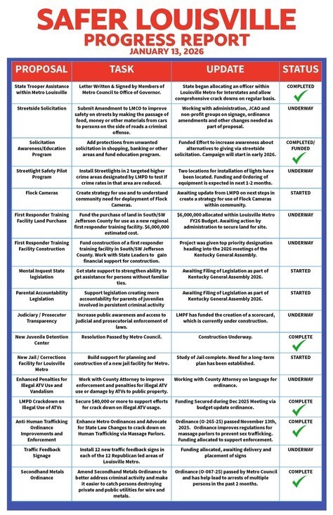
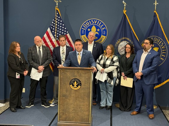 Watch the entire Safer Louisville Press Conference: Here
January 13, 2026
LOUISVILLE, Ky: Members of the Metro Council’s Minority Caucus held a press conference today to outline their progress on policy goals set within their “Safer Louisville” plan. During the event, members, led by Caucus Chair Anthony Piagentini (District 19) gave an update on each of the eighteen proposals set out during their September 2025 press event.
“Our ability to achieve our goals for creating first class job opportunities, improving housing and quality of life for our residents is dependent on our ability to provide a safe community. We appreciate the hard work of our first responders and have worked closely with them in crafting these policies. It is our hope that each of these will help to restore safety no matter where you reside.” – Minority Caucus Chair Anthony Piagentini, District 19
In addition to explaining where each policy proposal stood, members of the caucus announced the addition of two new policy proposals to the plan and unveiled a graphic that helps to track progress on each of the initiatives.
“These proposals aren’t about making people feel better – they are real changes and initiatives that are based on research and work with persons in law enforcement. When we unveiled these proposals four months ago, we pledged to give regular updates, so that everyone can know that there is substance to each. Today, we are following up on that promise and we are happy to show that we have already accomplished many of our goals with nearly every policy proposal moving towards implementation.” – Minority Caucus Vice Chair Khalil Batshon, District 25
A copy of the updated “Safer Louisville” policy paper as well as the scorecard for action for each of the proposals can be found by visiting the homepage for each of the twelve Republican members of the Metro Council. Members also intend to include the score card and policy updates which can be found below through their electronic newsletters and social media over the course of the next week.
A copy of the updated “Safer Louisville” proposals Report Card can be viewed using this link. For more information on this event, please contact Minority Caucus Director Stephen Haag at (502) 574-1204 or via email at steve.haag@louisvilleky.gov.
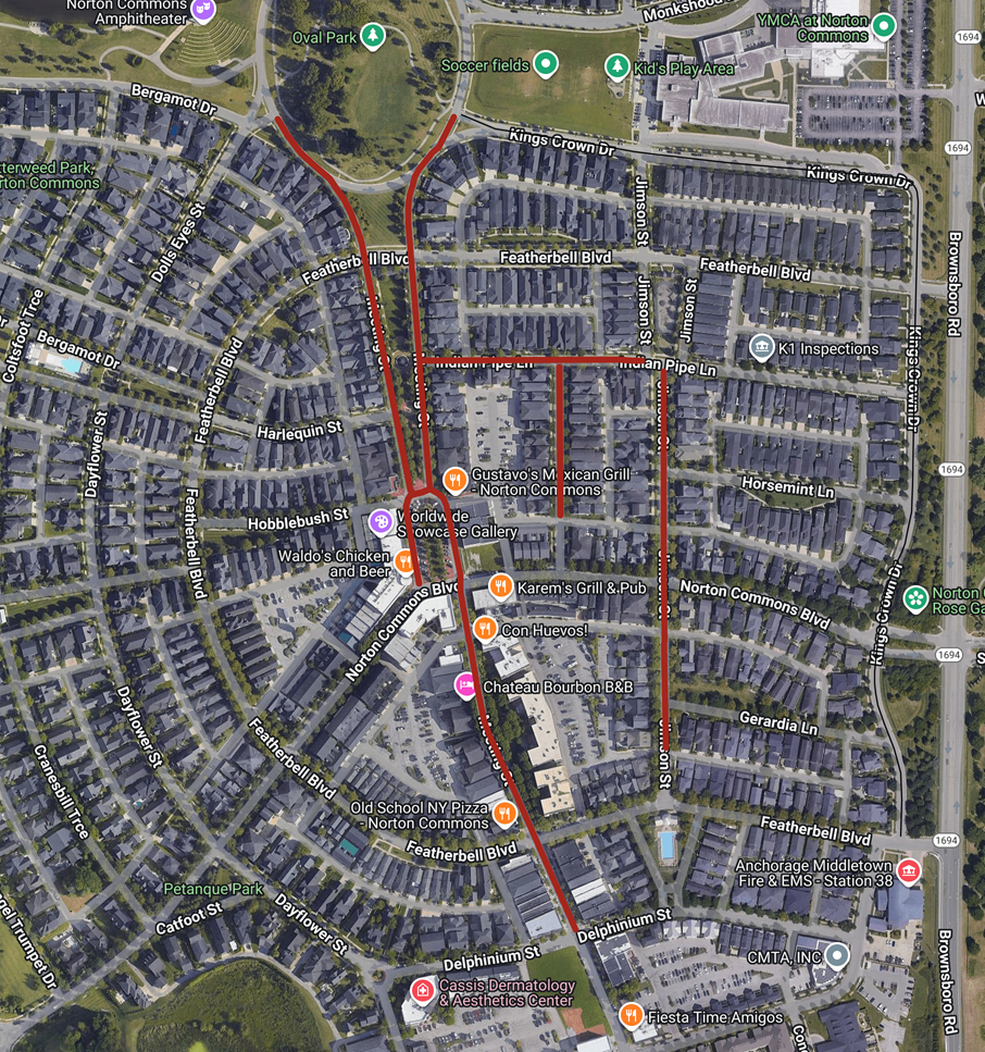
Greetings,
Due to Wednesday's rain, Precision Contracting will be extending Phase One of our joint beveling project into next week. Phase One includes Featherbell Blvd, Dayflower St, Harlequin St, Norton Commons Blvd, and Delphinium St.
Once Phase One is completed Precision will begin Phase Two, which will include Meeting Street and Indian Pipe. The scope of Phase Two is indicated on the map below, with areas of construction marked in red.
 External Agency Fund: Office of Social Services
External Agency Fund Applications Open
Louisville Metro Government is accepting applications, from local non-profit organizations seeking funding for programs or activities that support the mayor’s strategic goals. These grants, funded through the city’s General Fund, are awarded to non-governmental or “external” agencies via the External Agency Funds (EAF) program for Fiscal Year 2027 (July 1, 2026 – June 30, 2027).
The Office of Social Services has established FY27 EAF priorities that reflect Mayor Greenberg’s commitment to safe, healthy streets and equitable access to essential services for underserved populations. Selected partners will provide housing and supportive services to individuals experiencing homelessness who meet at least one of the U.S. Department of Housing and Urban Development (HUD) definitions of homelessness. Priority populations include:
- Seniors (age 55+) • Individuals with physical or mental disabilities • Persons reentering society after incarceration (including those convicted of serious crimes). Preference will be given to agencies serving individuals coming out of Louisville Metro Corrections. • Young adults (age 18–25) • Families with children
Supportive services may include case management, transitional housing, workforce training leading to employment opportunities, and financial education for the homeless.
Key Dates & Information
Application Guidelines Available: Click here for Guidelines. • Application Window Opens: Click here for Application Form. • OSS EAF Application Orientation: Tuesday, January 20, 2026, at 2:00 PM Join via this Webex meeting. • OSS EAF Office Hours: Tuesday, February 17, 2026, from 10:30 AM – 11:30 PM Join via this Webex meeting. • Additional Trainings: Louisville Metro Government will also host sessions on grant writing and Euna technical assistance. Please refer to the Guidebook for details. • Application Deadline: Tuesday, February 24, 2026, at 5:00 PM
Application Process
- Applications must be submitted through Euna. • Applicants may save and return to incomplete applications before final submission. • For technical support with Euna, contact: support.ecivis@eunasolutions.com • For general, non-urgent inquiries, email Karen.Moya@louisvilleky.gov • Current grantees should reach out to their assigned Grants Contract Coordinator.
 LOUISVILLE, Ky. (January 14, 2026) — Louisville Mayor Craig Greenberg and the Louisville Zoo invite the community to honor some of the Zoo’s most beloved residents at the Zoo’s first ever Birthday Bash on Saturday, January 24. This new event launches a monthly series of animal birthday celebrations that will continue throughout the year.
“Louisville is fortunate to have an amazing zoo with a wide variety of animals that call it home,” said Mayor Greenberg. “This new, fun-filled tradition is a great opportunity to celebrate our animal residents, adding to an already packed calendar of celebrations at the Louisville Zoo.”
Watch as these birthday stars enjoy species-specific custom enrichment treats designed just for them. Plus, guests can enjoy special keeper talks that reveal fascinating animal stories and care insights.
Birthday Bash Schedule (subject to change):
10:15 a.m. Siamang Darwin (23) Islands
10:30 a.m. Leopard Tortoises Esmerelda and Lavern (both 7) Giraffe bldg./Hyrax habitat
11 a.m. Western Lowland Gorilla Jelani (29) Gorilla Forest
11:15 a.m. Polar Bear Qannik (15, pronounced “KUN-ick”) Glacier Run
11:30 a.m. Hartmann’s Mountain Zebra Gibbs (19) Africa/Zebra
12:15 p.m. African Penguins Clyde (7) Islands
2 p.m. Linnaeus's two-toed sloth Fern (9) – keeper talk Sloth
2:15 p.m. Grey Seals Boone (22) and Rona (12) Glacier Run
The January Birthday Bash is free with Zoo admission. Plan your visit and see the full schedule at https://louisvillezoo.org/birthdaybash.
Drive-thru Microchip Clinic - January 18th, 9 - 11:30AM. First 50 receive free microchip, after that they are $10 per chip. Metro Animal Services, 3528 Newburg Road. Must be there by 11:30AM.
LOUISVILLE, Ky. (Jan. 16, 2026) – The Kentucky Transportation Cabinet (KYTC) advises motorists of overnight lane and ramp closures on Interstate 264 East (Watterson Expressway) beginning Monday, Jan. 19, as part of the $130 million widening and improvement project of I-264 and U.S. 42 (Brownsboro Road).
Scheduled lane and ramp closures:
- Beginning Monday, Jan. 19, at 8 p.m., through Tuesday, Jan. 20, at 6 a.m., the left lane of I-264 East will be closed between mile markers 23 and 22 (from the I-264/I-71 split to U.S. 42/Brownsboro Road). The lane closure is necessary for contract crews to deliver materials.
- Beginning Wednesday, Jan. 21, at 8 p.m., through Thursday, Jan. 22, at 6 a.m., the off-ramp from I-264 East to KY 22 at Exit 22 will be closed. The ramp closure is necessary for contract crews to install a waterline.
Motorists should heed signage, use caution when traveling through the work zone, and plan ahead for travel delays.
The highway improvement project is expected to be completed by the Fall of 2027. More details, including project timelines and traffic impacts, will be shared online as work progresses. Motorists are encouraged to sign up for email or text alerts regarding weekly traffic impacts pertaining to the project.
For the latest traffic and travel updates across the Commonwealth of Kentucky, visit goky.ky.gov. Information specific to District 5 counties is also available on Facebook and X.
LOUISVILLE, Ky. (Jan. 16, 2026) – As part of the $118 million widening and improvement project of Interstate 64 in Shelby County, the Kentucky Transportation Cabinet (KYTC) advises motorists of overnight closures of I-64 beginning Monday, Jan. 19.
I-64 West will be closed from 7 p.m. Monday, Jan. 19, through 7 a.m. Tuesday, Jan. 20, between mile points 35.3 and 34.9. Motorists should follow the posted detour of taking the off-ramp to KY 53 at Exit 35 to reconnect with I-64 West.
I-64 East will be closed from 7 p.m. Tuesday, Jan. 20, through 7 a.m. Wednesday, Jan. 21, between mile points 34.9 and 35.3. Motorists should follow the posted detour of taking the off-ramp to KY 53 at Exit 35 to reconnect with I-64 East. The overnight closures of the interstate are necessary for contract crews to demolish the KY 53 bridge over I-64 as part of the bridge replacement work. Motorists should expect travel delays and consider alternate routes.
All work being performed is part of the $118 million I-64 widening and improvement project in Shelby County, which began in February 2025. The project will increase capacity, upgrade a key interchange, and modernize bridges, ensuring a more efficient and reliable transportation network for motorists.
The three-year project includes widening and pavement upgrades of an 11-mile section of I-64, reconstruction of the KY 53 interchange, rebuilding of three bridges over I-64, and widening of four existing I-64 bridges. These improvements will enhance daily travel while also supporting future growth in the region.
The interstate project is expected to be completed by the Fall of 2027. More details, including project timelines and traffic impacts, will be shared online as work progresses. Motorists are encouraged to sign up for email alerts regarding weekly traffic impacts pertaining to the project.
The date and duration of this work may be adjusted if inclement weather or other unforeseen delays occur. Visit goky.ky.gov for the latest in traffic and travel information in the Commonwealth of Kentucky. You can also get traffic information for the District 5 counties on Facebook and X (formerly known as Twitter).
###
| Jefferson County |
|
| I-65 Central Corridor |
Information related to the I-65 Central Corridor project can be found online at i65centralcorridor.com.
|
U.S. 31E (Main Street)
*Main Remade* |
*Construction phasing details, including traffic impacts, are available online at: www.MainRemade.com
Latest press release:
https://lnks.gd/2/33z8p--
|
| I-64 East and West |
Traffic Impacts: Traffic is in its final configuration. Lane closures are possible as final items as part of the project are underway.
Date/Time: Daily/nightly.
Project Limits: I-64 East and West at mile point 11.799, near Exit 10 (Cannons Lane) on I-64 West, and near Exit 12 to I-264 (Watterson Expressway) on I-64 East.
Type of Work: Bridge replacement project.
Other Details: *Project announcement press release
|
| I-65 South |
Traffic Impacts: Lane reduction and road closure.
Date/Time: Through Feb. 2026.
Project Limits: I-65 South bridge at Exit 136C to Jefferson Street in downtown Louisville.
Type of work: Bridge maintenance project.
Other Details: During construction, the bridge will be reduced to a single 10-foot lane. Wide loads will not be permitted to use the ramp, and signage will be posted in advance to alert drivers of the restriction. In addition, South Floyd Street will be closed between East Jefferson Street and East Liberty Street. Drivers should follow the signed detour: East Liberty Street to South Jackson Street, left onto East Jefferson Street, and back to Liberty Street. Motorists are encouraged to plan ahead, follow posted signage, and use caution when driving through the work zone. |
| I-65 South (John F. Kennedy Memorial Bridge) |
**Latest project update and details: https://lnks.gd/3/3RJ3qVj
-----------------------------------------------
* Temporary Kennedy Bridge Closure
- Beginning at 8 p.m. Friday, Jan. 16, and continuing through 10 a.m. Saturday, Jan. 17, all lanes of I-65 South will be closed just past Exit 1 to U.S. 31 South/Stansifer Avenue/10th Street in Jeffersonville, Indiana. Motorists should plan to detour by taking I-265 West to I-64 East to reconnect with I-65 South.
-----------------------------------------------
Traffic Impacts: Closure of the right three lanes.
I-65 South (John F. Kennedy Memorial Bridge).
Type of Work: Expansion joint replacement project.
Other Details: The I-65 South to I-64 West ramp closure, which began Nov. 18, 2025, as part of the ongoing bridge expansion joint replacement project, will remain in place through January to support work on the southernmost expansion joint on the right side of the bridge. In addition to the ramp closure, the right three lanes and right shoulder of the Kennedy Bridge remain closed.
|
| I-65 North and I-264 East |
Traffic Impacts: Lane and ramp closures.
Date/Time: Friday, Jan. 16, at 7 p.m., through Sunday, Jan. 18, at 7 a.m.
Project Limits:
- The ramp from I-65 North to I-264 East will be closed.
- The ramp from KY 61 (Preston Highway) to I-264 East will be closed.
- The far right lane of I-65 North approaching the ramp to I-264 East, near the bridge over Standiford Lane (at mile point 130.04), will be closed.
Type of Work: Concrete slab repairs.
Other Details: These closures are necessary for contract crews to repair concrete slabs along the interstate and allow sufficient curing time. Motorists are urged to follow all lane and ramp closure restrictions, exercise caution in the work zone, and follow posted detour signage.
|
| I-264/U.S. 42 (Brownsboro Road) Improvement Project |
**Traffic impacts available here.**
|
| KY 841 North and South (Gene Snyder Freeway) |
Traffic Impacts: Single lane closures are possible.
Date/Time: Daily from 9 a.m. to 3 p.m., and nightly from 7 p.m. to 5 a.m.
Project Limits: KY 841 North and South (Gene Snyder Freeway), between mile point 35.0 and mile point 37.7, near and through the East End Tunnel.
Type of Work: Routine maintenance of the roadway and East End Tunnel.
Other Details: Motorists should heed signage, use caution, and adjust commutes to accommodate the lane closures. |
| KY 864 (Logan Street/Shelby Street) |
Traffic Impacts: Sidewalk and lane closures are possible.
Date/Time: Daily and nightly.
Project Limits: Between Goss Avenue and East Gray Street.
Type of Work: One-way to two-way conversion of the roadway.
Other Details: Major work has resumed, with full completion expected by Spring 2026.
*Project Webpage
|
| KY 1819 (Billtown Road) |
Traffic Impacts: Lane closures and delays are possible.
Date/Time: Daily – 9 a.m. to 4 p.m.
Project Limits: Three sections of KY 1819 (Billtown Road):
- Easum Road through Mary Dell Lane
- Michael Edward Drive through Fairground Road
- Shady Acres Lane through Colonnades Place
Type of Work: Reconstruction of KY 1819 (Billtown Road) from North of Colonnades Place to south of Easum Road with new traffic signals, signal optimization, turn lanes, storage lanes, etc. (varying by intersection based on existing conditions and future traffic projections).
Other Details: The reconstruction project is expected to be completed by the Spring of 2026.
*Project webpage
|
| KY 1932 (Chenoweth Lane) |
Traffic Impacts: Lane closures and delays are possible.
Date/Time: Daily and nightly.
Project Limits: KY 1932 (Chenoweth Lane) between U.S. 60 (Shelbyville Road) and U.S. 42 (Brownsboro Road).
Type of Work: Construction activities include roadway modifications, sidewalk and pedestrian crossing improvements, and drainage enhancements designed to reduce flooding and improve overall travel conditions in the area.
Other Details: This project is expected to be completed the Fall of 2026. |
I-264
*Various Exit Ramps |
Traffic Impacts: Ramp narrowing with intermittent lane and shoulder closures.
Project Limits: Various interchange Exit ramps on I-64 and I-264.
Type of Work: Installation and upgrade of wrong-way pavement markings and signs.
Other Details: The Highway Safety Improvement Project will install and enhance wrong-way signs and pavement markings on interstate Exit ramps to discourage wrong-way driving. Motorists should reduce speeds and obey traffic control while workers are present. This project is expected to be completed by the Fall of 2025. |
| |
|
| Bullitt County |
|
| KY 1526 (Bells Mill Road) |
Traffic Impacts: Road closure.
Date/Time: Beginning Monday, Nov. 17, through May 14, 2026.
Project Limits: KY 1526 (Bells Mill Road) will be closed at mile point 14.35 at the bridge over Floyds Fork.
Type of Work: Superstructure replacement.
Detour:
- For westbound traffic on KY 1526 (Bells Mill Road): Turn left onto KY 61 (Preston Highway) south toward Shepherdsville. At the signalized intersection, turn left onto KY 44 (East 4th Street) to reach KY 1526 (Bells Mill Road).
- For eastbound traffic on KY 1526 (Bells Mill Road): Turn right onto KY 44 (East 4th Street) through Shepherdsville. At the signalized intersection of KY 61 (Preston Highway), turn right to then reach KY 1526 (Bells Mill Road).
|
| |
|
| Franklin County |
|
| KY 12 (Flat Creek Road) |
Traffic Impacts: N/A.
Date/Time: Beginning Aug. 11, through the Fall of 2026.
Project Limits: KY 12 bridge over Flat Creek at mile point 12.46 (at the Franklin/Henry County line).
Type of Work: Bridge replacement project.
Other Details: Traffic will be maintained on the existing bridge until construction has been completed on the replacement bridge. |
| I-64 East and West |
Traffic Impacts: Lane closures and traffic shifts are possible.
Date/Time: Daily/nightly beginning Thursday, Sept. 4.
Project Limits: The I-64 East and West, between the Frankfort exits (mile markers 53 and 58).
Type of Work: The I-64 improvement project, between the Frankfort exits (mile markers 53 and 58), includes the milling and removal of the existing asphalt surface followed by resurfacing with new asphalt pavement. Other improvements to the 5-mile corridor include bridge repairs and bridge crash wall repairs.
Other Details:
- U.S. 60 (Versailles Road):
U.S. 60 (Versailles Road) will be reduced to one lane in each direction under the I-64 overpass bridge nightly from 9 p.m. to 6 a.m. beginning Monday, Sept. 15.
|
| U.S. 127/Vandalay Drive Intersection |
Traffic Impacts: Lane closures and traffic shifts are possible.
Date/Time: Daily/nightly.
Project Limits: U.S. 127/Vandalay Drive intersection.
Type of Work: The scope of the project includes constructing a new roundabout at the intersection of Vandalay Drive and Westridge Drive; extending Vandalay Drive to Limestone Drive to create a direct connection to KY 676 (East-West Connector); extending Vandalay Drive to U.S. 127 near the I-64/U.S. 127 interchange; and adding dual receiving lanes to improve left-turn movements from U.S. 127 onto Westridge Drive.
Other Details: The project is scheduled to be completed by the summer of 2026. |
| |
|
| Oldham County |
*Routine Maintenance* |
| |
|
| Spencer County |
*Routine maintenance* |
| |
|
| Shelby County |
|
| I-64 Widening and Improvement Project |
**Traffic impacts here.**
|
| |
|
| Henry County |
*Routine maintenance* |
| |
|
| Trimble County |
*Routine maintenance* |
| |
|
2025 Resurfacing Projects
Resurfacing projects will begin April 1, 2025, and
will be completed by the Fall of 2025.
Motorists should heed signage and use caution when traveling through the work zone.
| County / Road Name: |
Project Limits: |
| Jefferson County |
|
| U.S. 60 (Shelbyville Road) |
Begin at an asphalt joint west of U.S. 60A extending east to 53 ft west of Sherburn Ln Spur Conn/Ten Pin Ln, a distance of 01.85 miles |
| U.S. 60 (Shelbyville Road) |
Begin at Urton Lane/North English Station Road, extending east to an asphalt joint 0.038 miles west of Beckley Woods Drive/English State Way. |
U.S. 31 (West Main Street)
|
West Main St (US 31W southbound only) begins at US 150/West Main St, extending south to 145 ft north of US 31, a distance of 1.78 miles. |
| KY 907 (Valley Station Road/Third Street Road) |
Begin at U.S. 31E extending north to Arnoldtown Road, a distance of 3.99 miles |
| KY 1065 (Outer Loop) |
Begin at KY 907 extending east to a concrete joint at KY 1020, a distance of 02.48 miles |
| KY 61 (Preston Highway) |
Begin at the north end of the bridge over I-265 extending north to 0.026 miles south of Okolona Ter, a distance of 01.86 miles |
KY 1230 (Lower River Road)
|
From Tennis Blvd, west 0.093 miles, extending northerly to KY 1934, a distance of 2.62 miles. |
KY 2830 (Arthur Street)
*Completed* |
KY 2830 (Arthur Street) east of Brandies Avenue/KY 61 extending north to University Boulevard. |
U.S. 31E (Bardstown Road)
*Completed* |
U.S. 31E (Bardstown Road) at the Bullitt/Jefferson County line, extending south of Colonel Hancock Drive. |
KY 1631 (Crittenden Drive)
*Completed* |
KY 1631 (Crittenden Drive) at the beginning of state maintenance near the I-264 interchange, extending north to U.S. 60A (Eastern Parkway). |
KY 1531 (Johnson Road)
*Completed* |
KY 1531 (Johnson Road) from the railroad crossing extending north to Aiken Road. |
KY 61 (Arthur Street)
*Completed* |
KY 61 (Arthur Street) beginning east of Brandies Avenue extending north to I-65 ramp/East Gaulbert Avenue. |
KY 155 (Taylorsville Road)
*Completed* |
KY 155 (Taylorsville Road) beginning at KY 1747 (Hurstbourne Lane) extending north to KY 1932 (Breckenridge Lane). |
KY 329 (Covered Bridge Road)
*Completed* |
KY 329 (Covered Bridge Road) beginning at U.S. 42 extending east to the Jefferson/Oldham County line. |
| |
|
| Bullitt County |
|
KY 61 (Old Preston Highway)
|
Begin at KY 61 extending north to 0.165 miles north Hillsbrook Dr, a distance of 0.87 miles
|
KY 61 (North Preston Highway)
|
Begin 21 ft north of KY 2553 extending north to Bullitt/Jefferson County line, a distance of 01.58 miles
|
| KY 480 (Cedar Grove Road) |
Begin 0.113 miles east of Park Loop Rd/Valley Vw Dr extending east to 0.077 miles east of KY 1442, a distance of 0.42 miles |
KY 1442 (Ridge Road)
|
Ridge Rd/Clarks Ln from McCubbins Farm Ln, south 0.056 mile, extending easterly towards Paddock Rd, a distance of 4.90 miles. |
KY 1604 (Deatsville Road)
|
From KY 245, extending northerly towards Jackson Hollow Rd, a distance of 3.20 miles. |
KY 1531 (Dawson Hill Road)
*Completed* |
KY 1531 (Dawson Hill Road) from KY 1319 extending north to the Bullitt/Jefferson County line. |
KY 2672 (Knob Creek Road)
*Completed* |
KY 2672 (Knob Creek Road) from KY 1526 (Brooks Hill Road) extending north towards Lake Elmo Road. |
KY 2674 (Stringer Lane)
*Completed* |
KY 2674 (Stringer Lane) from U.S. 31E extending north to KY 44. |
| |
|
| Franklin County |
|
| U.S. 60 (Louisville Road) |
Begin at the east end of Benson Creek Bridge extending east to mile point .025 just east of Office Park Drive. |
| KY 12 (Dry Ridge Road/Flat Creek Road) |
KY 12 (Dry Ridge Road/Flat Creek Road) from the Shelby/Franklin County line extending east to Harvieland Road. |
| KY 1570 (St Johns Road) |
KY 1570 (St Johns Road) from the bridge at mile point 4.2, extending north to KY 12. |
| U.S. 127 (Wilkinson Boulevard) |
U.S. 127 (Wilkinson Boulevard) near Hall Street extending north to the south end of the U.S. 127/KY 2261 bridge. |
| |
|
| Oldham County |
|
| KY 53 (North First Avenue) |
Begin at KY 146 extending north to US 42 (MP 11.045), a distance of 03.99 miles |
KY 524 (Westport Road)
|
From US 42, extending northerly towards Smith Ln, a distance of 1 mile. |
KY 362 (Central Avenue)
*Completed* |
KY 362 (Central Avenue) from Rosswoods Drive extending south towards KY 146. |
KY 329 (Covered Bridge Road)
*Completed* |
KY 329 (Covered Bridge Road) from KY 329B extending east to mile point 8.754. |
| KY 393 (Crestwood to La Grange) |
Begin at KY 22 extending north to the south end of the North Fork Bridge, a distance of 1.99 miles |
KY 393 (Payton Lane)
|
From KY 1818, extending northerly to KY 22, a distance of 2.56 miles. |
KY 1694 (Gum Street)
*Completed* |
KY 1694 (Gum Street) from KY 329 extending north towards Mason Lane. |
KY 3223 (Old Sligo Road)
|
From KY 53, extending northerly to Ballard School Rd, a distance of 1.55 miles. |
U.S. 42
*Completed* |
U.S. 42 east of KY 1694 (Gum Street) extending east to the Oldham/Henry County line. |
| |
|
| Shelby County |
|
U.S.421 (Castle Highway)
|
Begin 21 feet north of KY 3322 extending north to KY 55, a distance of 2.82 miles. Castle Highway begins at Henry/Shelby County line extending north to the Shelby/Henry County line, a distance of 0.79 mile. |
KY 22 (Ballardsville Road)
|
Begin at Oldham/Henry County line extending east to KY 55, a distance of 7.02 miles |
KY 362 (Aiken Road)
*Completed* |
KY 362 (Aiken Road) from the Oldham/Shelby County line extending east near Webb Road. |
| U.S. 60 (Frankfort Road) |
U.S. 60 (Frankfort Road) beginning at KY 395 extending east to the Shelby/Franklin County line. |
KY 1408 (Floydsburg Road)
*Completed* |
KY 1408 (Loydsburg Road) from KY 362 extending west to the Shelby/Oldham County line. |
KY 322 (Lucas Road)
*Completed* |
KY 322 (Lucas Road) from KY 53 extending north to the Shelby/Henry County line. |
KY 53 (Mt. Eden Road)
*Completed* |
KY 53 (Mt. Eden Road) beginning at KY 714/KY 44 extending north to KY 1790 (Hooper Station Road). |
| |
|
| Spencer County |
|
KY 1392 (Grays Run Road)
*Completed* |
Begin at the east end of Simpsonville Creek Bridge extending east to KY 55, a distance of 2.64 miles |
KY 1633 (Elk Creek Road)
*Completed* |
KY 1633 (Elk Creek Road) from KY 1135 (Industrial Road) extending north to KY 55.
|
KY 1795 (Mill Road)
*Completed* |
KY 1795 (Mill Road) from Paradise Pointe Road extending east to KY 636. |
KY 55 (Shelbyville Road)
*Completed* |
KY 55 (Shelbyville Road) beginning at KY 155 extending north to the Spencer/Shelby County line. |
| |
|
| Henry County |
|
U.S.421 (Castle Highway)
|
Begin 21 feet north of KY 3322 extending north to KY 55, a distance of 2.82 miles. Castle Highway begins at Henry/Shelby County line extending north to the Shelby/Henry County line, a distance of 0.79 mile. |
U.S. 421 (Campbellsburg Road)
*Completed* |
U.S. 421 (Campbellsburg Road) at the I-71 overpass extending to the Henry/Trimble County line. |
KY 22 (Ballardsville Road)
|
Begin at Oldham/Henry County line extending east to KY 55, a distance of 7.02 miles
|
KY 1360 (Franklinton Road)
*Completed* |
KY 1360 (Franklinton Road) from KY 22 extending north to Bullitt Hill Road.
|
KY 241 (Pleasureville Road)
*Completed* |
KY 241 (Pleasureville Road) beginning at the Shelby/Henry County line extending north to U.S. 421. |
KY 1861 (Smithfield Road)
*Completed* |
KY 1861 (Smithfield Road) from KY 22 extending to KY 322. |
We now have a new way for you to map crime around you. Just click here and view our new interactive crime mapping tool for Division 5 & 8 or for each beat in Division 5 & 8. And save it in your favorites to view crime anytime it's updated daily. On the page is a Quickfind tool that allows you to put your address in and subscribe to crime trends, alerts and block watch reports for your police beat. Forward this email to your friends and family!
For further information on Councilman Scott Reed or District 16 please visit www.louisvilleky.gov/government/metro-council-district-16
You can also reach out directly by phone at 502.574.1116 or by email at scott.reed@louisvilleky.gov.
601 West Jefferson Street
Louisville, KY 40202
Having Trouble Viewing this eNewsletter? Click here to view it on the web.
|