 Two weeks ago, Councilman Reed had the pleasure of attending a ribbon-cutting ceremony for Dry Needling Relief, a new wellness practice now open in Norton Commons. Owned and operated by Dr. Brooks, this locally owned clinic specializes in dry needling therapy—a technique designed to relieve muscular pain and improve mobility.
Please join us in welcoming Dry Needling Relief to the neighborhood and congratulating Dr. Brooks on opening her own practice.
 Earlier today, I received notice from Public Works that River Road will be closed between Timber Ridge Drive and Mayfair Avenue starting Monday, August 18. The closure is expected to last for two weeks, with the goal of reopening in time for Labor Day weekend. Motorists are advised to follow detour and safety signage.
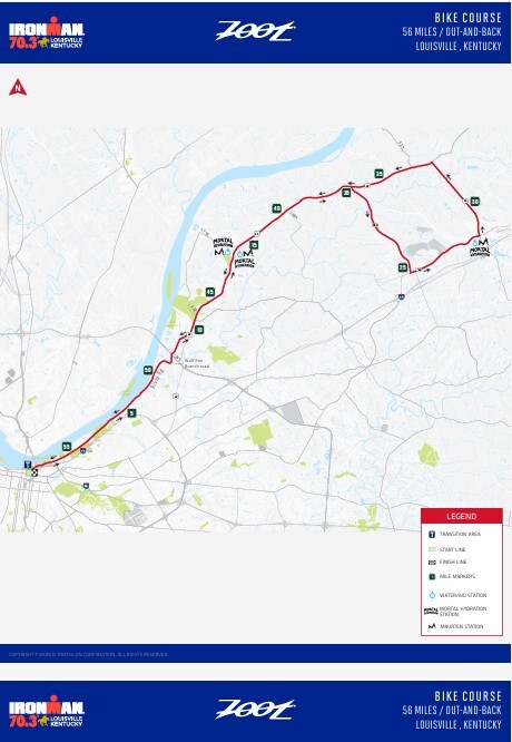
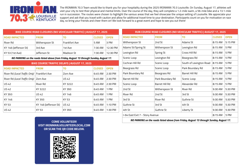
Sunday, August 17, 2025 - 2025 Ironman 70.3
5 am - 3 pm
- River Road from Witherspoon Street to Frankfort Avenue
7:30 am - 12:30 pm (La Grange in Oldham County)
- KY 146 (Jefferson Street) from 3rd Avenue to 1st Avenue
- KY 53 (1st Avenue) from Jefferson Street to Madison Street
8:15 am - 5 pm
- Witherspoon Street from 2nd Street to Adams Street
- Adams Street/Spring Street from Witherspoon Street to Lexington Road
- Lexington Road from Spring Street to Cross Hill Road
- Scenic Loop from Lexington Road to Beargrass Road
- Cochran Hill Road from Scenic Loop to South of Lexington Road
- Beargrass Road from Scenic Loop to Park Boundary Road
- Park Boundary Road from Beargrass Road to Barret Hill Road
- Barret Hill Road from Park Boundary Road to Scenic Loop
- Scenic Loop from Barret Hill Road to Alexander Road
- Scenic Loop from Alexander Road to Scenic Loop
- I-64 East Story Avenue Exit 7
9:30 am - 5:30 pm
- 2nd Street from Witherspoon Street to River Road
- River Road from 2nd Street to 3rd Street
- 3rd Street from River Road to Guthrie Street
- Guthrie Street from 3rd Street to 4th Street
- 4th Street from Guthrie Street to Liberty Street
Traffic Control Measures (traffic allowed when course is empty)
6:45 am - 2:30 pm
- River Road from Frankfort Avenue to Zorn Avenue (local traffic only)
- River Road from Zorn Avenue to US 42 (local traffic only)
- US 42 from River Road to KY 3222
6:45 am - 1:30 pm (Oldham County)
- US 42 from KY 3222 to KY 393
- KY 393 from US 42 to KY 146
- KY 146 from KY 393 to KY 53
- KY 53 from KY 146 (Jefferson Street) to US 42
- US 42 from KY 53 to KY 393
No Parking
Midnight, Thursday, August 14, 2025 - 7 pm, Sunday, August 17, 2025
- River Road from Witherspoon Street to Frankfort Avenue
- Witherspoon Street from 2nd Street to Adams Street
- Adams Street/Spring Street from Witherspoon Street to Lexington Road
- Lexington Road from Spring Street to Grinstead Drive
- Scenic Loop from Grinstead Drive to Beargrass Road
- Cochran Hill Road from Scenic Loop to South of Lexington Road
- Beargrass Road from Scenic Loop to Park Boundary Road
- Park Boundary Road from Beargrass Road to Barret Hill Road
- Barret Hill Road from Park Boundary Road to Scenic Loop
- Scenic Loop from Barret Hill Road to Alexander Road
- Scenic Loop from Alexander Road to Scenic Loop
- 2nd Street from Witherspoon Street to River Road
- River Road from 2nd Street to 3rd Street
- 3rd Street to River Road to Guthrie Street
- Guthrie Street from 3rd Street to 4th Street
- 4th Street from Guthrie Street to Liberty Street
Click Map to view larger image
Last Friday, the life of a mother and two of her children were put into jeopardy by the alleged acts of a convicted violent offender who somehow received shock probation after serving only five months of a fourteen-year sentence. This family will forever be impacted by the actions of this repeat, violent criminal but we must remember that this is only the latest tragic story of the prosecutorial and judicial system releasing criminals early who then continue to terrorize our community.
The events of this day have helped bring to light a problem that state legislators as well as members of this caucus have tried to address. While police are the front lines in addressing crime and acts of violence, the effort to create safer streets also requires a justice system that holds criminals accountable for their actions. While LMPD wears body cameras and has all of their actions scrutinized daily, we have not seen that level of scrutiny of local prosecutors and judges. For example, there have been over 300 cases of shock probation granted in the past year and a half and nobody knows how many of those cases, including this one, resulted in those people breaking probation or committing new crimes after serving a tiny fraction of their original sentence.
The decision to offer shock probation to this convicted violent offender was a terrible mistake. This wasn’t the first time this has occurred, but it can be the last. In the coming weeks, Republican members of the Metro Council’s Minority Caucus will work to create lasting policy initiatives that will help bring greater transparency to our court system along with proposals that will support our collective goal of creating a safer community.
September is Law Enforcement Appreciation Month. We plan to use that time to not only show our appreciation for our officers, but also to help spread the knowledge that making our community safer will take the work of all of us and not just the brave officers within law enforcement.
Louisville area’s required use of government mandated reformulated gas is coming closer to an end. This move follows continued pressure residents and elected officials within the City of Louisville as well as State Elected Leaders in the Kentucky General Assembly. In response, the Mayor, as well as Governor, have moved forward with a proposal to end the Louisville area’s requirement to use reformulated gas. The effectiveness and supposed benefits of RFG have been called into question for years. Reports suggest that not only was the gas more expensive for residents of the area, but it also didn’t burn as efficiently, which potentially led to other environmental harms.
In 2008 the Metro Council passed a resolution called for the elimination of EPA requirement to use RFG. Members then urged the Mayor and Metro Air Pollution Control District to submit a proposal that would allow for this to occur. More recently, changes in administrations as well as an increased push by legislators such as State Representatives Emily Callaway and Jarad Bauman, and State Senators Mike Nemes, Julie Adams, and Aaron Reed helped secure state support for this change.
This week, Mayor Greenberg signaled that the work at the local and state level were complete and that the final decision to remove the requirement for the Louisville area to use a specific type of boutique RFG was submitted to the EPA for their final approval.
If this proposal is accepted, every Louisville driver could see savings at the pump in the summer months. It is estimated that the use of specific types of gas, such as the ones prescribed for Louisville increase the per gallon cost of unleaded gasoline by ten to twenty-five cents per gallon during the summer months.
We thank those leaders who joined together to help to bring about these changes and fully support this proposed change.

| Jefferson County |
|
U.S. 31E (Main Street)
*Main Remade – East Phase |
Traffic Impacts: Sidewalk and lane closures are possible.
Date/Time: Daily.
Project Limits: U.S. 31E (Main Street) between Wenzel Street and 2nd Street.
Type of Work: One-way to two-way conversion. In addition to the new two-way configuration, other improvements coming to the corridor include upgrades to crosswalks and intersections, a protected bike lane, dedicated left-turn lanes, and new traffic signals.
***Construction phasing details are available online at: www.MainRemade.com
|
| I-64 East and West |
Traffic Impacts: Lane closures and traffic shifts are possible.
Date/Time: Daily and nightly.
Project Limits: I-64 East and West at mile point 11.799, near Exit 10 (Cannons Lane) on I-64 West, and near Exit 12 to I-264 (Watterson Expressway) on I-64 East.
Type of Work: Bridge replacement project.
Other Details: **Eastbound and westbound traffic is shifted to the outer shoulders. Construction is currently taking place in the median, and two 11-foot lanes will remain open in each direction for the duration of the project.
*Press release
|
| I-65 South (John F. Kennedy Memorial Bridge) |
Traffic Impacts: Closure of the right three lanes.
Project Limits: I-65 South (John F. Kennedy Memorial Bridge).
Type of Work: Expansion joint replacement project.
Other Details: The right three lanes and right shoulder of the bridge carrying I-65 South over the Ohio River will remain closed through the end of 2025 for ongoing construction activities. While lane closures span the entire length of the bridge, access to I-64 and I-71 will be maintained throughout the duration of the work.
*July 28, 2025 press release
*June 3, 2025 press release
*March 31, 2025 press release
*February 27, 2025 press release
|
| I-264/U.S. 42 (Brownsboro Road) Improvement Project |
*Traffic impacts available here.
|
| KY 841 (Gene Snyder Freeway) |
Traffic Impacts: Single lane closures are possible.
Date/Time: Beginning Sunday, Aug. 17, through Saturday, Aug. 23.
Daily – 9 a.m. to 3 p.m. | Nightly – 7 p.m. to 5 a.m.
Project Limits: KY 841 North and South (Gene Snyder Freeway), between mile points 35.0 and 37.7, near and through the East End Tunnel.
Type of Work: Routine maintenance of the roadway and East End Tunnel.
Other Details: Motorists should heed signage, use caution, and adjust commutes to accommodate lane closures. |
| KY 864 (Logan Street/Shelby Street) |
Traffic Impacts: Sidewalk and lane closures are possible.
Date/Time: Daily and nightly.
Project Limits: Between Goss Avenue and East Gray Street.
Type of Work: One-way to two-way conversion of the roadway.
Other Details: Major work has resumed, with full completion expected by the Spring of 2026.
*The traffic signals at Logan/Mary, Logan/Breckinridge, Logan/Oak, Shelby/Breckinridge are currently set to flash for STOP conditions. On Sept. 1, 2025, the signals are scheduled to be activated. Motorists should use caution and adhere to the temporary traffic pattern. |
| KY 1819 (Billtown Road) |
Traffic Impacts: Lane closures and delays are possible.
Date/Time: Daily – 9 a.m. to 4 p.m.
Project Limits: Three sections of KY 1819 (Billtown Road):
- Easum Road through Mary Dell Lane
- Michael Edward Drive through Fairground Road
- Shady Acres Lane through Colonnades Place
Type of Work: Reconstruction of KY 1819 (Billtown Road) from north of Colonnades Place to south of Easum Road with new traffic signals, signal optimization, turn lanes, storage lanes, etc. (varying by intersection based on existing conditions and future traffic projections).
Other Details: The reconstruction project is expected to be completed by the Summer of 2025.
*Project webpage
|
I-64 and I-264
*Various Exit Ramps |
Traffic Impacts: Ramp narrowing with intermittent lane and shoulder closures.
Project Limits: Various interchange Exit ramps on I-64 and I-264.
Type of Work: Installation and upgrade of wrong-way pavement markings and signs.
Other Details: The Highway Safety Improvement Project will install and enhance wrong-way signs and pavement markings on interstate Exit ramps to discourage wrong-way driving. Motorists should reduce speeds and obey traffic control while workers are present. This project is expected to be completed by the Fall of 2025. |
| *Various Locations |
Traffic Impacts: Lane closures and delays are possible as part of a mobile operation.
Date/Time: Nightly – 8 p.m. to 5 a.m.
Type of Work: Pavement striping.
Other Details: Motorists should provide plenty of space to crews displaying "WET PAINT" signage and be observant of slowed vehicles while traveling through the work zone. |
| |
|
| Bullitt County |
|
| I-65/KY 480 (Cedar Grove Road) |
Traffic Impacts: Changing traffic patterns, lane shifts, and lane closures are possible as final construction activities are underway.
Date/Time: Daily and nightly.
Project Limits: KY 480 (Cedar Grove Road) between I-65 (mile points 0.6 and 1.4).
Type of Work: Reconstruction of the KY 480/I-65 interchange, including the construction of a double crossover diamond.
Other Details: The interchange reconstruction project is now in its final configuration. The project is expected to be completed by the Fall of 2025.
|
| KY 1442 (Ridge Road) |
Traffic Impacts: Road closure.
Date/Time: Beginning Monday, Aug. 18, at 8 a.m. through 3 p.m.
Project Limits: KY 1442 (Ridge Road) between mile points 1.9 and 2.0 (near Clearview Farm Road), and between mile points 3.7 and 3.8 (near Light Lane).
Type of Work: Cross drain replacement.
Other Details: Following the replacement of the cross drain, crews will place a layer of dense-grade rock over it until asphalt can be laid. Drivers should exercise caution when driving over the newly replaced cross drain. |
| KY 1604 (Deatsville Road) |
Traffic Impacts: Road closure.
Date/Time: Beginning Tuesday, Aug. 19, at 8 a.m. through 3 p.m.
Project Limits: KY 1604 (Deatsville Road) between mile points 1.0 and 1.3.
Type of Work: Cross drain replacement.
Other Details: Following the replacement of the cross drain, crews will place a layer of dense-grade rock over it until asphalt can be laid. Drivers should exercise caution when driving over the newly replaced cross drain. |
| *Various Locations |
Traffic Impacts: Lane closures and delays are possible as part of a mobile operation.
Date/Time: Daily – 7 a.m. to 11 p.m.
Type of Work: Pavement striping.
Other Details: Motorists should provide plenty of space to crews displaying "WET PAINT" signage and be observant of slowed vehicles while traveling through the work zone. |
| |
|
| Franklin County |
|
| KY 12 |
Traffic Impacts: N/A.
Date/Time: Beginning Aug. 11, through Dec. 1.
Project Limits: KY 12 bridge over Flat Creek at mile point 12.46 (at the Franklin/Henry County line).
Type of Work: Bridge replacement project.
Other Details: Traffic will be maintained on the existing bridge until construction has been completed on the replacement bridge. |
| U.S. 60 (Louisville Road) |
Traffic Impacts: Lane closures are possible.
Date/Time: Daily.
Project Limits: U.S. 60 (Louisville Road) from mile point .023 to mile point 3.89.
Type of Work: Base failure repairs ahead of an upcoming asphalt resurfacing project.
Other Details: Motorists should heed signage, use caution, and expect delays. |
| U.S. 127/Vandalay Drive Intersection |
Traffic Impacts: Lane closures and traffic shifts are possible.
Date/Time: Daily/nightly.
Project Limits: U.S. 127/Vandalay Drive intersection.
Type of Work: The scope of the project includes constructing a new roundabout at the intersection of Vandalay Drive and Westridge Drive; extending Vandalay Drive to Limestone Drive to create a direct connection to KY 676 (East-West Connector); extending Vandalay Drive to U.S. 127 near the I-64/U.S. 127 interchange; and adding dual receiving lanes to improve left-turn movements from U.S. 127 onto Westridge Drive.
Other Details: The project is scheduled to be completed by the summer of 2026. |
| KY 1665 (Bridgeport-Benson Road) |
Traffic Impacts: Closure.
Date/Time: Beginning Monday, July 7, through Sunday, September 7.
Project Limits: KY 1665 (Bridgeport-Benson Road) bridge over South Benson Creek at mile point 3.93.
Type of Work: Bridge replacement. |
| |
|
| Oldham County |
|
| KY 53 (North First Avenue) |
Traffic Impacts: Lane closures and restricted street parking.
Date/Time: Nightly – 6 p.m. to 6 a.m. beginning Sunday, Aug. 17, through Sunday, Aug. 24.
Project Limits: KY 53 (North First Avenue) beginning at KY 146 and extending north to U.S. 42 at mile point 11.045.
Type of Work: Asphalt resurfacing.
|
| *Various Locations |
Traffic Impacts: Lane closures and delays are possible as part of a mobile operation.
Date/Time: Daily – 7 a.m. to 11 p.m.
Project Limits:
Type of Work: Pavement striping.
Other Details: Motorists should provide plenty of space to crews displaying "WET PAINT" signage and be observant of slowed vehicles while traveling through the work zone. |
| |
|
| Spencer County |
*Routine maintenance* |
| |
|
| Shelby County |
|
| I-64 Widening and Improvement Project |
*Traffic impacts here.
|
| U.S. 60 (Frankfort Road) |
Traffic Impacts: Lane closures are possible.
Date/Time: Daily.
Project Limits: U.S. 60 (Frankfort Road) from mile point 19.338 at KY 395 to mile point 23.0 at the Franklin/Shelby County line.
Type of Work: Base failure repairs ahead of an upcoming asphalt resurfacing project.
Other Details: Motorists should heed signage, use caution, and expect delays. |
| *Various Locations |
Traffic Impacts: Lane closures and delays are possible as part of a mobile operation.
Date/Time: Daily – 7 a.m. to 11 p.m.
Type of Work: Pavement striping.
Other Details: Motorists should provide plenty of space to crews displaying "WET PAINT" signage and be observant of slowed vehicles while traveling through the work zone. |
| |
|
| Henry County |
*Routine maintenance* |
| |
|
| Trimble County |
*Routine maintenance* |
| 2025 Resurfacing Projects |
*Resurfacing projects will begin on or after April 1, 2025, and will be completed by the Fall of 2025. Motorists should heed signage and use caution when traveling through the work zone.* |
| |
|
| Jefferson County |
|
| U.S. 60 (Shelbyville Road) |
Project Limits:
Begin at an asphalt joint west of U.S. 60A extending east to 53 ft west of Sherburn Ln Spur Conn/Ten Pin Ln, a distance of 01.85 miles |
| U.S. 60 (Shelbyville Road) |
Project Limits:
Begin at Urton Lane/North English Station Road extending east to an asphalt joint 0.038 miles west of Beckley Woods Drive/English State Way. |
| KY 907 (Valley Station Road/Third Street Road) |
Project Limits:
Begin at U.S. 31E extending north to Arnoldtown Road, a distance of 3.99 miles |
| KY 1065 (Outer Loop) |
Project Limits:
Begin at KY 907 extending east to a concrete joint at KY 1020, a distance of 02.48 miles |
| KY 61 (Preston Highway) |
Project Limits:
Begin at the north end of the bridge over I-265 extending north to 0.026 miles south of Okolona Ter, a distance of 01.86 miles |
KY 2830 (Arthur Street)
*Completed* |
Project Limits:
KY 2830 (Arthur Street) east of Brandies Avenue/KY 61 extending north to University Boulevard. |
U.S. 31E (Bardstown Road)
*Completed* |
Project Limits:
U.S. 31E (Bardstown Road) at the Bullitt/Jefferson County line, extending south of Colonel Hancock Drive. |
KY 1631 (Crittenden Drive)
*Completed* |
Project Limits:
KY 1631 (Crittenden Drive) at the beginning of state maintenance near the I-264 interchange, extending north to U.S. 60A (Eastern Parkway). |
KY 1531 (Johnson Road)
*Completed* |
Project Limits:
KY 1531 (Johnson Road) from the railroad crossing extending north to Aiken Road. |
KY 61 (Arthur Street)
*Completed* |
Project Limits:
KY 61 (Arthur Street) beginning east of Brandies Avenue extending north to I-65 ramp/East Gaulbert Avenue. |
KY 155 (Taylorsville Road)
*Completed* |
Project Limits:
KY 155 (Taylorsville Road) beginning at KY 1747 (Hurstbourne Lane) extending north to KY 1932 (Breckenridge Lane). |
KY 329 (Covered Bridge Road)
*Completed* |
Project Limits:
KY 329 (Covered Bridge Road) beginning at U.S. 42 extending east to the Jefferson/Oldham County line. |
| |
|
| Bullitt County |
|
KY 61 (Old Preston Highway)
|
Project Limits:
Begin at KY 61 extending north to 0.165 miles north Hillsbrook Dr, a distance of 0.87 miles
|
KY 61 (North Preston Highway)
|
Project Limits:
Begin 21 ft north of KY 2553 extending north to Bullitt/Jefferson County line, a distance of 01.58 miles
|
| KY 480 (Cedar Grove Road) |
Project Limits:
Begin 0.113 miles east of Park Loop Rd/Valley Vw Dr extending east to 0.077 miles east of KY 1442, a distance of 0.42 miles |
KY 1531 (Dawson Hill Road)
*Completed* |
Project Limits:
KY 1531 (Dawson Hill Road) from KY 1319 extending north to the Bullitt/Jefferson County line. |
KY 2672 (Knob Creek Road)
*Completed* |
Project Limits:
KY 2672 (Knob Creek Road) from KY 1526 (Brooks Hill Road) extending north towards Lake Elmo Road. |
KY 2674 (Stringer Lane)
*Completed* |
Project Limits:
KY 2674 (Stringer Lane) from U.S. 31E extending north to KY 44. |
| |
|
| Franklin County |
|
| U.S. 60 (Louisville Road) |
Project Limits:
Begin at the east end of Benson Creek Bridge extending east to mile point .025 just east of Office Park Drive. |
| KY 12 (Dry Ridge Road/Flat Creek Road) |
Project Limits:
KY 12 (Dry Ridge Road/Flat Creek Road) from the Shelby/Franklin County line extending east to Harvieland Road. |
| KY 1570 (St Johns Road) |
Project Limits:
KY 1570 (St Johns Road) from the bridge at mile point 4.2, extending north to KY 12. |
| U.S. 127 (Wilkinson Boulevard) |
Project Limits:
U.S. 127 (Wilkinson Boulevard) near Hall Street extending north to the south end of the U.S. 127/KY 2261 bridge. |
| |
|
| Oldham County |
|
| KY 53 (North First Avenue) |
Project Limits:
Begin at KY 146 extending north to US 42 (MP 11.045), a distance of 03.99 miles |
KY 362 (Central Avenue)
*Completed* |
Project Limits:
KY 362 (Central Avenue) from Rosswoods Drive extending south towards KY 146. |
KY 329 (Covered Bridge Road)
*Completed* |
Project Limits:
KY 329 (Covered Bridge Road) from KY 329B extending east to mile point 8.754. |
| KY 393 (Crestwood to La Grange) |
Project Limits:
Begin at KY 22 extending north to the south end of the North Fork Bridge, a distance of 1.99 miles |
KY 1694 (Gum Street)
*Completed* |
Project Limits:
KY 1694 (Gum Street) from KY 329 extending north towards Mason Lane. |
U.S. 42
*Completed* |
Project Limits:
U.S. 42 east of KY 1694 (Gum Street) extending east to the Oldham/Henry County line. |
| |
|
| Shelby County |
|
KY 362 (Aiken Road)
*Completed* |
Project Limits:
KY 362 (Aiken Road) from the Oldham/Shelby County line extending east near Webb Road. |
| U.S. 60 (Frankfort Road) |
Project Limits:
U.S. 60 (Frankfort Road) beginning at KY 395 extending east to the Shelby/Franklin County line. |
KY 1408 (Loydsburg Road)
*Completed* |
Project Limits:
KY 1408 (Loydsburg Road) from KY 362 extending west to the Shelby/Oldham County line. |
KY 322 (Lucas Road)
*Completed* |
Project Limits:
KY 322 (Lucas Road) from KY 53 extending north to the Shelby/Henry County line. |
KY 53 (Mt. Eden Road)
*Completed* |
Project Limits:
KY 53 (Mt. Eden Road) beginning at KY 714/KY 44 extending north to KY 1790 (Hooper Station Road). |
| |
|
| Spencer County |
|
KY 1392 (Grays Run Road)
*Completed* |
Project Limits:
Begin at the east end of Simpsonville Creek Bridge extending east to KY 55, a distance of 2.64 miles |
KY 1633 (Elk Creek Road)
*Completed* |
Project Limits:
KY 1633 (Elk Creek Road) from KY 1135 (Industrial Road) extending north to KY 55.
|
KY 1795 (Mill Road)
*Completed* |
Project Limits:
KY 1795 (Mill Road) from Paradise Pointe Road extending east to KY 636. |
KY 55 (Shelbyville Road)
*Completed* |
Project Limits:
KY 55 (Shelbyville Road) beginning at KY 155 extending north to the Spencer/Shelby County line. |
| |
|
| Henry County |
|
U.S. 421 (Campbellsburg Road)
*Completed* |
Project Limits:
U.S. 421 (Campbellsburg Road) at the I-71 overpass extending to the Henry/Trimble County line. |
KY 1360 (Franklinton Road)
*Completed* |
Project Limits:
KY 1360 (Franklinton Road) from KY 22 extending north to Bullitt Hill Road.
|
KY 241 (Pleasureville Road)
*Completed* |
Project Limits:
KY 241 (Pleasureville Road) beginning at the Shelby/Henry County line extending north to U.S. 421. |
KY 1861 (Smithfield Road)
*Completed* |
Project Limits:
KY 1861 (Smithfield Road) from KY 22 extending to KY 322. |
| |
|
| Trimble County |
|
KY 1256 (Fisher Ridge Road)
*Completed* |
Project Limits:
KY 1256 (Fisher Ridge Road) from Detmer Lane extending east to KY 625. |
KY 3175 (Sulphur-Bedford Road)
*Completed* |
Project Limits:
KY 3175 (Sulphur-Bedford Road) from Hoskins Lane extending north to U.S. 42. |
We now have a new way for you to map crime around you. Just click here and view our new interactive crime mapping tool for Division 5 & 8 or for each beat in Division 5 & 8. And save it in your favorites to view crime anytime it's updated daily. On the page is a Quickfind tool that allows you to put your address in and subscribe to crime trends, alerts and block watch reports for your police beat. Forward this email to your friends and family!
For further information on Councilman Scott Reed or District 16 please visit www.louisvilleky.gov/government/metro-council-district-16
You can also reach out directly by phone at 502.574.1116 or by email at scott.reed@louisvilleky.gov.
601 West Jefferson Street
Louisville, KY 40202
Having Trouble Viewing this eNewsletter? Click here to view it on the web.
|