Work advancing on I-264 and U.S. 42 improvement project
LOUISVILLE, Ky. (July 15, 2025) – As part of the $130 million improvement project of Interstate 264 (Watterson Expressway) and U.S. 42 (Brownsboro Road) in Louisville, the Kentucky Transportation Cabinet (KYTC) advises motorists of extended lane closures on U.S. 42 (Brownsboro Road) beginning Friday, July 18.
Lane closures and traffic shifts will occur on U.S. 42 (Brownsboro Road) from Rudy Lane to Glenview Avenue beginning at 6 p.m. Friday, July 18, through 6 a.m. Monday, July 21. The lane closures and traffic shifts are necessary for contract crews to remove the raised barrier median to prepare the roadway for the reconstruction of the U.S. 42 (Brownsboro Road) bridge over I-264 (Watterson Expressway).
Following the scheduled weekend work, U.S. 42 (Brownsboro Road) eastbound will be reduced to one through lane west of Rudy Lane, and U.S. 42 (Brownsboro Road) westbound will be reduced to one through lane at Northfield Drive. Turning movements from U.S. 42 (Brownsboro Road) to I-264 East and West on-ramps will not be affected. These traffic control measures are expected to remain in place through the reconstruction of the U.S. 42 (Brownsboro Road) bridge over I-264 (Watterson Expressway). Motorists should heed signage, use caution, and plan ahead when traveling.
 |
|
LMPD has reported a recent increase in vehicle thefts, with Dodge vehicles being targeted most frequently.
|
Suspects are typically visiting neighborhoods late at night to photograph the Vehicle Identification Number (VIN) of targeted cars. Using this information, they create a duplicate key and return, sometimes the same night or within a few days, to steal the vehicle.
If you capture this activity on your security cameras, please report it immediately to the LMPD Non-Emergency Line at 502-574-5673. This allows officers to monitor affected areas the following nights in case the suspects return to steal the vehicle.


New speed limit signs to be placed Tuesday, July 1
LOUISVILLE, Ky. (June 27, 2025) – The Kentucky Transportation Cabinet (KYTC) advises motorists of a speed limit reduction on U.S. 42 next week in Jefferson County.
On U.S. 42, the speed limit will be reduced from 45 mph to 35 mph beginning just West of Del Haven Avenue and extending eastward to just west of River Road. KYTC crews are scheduled to update the speed limit signs on Tuesday, July 1. Motorists should heed signage, use caution, and adhere to the newly posted speed limit.
The date and duration of this work may be adjusted if inclement weather or other unforeseen delays occur. Visit goky.ky.gov for the latest in traffic and travel information in the Commonwealth of Kentucky. You can also get traffic information for the District 5 counties on Facebook and X (formerly known as Twitter).
 
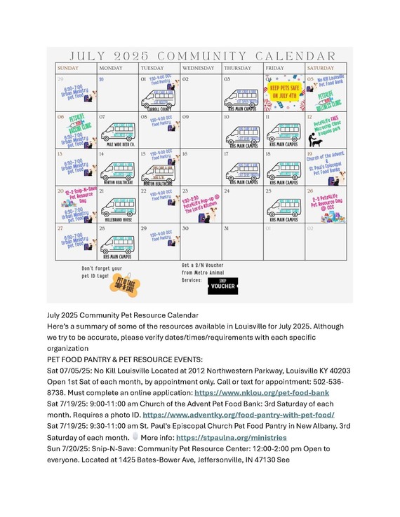
- Sgt Sassy “Sgt. Sassy may have a tough name but this girl is a total sweetheart. At 5yrs old, she was surrendered alongside 16 other pets after her caregiver lost their home and had no choice but to live in their car with their beloved animals. Despite the hardship, Sgt. Sassy has remained upbeat, resilient, and full of love. Volunteers adore her for her adorable stubby legs, cute ears, and beautiful markings. She’s a happy, social girl with excellent leash manners, a fun personality, and a big heart. She lived peacefully with both dogs and cats and would make a wonderful companion in a multi-pet household. Thanks to the BISSELL Pet Foundation, Sgt. Sassy’s adoption fee is fully waived so you can spend that money on toys, treats, and all the snuggles she’ll happily give you in return! Visit Animal House today! 3516 Newburg Rd, Louisville, KY Open daily noon–6pm Learn more & apply to adopt: com/yourcityshelter #adoptdontshop #fostermelouisville #yourcityshelter #TodayAtTheShelter”
- Matilda- There have been successful adoption stories when description of “grumpy” pets are a little “too honest.” I tried that approach for Matilda with awesome results, Matilda was featured on WDRB, WAVE, 1.6K likes pls almost 400 shares… except..she still isn’t adopted! “'Tis the season to adopt an unhinged cat and spend the rest of your life watching your back.
Matilda has had chance after chance, but she refuses to chill. Her diabolical adorableness will lure you in and then SNAP she’s back on bite quarantine.
SMH If you’re a nude homebody, proceed with caution. She sees exposed skin as an open invitation.
Matilda’s charm is buried somewhere between her many personalities. There’s no telling if she’ll like you from one day to the next but take comfort.. it’s her, not you.
ISO a brave soul to adopt this tiny menace.
If chaos is your love language, Matilda is your girl.
3516 Newburg Rd, Louisville, KY Open daily noon–6pm”

| Jefferson County |
|
| U.S. 31E (Bardstown Road) |
Traffic Impacts: Lane closures with flagging operations.
Date/Time: Nightly from 6 p.m. to 7 a.m. beginning Sunday, July 13, through Thursday, July 17.
Project Limits: U.S. 31E (Bardstown Road) between mile points 5.540 and 5.650 at Buelah Church Road, and between mile points 5.20 and 5.34 at Cedar Look Drive.
Type of Work: High-friction surface treatment. |
U.S. 31E (Main Street)
*Main Remade – East Phase |
Traffic Impacts: Sidewalk and lane closures are possible.
Date/Time: Daily.
Project Limits: U.S. 31E (Main Street) between Wenzel Street and 2nd Street.
Type of Work: One-way to two-way conversion. In addition to the new two-way configuration, other improvements coming to the corridor include upgrades to crosswalks and intersections, a protected bike lane, dedicated left-turn lanes, and new traffic signals.
Other Details: Construction phasing details are available online at: www.MainRemade.com
|
| U.S. 60 (Shelbyville Road) |
Traffic Impacts: Lane closures with flagging operations.
Date/Time: Nightly from 6 p.m. to 7 a.m. beginning Sunday, July 13, through Thursday, July 17.
Project Limits: U.S. 60 (Shelbyville Road) between mile points 10.394 and 10.485 at Evergreen Road.
Type of Work: High-friction surface treatment. |
| I-64 East |
Traffic Impacts: Lane closures with flagging operations.
Date/Time: Nightly from 6 p.m. to 7 a.m. beginning Sunday, July 13, through Thursday, July 17.
Project Limits: I-64 East off-ramp to Story Avenue.
Type of Work: High-friction surface treatment. |
| I-64 East and West |
Traffic Impacts: Single lane closures.
Date/Time: Saturday, July 12, from 9 a.m. to 12 p.m. and Sunday, July 13, from 7 a.m. to 1 p.m.
Project Limits: I-64 East and West at mile point 3.6 (near the 9th Street interchange).
Type of Work: Routine bridge inspection.
Other Details: Motorists should heed signage, use caution and expect travel delays. |
| I-64 East and West |
Traffic Impacts: Lane closures and traffic shifts are possible.
Date/Time: Daily and nightly.
Project Limits: I-64 East and West at mile point 11.799, near Exit 10 (Cannons Lane) on I-64 West, and near Exit 12 to I-264 (Watterson Expressway) on I-64 East.
Type of Work: Bridge replacement project.
Other Details: **Eastbound and westbound traffic is shifted to the outer shoulders. Construction is currently taking place in the median, and two 11-foot lanes will remain open in each direction for the duration of the project.
*Press release
|
| I-65 South (John F. Kennedy Memorial Bridge) |
Project Limits: I-65 South (John F. Kennedy Memorial Bridge).
Type of Work: Expansion joint replacement project.
Other Details: Full construction is scheduled to begin in mid-July, when newly fabricated expansion joints are expected to arrive. The project is expected to be completed by April 2026, and intermittent lane closures are to be anticipated throughout the duration of construction.
*June 3, 2025 press release
*March 31, 2025 press release
*February 27, 2025 press release
|
| I-65 South |
Traffic Impacts: Closure.
Details: Beginning at 8 p.m. Friday, July 18, and continuing through 5 a.m. Monday, July 21, crews will close the left three lanes of the John F. Kennedy Memorial Bridge, limiting access to I-65 South. Motorists should detour by continuing on I-65 South to I-64 East, I-64 West, or I-71 North. Additionally, the I-64 East and West ramps to I-65 South and the I-71 South ramp I-65 South will close beginning at 7 p.m. on Friday, July 18.
Once the interstate reopens on the morning of Monday, July 21, I-65 South will be reduced to one lane through this corridor through Wednesday, July 23, at 5 a.m., as work continues.
Additional information is available here.
|
| I-264/U.S. 42 (Brownsboro Road) Improvement Project |
*Traffic impacts here.
|
| I-265 North (Gene Snyder Freeway) |
Traffic Impacts: Closure of the left lane.
Date/Time: Beginning at 7 p.m. on Friday, July 11, through 5 a.m. on Monday, July 14.
Project Limits: I-265 North at mile point 23.1 (at the bridge over KY 155/Taylorsville Road).
Type of Work: Bridge expansion joint replacement.
Other Details: Motorists should heed signage, use caution, and plan for extended travel times. |
| KY 841 (Gene Snyder Freeway) |
Traffic Impacts: Single lane closures are possible.
Date/Time: Beginning Sunday, July 13, through Saturday, July 19.
Daily – 9 a.m. to 3 p.m. | Nightly – 7 p.m. to 5 a.m.
Project Limits: KY 841 North and South (Gene Snyder Freeway), between mile points 35.0 and 37.7, near and through the East End Tunnel.
Type of Work: Routine maintenance of the roadway and East End Tunnel.
Other Details: Motorists should heed signage, use caution, and adjust commutes to accommodate lane closures. |
| KY 864 (Logan Street/Shelby Street) |
Traffic Impacts: Sidewalk and lane closures are possible.
Date/Time: Daily and nightly.
Project Limits: Between Goss Avenue and East Gray Street.
Type of Work: One-way to two-way conversion of the roadway.
Other Details: Major work has resumed, with full completion expected by the Spring of 2026. |
| KY 1819 (Billtown Road) |
Traffic Impacts: Lane closures and delays are possible.
Date/Time: Daily – 9 a.m. to 4 p.m.
Project Limits: Three sections of KY 1819 (Billtown Road):
- Easum Road through Mary Dell Lane
- Michael Edward Drive through Fairground Road
- Shady Acres Lane through Colonnades Place
Type of Work: Reconstruction of KY 1819 (Billtown Road) from north of Colonnades Place to south of Easum Road with new traffic signals, signal optimization, turn lanes, storage lanes, etc. (varying by intersection based on existing conditions and future traffic projections).
Other Details: The reconstruction project is expected to be completed by the Summer of 2025.
*Project webpage
|
| KY 1819 (Billtown Road) |
Traffic Impacts: Lane closures with flagging operations.
Date/Time: Nightly from 6 p.m. to 7 a.m. beginning Friday, July 11, through Thursday, July 17.
Project Limits: KY 1819 (Billtown Road) between mile points 6.040 to 6.196 at Shaffer Lane, and between mile points 5.444 and 5.515 at Gellhaus Lane.
Type of Work: High-friction surface treatment. |
| KY 3077 (River Road) |
Traffic Impacts: Daily closures.
Date/Time: Daily from 9 a.m. to 3 p.m.
Project Limits: KY 3077 (River Road) will be closed in sections from 3rd Street to 7th Street. I-64 traffic will not be impacted, and drivers will still be able to take Exit 4 to 3rd Street.
Type of Work: Routine hands-on bridge inspection.
Other Details: Motorists should heed signage, use caution, and plan ahead for any potential travel delays. |
| Clark Station Road |
Traffic Impacts: Road/bridge closure.
Project Limits: Clark Station Road Bridge over Long Run Creek.
Type of Work: Bridge replacement project.
Other Details: Construction will require the full closure of the existing bridge through August 1, 2025. |
| I-64 and I-264 *Various Exit Ramps |
Traffic Impacts: Ramp narrowing with intermittent lane and shoulder closures.
Project Limits: Various interchange Exit ramps on I-64 and I-264.
Type of Work: Installation and upgrade of wrong-way pavement markings and signs.
Other Details: The Highway Safety Improvement Project will install and enhance wrong-way signs and pavement markings on interstate Exit ramps to discourage wrong-way driving. Motorists should reduce speeds and obey traffic control while workers are present. This project is expected to be completed by the Fall of 2025. |
| *Various Locations |
Traffic Impacts: Lane closures and delays are possible as part of a mobile operation.
Date/Time: Nightly – 8 p.m. 5 a.m.
Type of Work: Pavement striping.
Other Details: Motorists should provide plenty of space to crews displaying "WET PAINT" signage and be observant of slowed vehicles while traveling through the work zone. |
| |
|
| Bullitt County |
|
| I-65/KY 480 (Cedar Grove Road) |
Traffic Impacts: Changing traffic patterns, lane shifts, and lane closures are possible as construction progresses.
Date/Time: Daily and nightly.
Project Limits: KY 480 (Cedar Grove Road) between I-65 between mile points 0.6 and 1.4.
Type of Work: Reconstruction of the KY 480/I-65 interchange, including the construction of a double crossover diamond.
Other Details: The interchange reconstruction project is expected to be completed by the Fall of 2025.
|
| |
|
| Franklin County |
|
| U.S. 60 (Louisville Road) |
Traffic Impacts: Lane closures are possible.
Date/Time: Daily.
Project Limits: U.S. 60 (Louisville Road) from mile point .023 to mile point 3.89.
Type of Work: Base failure repairs ahead of an upcoming asphalt resurfacing project.
Other Details: Motorists should heed signage, use caution, and expect delays. |
| I-64/U.S. 127 Interchange |
Traffic Impacts: Lane closures and traffic shifts are possible.
Date/Time: Daily/Nightly.
Project Limits: The I-64/U.S. 127 interchange.
Type of Work: The realigning of the I-64 West off-ramp to U.S. 127 North and the I-64 West on-ramp from U.S. 127. Other improvements include the installation of a new signalized intersection on U.S. 127 to provide access to development entrances, which will be activated following project completion. Additionally, the intersection of Westridge Drive and Leonardwood Drive will be reconstructed to accommodate dual left turns onto Westridge Drive from U.S. 127.
Other Details: Traffic is now in its final configuration. The interchange reconstruction project is expected to be completed by the Summer of 2025.
*Press release
|
| U.S. 127/Vandalay Drive Intersection |
Traffic Impacts: Lane closures and traffic shifts are possible.
Date/Time: Daily/nightly.
Project Limits: U.S. 127/Vandalay Drive intersection.
Type of Work: The scope of the project includes constructing a new roundabout at the intersection of Vandalay Drive and Westridge Drive; extending Vandalay Drive to Limestone Drive to create a direct connection to KY 676 (East-West Connector); extending Vandalay Drive to U.S. 127 near the I-64/U.S. 127 interchange; and adding dual receiving lanes to improve left-turn movements from U.S. 127 onto Westridge Drive.
Other Details: The project is scheduled to be completed by the summer of 2026. |
| KY 1005 (Devils Hollow Road) |
Traffic Impacts: Closure
Date/Time: Beginning Thursday, July 10, through Monday, Aug. 11.
Project Limits: KY 1005 (Devils Hollow Road) at mile point 2.2.
Type of Work: Bridge maintenance.
Other Details: Motorists should expect to follow signed detours along the affected area while work is underway. |
| KY 1665 (Bridgeport-Benson Road) |
Traffic Impacts: Closure.
Date/Time: Beginning Monday, July 7, through Sunday, September 7.
Project Limits: KY 1665 (Bridgeport-Benson Road) bridge over South Benson Creek at mile point 3.93.
Type of Work: Bridge replacement. |
| |
|
| Oldham County |
|
| KY 329 |
Traffic Impacts: Closure.
Date/Time: Beginning Thursday, July 10, at 9 a.m.
Project Limits: KY 329 will be closed from mile point 1.491 (near Eagle Lane) to mile point 2.1 (near Hidden Springs Lane).
Type of Work: Cross drain replacement.
Other Details: Following the replacement of the cross drain, crews will place a layer of dense-grade rock over it until asphalt can be laid. Drivers should exercise caution when driving over the newly replaced cross drain.
*The closure will remain in place until KYTC crews complete work to replace the cross drain. At this time, the full scope of repairs and the time needed to complete them are still unclear. We expect to have a better estimate for how long the closure will last once crews begin excavation and will provide an update when one is available.* |
| |
|
| Spencer County |
*Routine maintenance* |
| |
|
| Shelby County |
|
| I-64 Widening and Improvement Project |
*Traffic impacts here.
|
| U.S. 60 (Frankfort Road) |
Traffic Impacts: Lane closures are possible.
Date/Time: Daily.
Project Limits: U.S. 60 (Frankfort Road) from mile point 19.338 at KY 395 to mile point 23.0 at the Franklin/Shelby County line.
Type of Work: Base failure repairs ahead of an upcoming asphalt resurfacing project.
Other Details: Motorists should heed signage, use caution, and expect delays. |
| *Various Locations |
Traffic Impacts: Lane closures and delays are possible as part of a mobile operation.
Date/Time: Daily – 7 a.m. to 11 p.m.
Type of Work: Pavement striping.
Other Details: Motorists should provide plenty of space to crews displaying "WET PAINT" signage and be observant of slowed vehicles while traveling through the work zone. |
| |
|
| Henry County |
*Routine maintenance* |
| |
|
| Trimble County |
*Routine maintenance* |
| 2025 Resurfacing Projects |
*Resurfacing projects will begin on or after April 1, 2025, and will be completed by the Fall of 2025. Motorists should heed signage and use caution when traveling through the work zone.* |
| |
|
| Jefferson County |
|
KY 2830 (Arthur Street)
*Completed* |
Project Limits:
KY 2830 (Arthur Street) east of Brandies Avenue/KY 61 extending north to University Boulevard. |
U.S. 31E (Bardstown Road)
*Completed* |
Project Limits:
U.S. 31E (Bardstown Road) at the Bullitt/Jefferson County line, extending south of Colonel Hancock Drive. |
KY 1631 (Crittenden Drive)
*Completed* |
Project Limits:
KY 1631 (Crittenden Drive) at the beginning of state maintenance near the I-264 interchange, extending north to U.S. 60A (Eastern Parkway). |
KY 1531 (Johnson Road)
*Completed* |
Project Limits:
KY 1531 (Johnson Road) from the railroad crossing extending north to Aiken Road. |
KY 61 (Arthur Street)
*Completed* |
Project Limits:
KY 61 (Arthur Street) beginning east of Brandies Avenue extending north to I-65 ramp/East Gaulbert Avenue. |
KY 155 (Taylorsville Road)
*Completed* |
Project Limits:
KY 155 (Taylorsville Road) beginning at KY 1747 (Hurstbourne Lane) extending north to KY 1932 (Breckenridge Lane). |
KY 329 (Covered Bridge Road)
*Completed* |
Project Limits:
KY 329 (Covered Bridge Road) beginning at U.S. 42 extending east to the Jefferson/Oldham County line. |
| |
|
| Bullitt County |
|
KY 1531 (Dawson Hill Road)
*Completed* |
Project Limits:
KY 1531 (Dawson Hill Road) from KY 1319 extending north to the Bullitt/Jefferson County line. |
KY 2672 (Knob Creek Road)
*Completed* |
Project Limits:
KY 2672 (Knob Creek Road) from KY 1526 (Brooks Hill Road) extending north towards Lake Elmo Road. |
KY 2674 (Stringer Lane)
*Completed* |
Project Limits:
KY 2674 (Stringer Lane) from U.S. 31E extending north to KY 44. |
| |
|
| Franklin County |
|
| KY 12 (Dry Ridge Road/Flat Creek Road) |
Project Limits:
KY 12 (Dry Ridge Road/Flat Creek Road) from the Shelby/Franklin County line extending east to Harvieland Road. |
| KY 1570 (St Johns Road) |
Project Limits:
KY 1570 (St Johns Road) from the bridge at mile point 4.2, extending north to KY 12. |
| U.S. 127 (Wilkinson Boulevard) |
Project Limits:
U.S. 127 (Wilkinson Boulevard) near Hall Street extending north to the south end of the U.S. 127/KY 2261 bridge. |
| |
|
| Oldham County |
|
| KY 362 (Central Avenue) |
Project Limits:
KY 362 (Central Avenue) from Rosswoods Drive extending south towards KY 146. |
KY 329 (Covered Bridge Road)
*Completed* |
Project Limits:
KY 329 (Covered Bridge Road) from KY 329B extending east to mile point 8.754. |
| KY 1694 (Gum Street) |
Project Limits:
KY 1694 (Gum Street) from KY 329 extending north towards Mason Lane. |
U.S. 42
*Completed*
|
Project Limits:
U.S. 42 east of KY 1694 (Gum Street) extending east to the Oldham/Henry County line. |
| |
|
| Shelby County |
|
KY 362 (Aiken Road)
*Completed* |
Project Limits:
KY 362 (Aiken Road) from the Oldham/Shelby County line extending east near Webb Road. |
| U.S. 60 (Frankfort Road) |
Project Limits:
U.S. 60 (Frankfort Road) beginning at KY 395 extending east to the Shelby/Franklin County line. |
KY 1408 (Loydsburg Road)
*Completed* |
Project Limits:
KY 1408 (Loydsburg Road) from KY 362 extending west to the Shelby/Oldham County line. |
KY 322 (Lucas Road)
*Completed* |
Project Limits:
KY 322 (Lucas Road) from KY 53 extending north to the Shelby/Henry County line. |
| KY 53 (Mt. Eden Road) |
Project Limits:
KY 53 (Mt. Eden Road) beginning at KY 714/KY 44 extending north to KY 1790 (Hooper Station Road). |
| |
|
| Spencer County |
|
KY 1633 (Elk Creek Road)
*Completed* |
Project Limits:
KY 1633 (Elk Creek Road) from KY 1135 (Industrial Road) extending north to KY 55.
|
KY 1795 (Mill Road)
*Completed* |
Project Limits:
KY 1795 (Mill Road) from Paradise Pointe Road extending east to KY 636. |
KY 55 (Shelbyville Road)
*Completed* |
Project Limits:
KY 55 (Shelbyville Road) beginning at KY 155 extending north to the Spencer/Shelby County line. |
| |
|
| Henry County |
|
U.S. 421 (Campbellsburg Road)
*Completed*
|
Project Limits:
U.S. 421 (Campbellsburg Road) at the I-71 overpass extending to the Henry/Trimble County line. |
KY 1360 (Franklinton Road)
*Completed* |
Project Limits:
KY 1360 (Franklinton Road) from KY 22 extending north to Bullitt Hill Road.
|
KY 241 (Pleasureville Road)
*Completed*
|
Project Limits:
KY 241 (Pleasureville Road) beginning at the Shelby/Henry County line extending north to U.S. 421. |
KY 1861 (Smithfield Road)
*Completed* |
Project Limits:
KY 1861 (Smithfield Road) from KY 22 extending to KY 322. |
| |
|
| Trimble County |
|
KY 1256 (Fisher Ridge Road)
*Completed* |
Project Limits:
KY 1256 (Fisher Ridge Road) from Detmer Lane extending east to KY 625. |
KY 3175 (Sulphur-Bedford Road)
*Completed* |
Project Limits:
KY 3175 (Sulphur-Bedford Road) from Hoskins Lane extending north to U.S. 42. |
We now have a new way for you to map crime around you. Just click here and view our new interactive crime mapping tool for Division 5 & 8 or for each beat in Division 5 & 8. And save it in your favorites to view crime anytime it's updated daily. On the page is a Quickfind tool that allows you to put your address in and subscribe to crime trends, alerts and block watch reports for your police beat. Forward this email to your friends and family!
For further information on Councilman Scott Reed or District 16 please visit www.louisvilleky.gov/government/metro-council-district-16
You can also reach out directly by phone at 502.574.1116 or by email at scott.reed@louisvilleky.gov.
601 West Jefferson Street
Louisville, KY 40202
Having Trouble Viewing this eNewsletter? Click here to view it on the web.
|


