
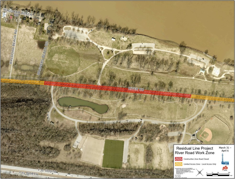
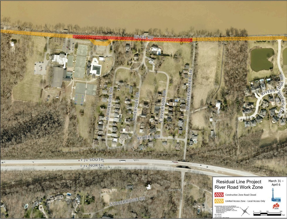
*Note: Cleanup from last week’s flooding is complete which allows us to resume construction. Please follow the detours and access routes listed below.
We currently have two active work zones – one just east of the entrance to Louisville Turners, Waldoah Beach Road, and Wagners Beach Road; and a second one near the Louisville Boat Club and the intersection of River Road and Blankenbaker Lane.
- If you are trying to access Thurman-Hutchins Park, Cox Park, Different Strokes, Louisville Islamic Center, or Louisville Boat Club, please access River Road from Indian Hills Trail.
- If you are trying to access River Road west of Louisville Turners, please use River Road at Zorn Avenue or Mockingbird Valley Road. To access Louisville Turners, Waldoah Beach Road, or Wagners Beach Road from River Road, use Zorn Avenue or Mockingbird Valley Road.
- If you are trying to access the Riviera Neighborhood (Riverside Drive, West Riverside Drive, East Riverside Drive, Riviera Drive), please use Blankenbaker Lane.
Residual Line Project - Louisville Water Company
 River Road at Cox Park
 River Road at Blankenbaker Lane
Safety:
We urge everyone to stay away from downed wires and to keep others and pets away too. People should always assume a downed wire is an energized line. We urge customers to report any downed wires immediately. If the situation is an emergency, they should call 911. In non-emergency situations they may call LG&E at 502-589-1444 (fast path 1-1-3). Customers should also remain cautious when clearing fallen tree limbs and debris from their yard and avoid contacting any branches or debris that may be in direct contact with a power line.
Restoration process:
During and after storms, LG&E’s service restoration takes place through a prioritization process that involves several different layers. While we work to restore all customers’ service in the field, we will also use our ability to reroute power, where we can, from our control center, coupled with automated controls installed on our system, to limit the number of customers affected. Procedure as follows:
- First, we respond to emergency situations, reports of downed wires and unsafe conditions.
- Next, we will begin restoration of critical services in our community - hospitals, fire and police stations, airports, and nursing homes.
- Then, we restore outage events with the highest number of customers, which will bring back service as safely and quickly as possible.
- Next, we repair any damaged equipment. Whenever possible, temporary repairs are made to restore power quickly and allow time for longer repairs to take place.
- For customers still without power, crews then make repairs to the individual power lines and service lines that feed directly to customers’ individual homes and businesses.
- LG&E will continue to update estimated restoration times based on crews’ feedback in the field and the level of damage our crews are finding at customers’ properties. Customers are encouraged to continue checking their status by visiting https://stormcenter.lge-ku.com/ or by utilizing our mobile APP.
Our crews and partners will be in the field safely working around the clock on all aspects of the restoration effort. They are protecting the public, assessing, and repairing damage and restoring power to the communities we are proud to serve.
In the beginning of a large-scale power outage, sometimes up to 24 hours or more depending on the severity of the storm, it may appear LG&E is not doing anything, but in actuality, our crews are out assessing damage to our system. We must first assess the totality of the outage before we begin to repair. Assessment may involve inspecting substations/equipment and include our employees walking/driving the transmission/distribution lines where an outage has occurred and physically finding the problem, trees/equipment, etc. As you can imagine, we have over 3,400 miles of overhead lines in Jefferson County, so this takes a good amount of time.
 |

 Join specialists from Norton Neuroscience Institute Memory Center to raise awareness about Alzheimer's disease and celebrate progress in treating it. During this lunch program, learn about the memory center and the latest treatment options, and celebrate the community of caregivers who support our patients with memory disorders. Guests are encouraged to wear Derby hats and attire.
Tuesday, April 29th 11:00am-1:30pm EST
Crown Plaza Hotel 830 Phillips Lane
To Register, click HERE or call 502.629.1234 (option 4)


EGGsplore the Zoo with an EGGcelent scavenger hunt game that allows you to search for hidden zoo-themed eggs, answer trivia questions, and compete in challenges and earn points to win a free Louisville Zoo membership, plush animals, and more. The Safari EGGventure is free with Louisville Zoo admission or membership.
-
To participate follow these steps: Using your camera-enabled smartphone or tablet, download the free GooseChase app. Enter join code “W2FL3F” and join the game. Find hidden eggs, answer trivia questions, and complete other challenges during your visit. Each correct answer will earn points. Score 500 or more points to be entered to win a prize. Prize winners will be drawn at random at the conclusion of the event. Winners will be notified of their prize winnings on, or before, April 30.

Construction activities scheduled for the next month include:
- Work continues on the water tank next to the water tower
- Work is scheduled to begin on paving roads on the south end of the construction site soon.
- Work continues on the guard shack near the entrance of the construction site.
- Drywall, insulation and paint are being installed in the West Bar of the medical facility.
- Interior framing and utility rough in is taking place in the East and West Bars of the medical facility.
- Work on the loading dock and laundry facility on the west side of the medical facility continues.
- Utilities and equipment installation at the Central Utility Plant continues, as well as exterior masonry.
- Exterior metal wall framing continues on the West Bar of the medical facility.
- Utility and elevator installation continue in the North Parking Structure.
- The installation of photovoltaic (solar) panels continues at the North Parking Structure.
Work continues on both the Eastern Electrical Building near the USACE trailer and the Western Electrical Building just north of the North Parking Structure.
New items or changes in project status are shown in bold
Inclement weather or other unforeseen circumstances may arise, and as such, the information provided below is for advisory purposes only and subject to change without prior notice.
| I-Move KY |
|
| I-265 (Gene Snyder Freeway) |
- Beginning Monday, March 31, at 9 a.m., through approximately Wednesday, April 30.
- I-265 North (Gene Snyder Freeway) will be reduced to two lanes at mile marker 29 (near KY 3084/Old Henry Road).
|
| Jefferson County |
|
| I-64 East and West |
Traffic Impacts: Lane and shoulder closures are possible.
Date/Time: Daily and nightly.
*Major work will begin in mid-May.
Project Limits: I-64 East and West at mile point 11.799, near Exit 10 (Cannons Lane) on I-64 West, and near Exit 12 to I-264 (Watterson Expressway) on I-64 East.
Type of Work: Bridge replacement project.
Other Details: ***As a necessary safety precaution, the right lane of I-64 East is currently closed at the bridge over the Middle Fork of Beargrass Creek at mile point 11.799 (near Exit 12 to I-264/Watterson Expressway) due to bridge deck damage. Contract crews will perform temporary repairs ahead of a larger bridge replacement project that began in early March.
|
| I-64 East |
Traffic Impacts: Closure of the right lane.
Date/Time: Daily from 9 a.m. to 3 p.m. and nightly from 6 p.m. to 10 p.m. beginning Monday, April 21, through Wednesday, April 23.
Project Limits: I-64 East from mile marker 8 (near U.S. 60A/Lexington Road) to mile marker 10 (near KY 2048/Cannons Lane).
Type of Work: Routine maintenance of the highway.
Other Details: Motorists should heed signage and use caution when traveling through the work zone.
|
| I-64 West |
Traffic Impacts: Closure of the left two lanes.
Date/Time: Daily from 9 a.m. to 3 p.m. on Tuesday, April 22, and Thursday, April 24.
Project Limits: I-64 West from mile marker 20 (near the I-265/I-64 interchange) to mile marker 12 (near the I-264/I-64 interchange).
Type of Work: Crews will be conducting core drilling for pavement samples.
Other Details: Motorists should heed signage and use caution when traveling through the work zone.
|
| I-65 South (John F. Kennedy Memorial Bridge) |
Date/Time: Once expansion joints have been fabricated as part of the expansion joint replacement project, additional details regarding the project's timing will be shared.
Project Limits: I-65 South (John F. Kennedy Memorial Bridge).
Other Details: The project is expected to be completed by April 2026, and intermittent lane closures are to be anticipated throughout the duration of construction.
|
| KY 841 North and South (Gene Snyder Freeway) |
Traffic Impacts: Single lane closures are possible.
Date/Time: Beginning Monday, April 14, through Saturday, April 19.
Daily – 9 a.m. to 3 p.m. | Nightly – 7 p.m. to 5 a.m.
Project Limits: KY 841 North and South (Gene Snyder Freeway), between mile points 35.0 and 37.7, near and through the East End Tunnel.
Type of Work: Routine maintenance of the roadway and East End Tunnel.
Other Details: Motorists should heed signage, use caution, and adjust commutes to accommodate the lane closures.
|
| KY 864 (Logan Street/Shelby Street) |
Traffic Impacts: Sidewalk and lane closures are possible.
Date/Time: Daily and nightly.
Project Limits: Between Goss Avenue and East Gray Street.
Type of Work: One-way to two-way conversion of the roadway.
Other Details: Work is underway ahead of asphalt resurfacing and the two-way conversion of the roadway.
*Work was temporarily paused on this project as KYTC engineers coordinated with contractors to reduce utility conflicts along the corridor. Major work is expected to resume this Spring, with full completion expected by the Spring of 2026.
|
| KY 1531 (Johnson Road) |
Traffic Impacts: Single lane closures with flagging measures are possible.
Date/Time: Daily from 9 a.m. to 3 p.m. beginning Monday, March 31.
Project Limits: KY 1531 (Johnson Road) from the railroad crossing on KY 1531, extending north to Aiken Road (from mile point 9.799 to mile point 11.789).
Type of Work: Base failure repairs ahead of asphalt resurfacing project.
|
| KY 1819 (Billtown Road) |
Traffic Impacts: Lane closures and delays are possible.
Date/Time: Daily – 9 a.m. to 4 p.m.
Project Limits: Three sections of KY 1819 (Billtown Road):
- Easum Road through Mary Dell Lane
- Michael Edward Drive through Fairground Road
- Shady Acres Lane through Colonnades Place
Type of Work: Reconstruction of KY 1819 (Billtown Road) from north of Colonnades Place to south of Easum Road with new traffic signals, signal optimization, turn lanes, storage lanes, etc. (varying by intersection based on existing conditions and future traffic projections).
Other Details: The reconstruction project is expected to be completed by the Summer of 2025.
*Project webpage
|
| KY 3084 (Old Henry Road) |
Traffic Impacts: Traffic will be reduced to one lane and shifted into the median.
Project Limits: KY 3084 (Old Henry Road) from Woodmont Park Lane to Old Henry Trail.
Type of Work: Corrective work.
Other Details: Traffic impacts are expected to remain until the work is completed. Motorists should heed signage and use caution when traveling through the work zone.
|
| Clark Station Road |
Traffic Impacts: Road/bridge closure.
Project Limits: Clark Station Road Bridge over Long Run Creek.
Type of Work: Bridge replacement project.
Other Details: Construction will require the full closure of the existing bridge through August 1, 2025.
|
| *Various Locations |
Traffic Impacts: Lane closures and delays are possible as a part of a mobile operation.
Date/Time: Overnight hours from 7 p.m. to 6 a.m.
Type of Work: Pavement marker (reflector) replacement and installation.
Other Details: Motorists should be observant of all road work signage and provide plenty of space for slow moving vehicles while traveling through the work zone.
|
| |
|
| Bullitt County |
|
| I-65/KY 480 (Cedar Grove Road) |
Traffic Impacts: Changing traffic patterns, lane shifts, and lane closures are possible as construction progresses.
Date/Time: Daily and nightly.
Project Limits: KY 480 (Cedar Grove Road) between I-65 between mile points 0.6 and 1.4.
Other Details: The interchange reconstruction project is expected to be completed by the Fall of 2025.
|
| *Various Locations |
Traffic Impacts: Lane closures and delays are possible as a part of a mobile operation.
Date/Time: Overnight hours from 7 p.m. to 6 a.m.
Type of Work: Pavement marker (reflector) replacement and installation.
Other Details: Motorists should be observant of all road work signage and provide plenty of space for slow moving vehicles while traveling through the work zone.
|
| I-65 *Various Exit Ramps |
Traffic Impacts: Intermittent lane and ramp closures.
Date/Time: Nightly – 8 p.m. to 6 a.m. | Daily – 9 a.m. to 3 p.m.
Project Limits: Various interchange Exit ramps on I-65.
Type of Work: Upgrade and install wrong way pavement markings and signs.
Other Details: The Highway Safety Improvement Project will install and enhance wrong way signs and pavement markings on various interstate exit ramps to discourage wrong way driving. Motorists should reduce speeds and obey traffic control while workers are present. This project is set to be completed by the fall of 2025.
|
| |
|
| Franklin County |
|
| I-64/U.S. 127 Interchange |
Traffic Impacts: Lane closures and traffic shifts are possible.
Date/Time: Nightly.
Project Limits: The I-64/U.S. 127 interchange.
Type of Work: The realigning of the I-64 West off-ramp to U.S. 127 North and the I-64 West on-ramp from U.S. 127. Other improvements include the installation of a new signalized intersection on U.S. 127 to provide access to development entrances, which will be activated following project completion. Additionally, the intersection of Westridge Drive and Leonardwood Drive will be reconstructed to accommodate dual left turns onto Westridge Drive from U.S. 127.
Other Details: Traffic is now in its final configuration. The interchange reconstruction project is expected to be completed by the Summer of 2025.
*Press release
|
| U.S. 421 (Bald Knob Road) |
Traffic Impacts: Nightly road closures.
Date/Time: Nightly from 6 p.m. to midnight beginning Monday, March 24, through Monday, April 7.
Project Limits: U.S. 421 (Bald Knob Road) to KY 1570 (St Johns Road).
Type of Work: Base failure repairs and cross drain replacements ahead of an upcoming resurfacing project.
Other Details: Motorists should follow posted detours around the affected area while work is underway.
|
| *Various Locations |
Traffic Impacts: Lane closures and delays are possible as a part of a mobile operation.
Date/Time: Overnight hours from 7 p.m. to 6 a.m.
Type of Work: Pavement marker (reflector) replacement and installation.
Other Details: Motorists should be observant of all road work signage and provide plenty of space for slow moving vehicles while traveling through the work zone.
|
| I-64 *Various Exit Ramps |
Traffic Impacts: Intermittent lane and ramp closures.
Date/Time: Nightly – 8 p.m. to 6 a.m. | Daily – 9 a.m. to 3 p.m.
Project Limits: Various interchange Exit ramps on I-64.
Type of Work: Upgrade and install wrong way pavement markings and signs.
Other Details: The Highway Safety Improvement Project will install and enhance wrong way signs and pavement markings on various interstate exit ramps to discourage wrong way driving. Motorists should reduce speeds and obey traffic control while workers are present. This project is set to be completed by the fall of 2025.
|
| |
|
| Oldham County |
|
| I-71 *Various Exit Ramps |
Traffic Impacts: Intermittent lane and ramp closures.
Date/Time: Nightly – 8 p.m. to 6 a.m. | Daily – 9 a.m. to 3 p.m.
Project Limits: Various interchange Exit ramps on I-71.
Type of Work: Upgrade and install wrong way pavement markings and signs.
Other Details: The Highway Safety Improvement Project will install and enhance wrong way signs and pavement markings on various interstate exit ramps to discourage wrong way driving. Motorists should reduce speeds and obey traffic control while workers are present. This project is set to be completed by the fall of 2025.
|
| |
|
| Spencer County |
|
| KY 1392 (Grays Run Road) |
Traffic Impacts: Daily and nightly road closures.
Date/Time: Daily from 9 a.m. to 2 p.m. | Nightly from 6 p.m. to 12 a.m. beginning Tuesday, April 8, through Wednesday, April 30.
Project Limits: KY 1392 (Grays Run Road) from mile point 2.0 to mile point 4.5. *Crews will work in sections.*
Type of Work: Cross drain replacements ahead of an upcoming resurfacing project.
Other Details: Following the replacement of the cross drains, crews will place a layer of dense-grade rock over it until asphalt can be laid. Drivers should exercise caution when driving over the newly replaced cross drains.
|
| *Various Locations |
Traffic Impacts: Lane closures and delays possible as a part of a mobile operation.
Date/Time: Daily – 7 a.m. to 9 p.m.
Type of Work: Pavement striping.
Other Details: Motorists should provide plenty of space to crews displaying "WET PAINT" signage and be observant of slowed vehicles while traveling through the work zone.
|
| |
|
| Shelby County |
|
| I-64 Widening and Improvement Project |
|
| KY 53 (Mt. Eden Road) |
Traffic Impacts: Road closure.
Date/Time: Beginning Monday, April 14, at 7:30 a.m. through Friday, May 2.
Project Limits: KY 53 (Mt. Eden Road) from mile point 1.62 at Lisby Lane to mile point 2.4.
Type of Work: Routine maintenance of the roadway, including base failure repairs, slope protection measures, and cross drain replacements.
|
| *Various Locations |
Traffic Impacts: Lane closures and delays are possible as a part of a mobile operation.
Date/Time: Overnight hours from 7 p.m. to 6 a.m.
Type of Work: Pavement marker (reflector) replacement and installation.
Other Details: Motorists should be observant of all road work signage and provide plenty of space for slow moving vehicles while traveling through the work zone.
|
| I-64 *Various Exit Ramps |
Traffic Impacts: Intermittent lane and ramp closures.
Date/Time: Nightly – 8 p.m. to 6 a.m. | Daily – 9 a.m. to 3 p.m.
Project Limits: Various interchange Exit ramps on I-64.
Type of Work: Upgrade and install wrong way pavement markings and signs.
Other Details: The Highway Safety Improvement Project will install and enhance wrong way signs and pavement markings on various interstate exit ramps to discourage wrong way driving. Motorists should reduce speeds and obey traffic control while workers are present. This project is set to be completed by the fall of 2025.
|
| |
|
| Henry County |
|
| I-71 *Various Exit Ramps |
Traffic Impacts: Intermittent lane and ramp closures.
Date/Time: Nightly – 8 p.m. to 6 a.m. | Daily – 9 a.m. to 3 p.m.
Project Limits: Various interchange Exit ramps on I-71.
Type of Work: Upgrade and install wrong way pavement markings and signs.
Other Details: The Highway Safety Improvement Project will install and enhance wrong way signs and pavement markings on various interstate exit ramps to discourage wrong way driving. Motorists should reduce speeds and obey traffic control while workers are present. This project is set to be completed by the fall of 2025.
|
| |
|
| Trimble County |
*Routine maintenance |
| 2025 Resurfacing Projects |
*Resurfacing projects will begin on or after April 1, 2025, and will be completed by the Fall of 2025. Motorists should heed signage and use caution when traveling through the work zone.* |
| |
|
| Jefferson County |
|
| KY 2830 (Arthur Street) |
Project Limits:
KY 2830 (Arthur Street) east of Brandies Avenue/KY 61 extending north to University Boulevard.
|
| U.S. 31E (Bardstown Road) |
Project Limits:
U.S. 31E (Bardstown Road) at the Bullitt/Jefferson County line, extending south of Colonel Hancock Drive.
|
|
KY 1631 (Crittenden Drive)
*Completed*
|
Project Limits:
KY 1631 (Crittenden Drive) at the beginning of state maintenance near the I-264 interchange, extending north to U.S. 60A (Eastern Parkway).
|
| KY 1531 (Johnson Road) |
Project Limits:
KY 1531 (Johnson Road) from the railroad crossing extending north to Aiken Road.
|
|
KY 61 (Arthur Street)
*Completed*
|
Project Limits:
KY 61 (Arthur Street) beginning east of Brandies Avenue extending north to I-65 ramp/East Gaulbert Avenue.
|
| KY 155 (Taylorsville Road) |
Project Limits:
KY 155 (Taylorsville Road) beginning at KY 1747 (Hurstbourne Lane) extending north to KY 1932 (Breckenridge Lane).
|
| KY 329 (Covered Bridge Road) |
Project Limits:
KY 329 (Covered Bridge Road) beginning at U.S. 42 extending east to the Jefferson/Oldham County line.
|
| |
|
| Bullitt County |
|
| KY 1531 (Dawson Hill Road) |
Project Limits:
KY 1531 (Dawson Hill Road) from KY 1319 extending north to the Bullitt/Jefferson County line.
|
| KY 2672 (Knob Creek Road) |
Project Limits:
KY 2672 (Knob Creek Road) from KY 1526 (Brooks Hill Road) extending north towards Lake Elmo Road.
|
| KY 2674 (Stringer Lane) |
Project Limits:
KY 2674 (Stringer Lane) from U.S. 31E extending north to KY 44.
|
| |
|
| Franklin County |
|
| KY 12 (Dry Ridge Road/Flat Creek Road) |
Project Limits:
KY 12 (Dry Ridge Road/Flat Creek Road) from the Shelby/Franklin County line extending east to Harvieland Road.
|
| KY 1570 (St Johns Road) |
Project Limits:
KY 1570 (St Johns Road) from the bridge at mile point 4.2, extending north to KY 12.
|
| U.S. 127 (Wilkinson Boulevard) |
Project Limits:
U.S. 127 (Wilkinson Boulevard) near Hall Street extending north to the south end of the U.S. 127/KY 2261 bridge.
|
| |
|
| Oldham County |
|
| KY 362 (Central Avenue) |
Project Limits:
KY 362 (Central Avenue) from Rosswoods Drive extending south towards KY 146.
|
| KY 329 (Covered Bridge Road) |
Project Limits:
KY 329 (Covered Bridge Road) from KY 329B extending east to mile point 8.754.
|
| KY 1694 (Gum Street) |
Project Limits:
KY 1694 (Gum Street) from KY 329 extending north towards Mason Lane.
|
| U.S. 42 |
Project Limits:
U.S. 42 east of KY 1694 (Gum Street) extending east to the Oldham/Henry County line.
|
| |
|
| Shelby County |
|
| KY 362 (Aiken Road) |
Project Limits:
KY 362 (Aiken Road) from the Oldham/Shelby County line extending east near Webb Road.
|
| U.S. 60 (Frankfort Road) |
Project Limits:
U.S. 60 (Frankfort Road) beginning at KY 395 extending east to the Shelby/Franklin County line.
|
| KY 1408 (Loydsburg Road) |
Project Limits:
KY 1408 (Loydsburg Road) from KY 362 extending west to the Shelby/Oldham County line.
|
| KY 322 (Lucas Road) |
Project Limits:
KY 322 (Lucas Road) from KY 53 extending north to the Shelby/Henry County line.
|
| KY 53 (Mt. Eden Road) |
Project Limits:
KY 53 (Mt. Eden Road) beginning at KY 714/KY 44 extending north to KY 1790 (Hooper Station Road).
|
| |
|
| Spencer County |
|
| KY 1633 (Elk Creek Road) |
Project Limits:
KY 1633 (Elk Creek Road) from KY 1135 (Industrial Road) extending north to KY 55.
|
|
KY 1795 (Mill Road)
*Completed*
|
Project Limits:
KY 1795 (Mill Road) from Paradise Pointe Road extending east to KY 636.
|
| KY 55 (Shelbyville Road) |
Project Limits:
KY 55 (Shelbyville Road) beginning at KY 155 extending north to the Spencer/Shelby County line.
|
| |
|
| Henry County |
|
| U.S. 421 (Campbellsburg Road) |
Project Limits:
U.S. 421 (Campbellsburg Road) at the I-71 overpass extending to the Henry/Trimble County line.
|
| KY 1360 (Franklinton Road) |
Project Limits:
KY 1360 (Franklinton Road) from KY 22 extending north to Bullitt Hill Road.
|
| KY 241 (Pleasureville Road) |
Project Limits:
KY 241 (Pleasureville Road) beginning at the Shelby/Henry County line extending north to U.S. 421.
|
| |
|
| Trimble County |
|
| KY 1256 (Fisher Ridge Road) |
Project Limits:
KY 1256 (Fisher Ridge Road) from Detmer Lane extending east to KY 625.
|
| KY 3175 (Sulphur-Bedford Road) |
Project Limits:
KY 3175 (Sulphur-Bedford Road) from Hoskins Lane extending north to U.S. 42.
|
We now have a new way for you to map crime around you. Just click here and view our new interactive crime mapping tool for Division 5 & 8 or for each beat in Division 5 & 8. And save it in your favorites to view crime anytime it's updated daily. On the page is a Quickfind tool that allows you to put your address in and subscribe to crime trends, alerts and block watch reports for your police beat. Forward this email to your friends and family!
For further information on Councilman Scott Reed or District 16 please visit www.louisvilleky.gov/government/metro-council-district-16
You can also reach out directly by phone at 502.574.1116 or by email at scott.reed@louisvilleky.gov.
601 West Jefferson Street
Louisville, KY 40202
Having Trouble Viewing this eNewsletter? Click here to view it on the web.
|