
Public invited to review and comment on preliminary roadway designs
LOUISVILLE, Ky. (March 12, 2025) – The Kentucky Transportation Cabinet (KYTC) will hold a public meeting Thursday, April 10, to update residents and gather input on preliminary designs for the KY 2050 (Herr Lane) improvement project in Jefferson County.
The highway improvement project will improve mobility and vehicular access and enhance safety while upgrading pedestrian facilities along the corridor from the KY 2050 (Herr Lane) and KY 1447 (Westport Road) intersection to Glen Arbor Road. The proposed design includes widening KY 2050 (Herr Lane) and incorporating pedestrian amenities to accommodate all roadway users.
The meeting will be an open house event held from 5 to 7 p.m. at Kammerer Middle School, 7315 Wesboro Road, 40222. Those who are interested may drop in at any time to review the preliminary designs, receive handouts containing project information, and fill out comment sheets. Representatives from KYTC and the engineering design consultant will be in attendance to answer questions.
Following the public meeting, an online survey will be available. After considering public feedback, the final design phase will take place over the next year.
All written comments will become part of the official meeting record. Once compiled, the meeting record and supporting documentation will be made available for review and copying only after an Open Records Request has been received and approved. All Open Records Requests must be submitted to the Transportation Cabinet, Office of Legal Services, Transportation Office Building (200 Metro St, Frankfort, KY 40622), or via kytc.openrecords@ky.gov.

We need your help reporting potholes, use one of the methods below:
- Use an online form by clicking here.
- Use Twitter by sending the location of the hole to @LouMetro311 and include the hashtag #502pothole.
- Call Metro311 or 574- to report potholes or any other issues.
- Email our office at "Jared.Townes@louisvilleky.gov", and we'll turn it in on your behalf.
* When making your report make sure you have an address nearest to the pothole location or a cross street.*
|
 The annual pothole blitz will kick off Thursday, March 6! We are seeing exponentially more potholes right now than we typically have in the past several years because of record breaking amounts of snow fall and freezing for an extended period this snow season. We are prioritizing filling pot holes on major roadways (high volume/high speed – like Shelbyville road and Dixie Hwy), roadways that have excessive potholes, and responding to potholes submitted to 311.
Please be vigilant when driving:
-
Stay Alert! Keep an eye on the road ahead and watch for potholes.
-
Maintain a Safe Distance. Leave enough space between you and the car ahead so you have time to react to potholes.
- 3. Slow Down! If you can’t avoid a pothole, reduce your speed before hitting it. Hitting a pothole at high speed increases the impact force.
-
Avoid Sudden Braking. Braking hard just before hitting a pothole can push the front of your car down, making the impact worse.
-
Keep Tires Properly Inflated. Underinflated or overinflated tires are more vulnerable to damage. Check your tire pressure regularly.
Report a pothole through Metro311. Choose "Pothole" and enter the address along with a description if needed.
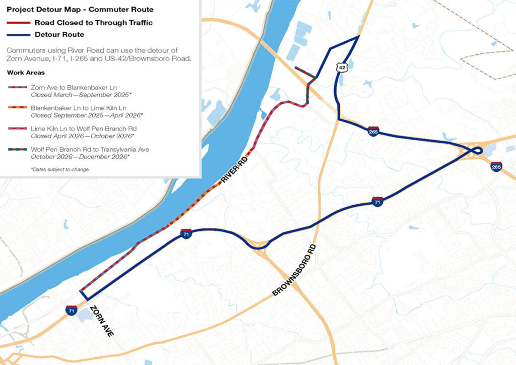
As a reminder, Louisville Water Company's contractor is starting their Residual Line Project on River Road next Monday, March 10. The first construction area is on River Road between Zorn and Blankenbaker. Below is a link to their website that provides a description of the project and provides detour information.
https://louisvillewater.com/residuallineproject/
New items or changes in project status are shown in bold
Inclement weather or other unforeseen circumstances may arise, and as such, the information provided below is for advisory purposes only and subject to change without prior notice.
| I-Move KY |
|
| I-265 (Gene Snyder Freeway) |
Traffic Impacts: Lane closures.
Date/Time: From 8 p.m. on Friday, March 21, through 6 a.m. on Monday, March 24.
Project Limits: I-265 (Gene Snyder Freeway) at mile point 25.4 (at the bridge over I-64).
Type of Work: Latex overlay of the bridge.
Other Details: Drivers should plan for increased travel times, heed signage, and use caution when traveling through the work zone.
|
| Jefferson County |
|
| I-64 East and West |
Traffic Impacts: Closure of the right lane.
Date/Time: Daily from 9 a.m. to 3 p.m. and nightly from 6 p.m. to 10 p.m. beginning Monday, March 24, through Friday, March 29.
Type of Work: Routine maintenance of the highway.
Other Details: Motorists should heed signage and use caution when traveling through the work zone.
|
| I-64 East and West |
Traffic Impacts: Shoulder closures are possible.
Date/Time: Daily and nightly. *Major work will begin in mid-May.
Project Limits: I-64 East and West at mile point 11.799, near Exit 10 (Cannons Lane) on I-64 West, and near Exit 12 to I-264 (Watterson Expressway) on I-64 East.
Type of Work: Bridge replacement project.
Other Details:
|
| I-65 South (John F. Kennedy Memorial Bridge) |
Traffic Impacts: Closure of the left three lanes.
Date/Time: The existing lane closures are expected to remain in place until the expansion joint has been fully replaced as part of the expansion joint replacement project. Once the expansion joints have been fabricated, more details regarding the project's timing will be shared.
Project Limits: I-65 South (John F. Kennedy Memorial Bridge).
Other Details: Motorists traveling southbound on I-65 from Indiana should plan for merging traffic, expect delays, or seek alternate routes by using navigation apps such as Waze. The project is expected to be completed by April 2026, with intermittent lane closures to be anticipated throughout the duration of construction.
|
| KY 841 North and South (Gene Snyder Freeway) |
Traffic Impacts: Right lane closures.
Date/Time: Beginning at 7 p.m. on Tuesday, March 25, through 5 a.m. on Wednesday, March 26.
Project Limits: KY 841 North and South (Gene Snyder Freeway), between mile points 35.0 and 37.7, near and through the East End Tunnel.
Type of Work: Routine maintenance of the roadway and East End Tunnel.
Other Details: Motorists should heed signage, use caution, and adjust commutes to accommodate the lane closures.
|
| KY 864 (Logan Street/Shelby Street) |
Traffic Impacts: Sidewalk and lane closures are possible.
Date/Time: Daily and nightly.
Project Limits: Between Goss Avenue and East Gray Street.
Type of Work: One-way to two-way conversion of the roadway.
Other Details: Work is underway ahead of asphalt resurfacing and the two-way conversion of the roadway.
|
| KY 1531 (Johnson Road) |
Traffic Impacts: Single lane closures with flagging measures are possible.
Date/Time: Daily from 9 a.m. to 3 p.m. beginning Monday, March 17.
Project Limits: KY 1531 (Johnson Road) from the railroad crossing on KY 1531, extending north to Aiken Road (from mile point 9.799 to mile point 11.789).
Type of Work: Base failure repairs ahead of asphalt resurfacing project.
|
| KY 1819 (Billtown Road) |
Traffic Impacts: Lane closures and delays are possible.
Date/Time: Daily – 9 a.m. to 4 p.m.
Project Limits: Three sections of KY 1819 (Billtown Road):
- Easum Road through Mary Dell Lane
- Michael Edward Drive through Fairground Road
- Shady Acres Lane through Colonnades Place
Type of Work: Reconstruction of KY 1819 (Billtown Road) from north of Colonnades Place to south of Easum Road with new traffic signals, signal optimization, turn lanes, storage lanes, etc. (varying by intersection based on existing conditions and future traffic projections).
Other Details: The reconstruction project is expected to be completed by the Summer of 2025.
*Project webpage
|
| |
|
| Bullitt County |
|
| KY 480 (Cedar Grove Road) |
Traffic Impacts: Changing traffic patterns, lane shifts, and lane closures are possible as construction progresses.
Date/Time: Daily and nightly.
Project Limits: KY 480 (Cedar Grove Road) between I-65 between mile points 0.6 and 1.4.
Other Details: The interchange reconstruction project is expected to be completed by the Fall of 2025.
*Traffic will be shifted to the new outside lanes from 7 p.m. on Monday, March 24, to 6 a.m. on Tuesday, March 25. Motorists should heed signage and use caution when traveling through the work zone.
|
| |
|
| Franklin County |
|
| U.S. 60X (Singing Bridge) |
Traffic Impacts: Closure.
Other Details: As a precaution to ensure the safety of motorists and pedestrians, the Singing Bridge is closed until further notice.
The recent routine inspection of the 130-year-old bridge found significant structural deterioration that affects the bridge's weight-carrying capacity, prompting state engineers to close the bridge to all travel.
Further assessments and evaluations are needed to determine the next step. Currently, there is no estimated timeframe for the bridge's reopening.
*Press release
|
| I-64/U.S. 127 Interchange |
Traffic Impacts: Lane closures and traffic shifts are possible.
Date/Time: Nightly.
Project Limits: The I-64/U.S. 127 interchange.
Type of Work: The realigning of the I-64 West off-ramp to U.S. 127 North and the I-64 West on-ramp from U.S. 127. Other improvements include the installation of a new signalized intersection on U.S. 127 to provide access to development entrances, which will be activated following project completion. Additionally, the intersection of Westridge Drive and Leonardwood Drive will be reconstructed to accommodate dual left turns onto Westridge Drive from U.S. 127.
Other Details: Traffic is now in its final configuration. The interchange reconstruction project is expected to be completed by the Summer of 2025.
*Press release
|
| U.S. 421 (Bald Knob Road) |
Traffic Impacts: Nightly road closures.
Date/Time: Nightly from 6 p.m. to midnight beginning Monday, March 24, through Monday, April 7.
Project Limits: U.S. 421 (Bald Knob Road) to KY 1570 (St Johns Road).
Type of Work: Base failure repairs and cross drain replacements ahead of an upcoming resurfacing project.
Other Details: Motorists should follow posted detours around the affected area while work is underway.
|
| KY 1685 (Bedford Road) |
Traffic Impacts: Road closure.
Date/Time: Beginning Tuesday, March 4, through Monday, March 31.
Project Limits: KY 1685 (Bedford Road) at the intersection of U.S. 460 (Georgetown Road) at mile point 1.5, and KY 1685 (Bedford Road) at the intersection of U.S. 421 (W Leestown Pike) at mile point 11.4.
Type of Work: KYTC crews will clear debris and repair the roadway following recent weather events.
Other Details: Local thru traffic only.
|
| *Various Exit ramps |
Project Limits: Various interchange Exit ramps on I-64.
Type of Work: Installation and upgrade of wrong-way pavement markings and signs.
Other Details: The Highway Safety Improvement Project will install and enhance wrong-way signs and pavement markings on interstate Exit ramps to discourage wrong-way driving. Motorists should reduce speeds and obey traffic control while workers are present. This project is expected to be completed by the Fall of 2025.
|
| |
|
| Oldham County |
*Routine maintenance* |
| |
|
| Spencer County |
|
| KY 1633 (Elk Creek Road) |
Traffic Impacts: Daily and nightly road closures.
Date/Time: Daily from 9 a.m. to 2 p.m. | Nightly from 6 p.m. to 12 a.m. beginning Monday, March 3, through Monday, March 31.
Project Limits: KY 1633 (Elk Creek Road) from mile point 1.7 to mile point 3.499. *Crews will work in sections.*
Type of Work: Cross drain replacements ahead of an upcoming resurfacing project.
Other Details: Following the replacement of the cross drains, crews will place a layer of dense-grade rock over it until asphalt can be laid. Drivers should exercise caution when driving over the newly replaced cross drains.
|
| |
|
| Shelby County |
|
| I-64 Widening and Improvement Project |
|
| *Various Exit ramps |
Project Limits: Various interchange Exit ramps on I-64.
Type of Work: Installation and upgrade of wrong-way pavement markings and signs.
Other Details: The Highway Safety Improvement Project will install and enhance wrong-way signs and pavement markings on interstate Exit ramps to discourage wrong-way driving. Motorists should reduce speeds and obey traffic control while workers are present. This project is expected to be completed by the Fall of 2025.
|
| |
|
| Henry County |
*Routine maintenance* |
| |
|
| Trimble County |
|
| KY 3175 (Sulphur-Bedford Road) |
Traffic Impacts: Road closure.
Date/Time: Tuesday, March 25, from 9 a.m. to 3 p.m.
Project Limits: KY 3175 (Sulphur-Bedford Road) from mile point 3.1 (near Martini Lane) to mile point 4.0 (near Hoskins Lane).
Type of Work: Cross drain replacement ahead of an upcoming asphalt resurfacing project.
Other Details: Motorists should follow posted detours around the affected area while work is underway.
|
| 2025 Resurfacing Projects |
*Resurfacing projects will begin on or after April 1, 2025, and will be completed by the Fall of 2025. Motorists should heed signage and use caution when traveling through the work zone.* |
| |
|
| Jefferson County |
|
| KY 2830 (Arthur Street) |
Project Limits:
KY 2830 (Arthur Street) east of Brandies Avenue/KY 61 extending north to University Boulevard.
|
| U.S. 31E (Bardstown Road) |
Project Limits:
U.S. 31E (Bardstown Road) at the Bullitt/Jefferson County line, extending south of Colonel Hancock Drive.
|
| KY 1631 (Crittenden Drive) |
Project Limits:
KY 1631 (Crittenden Drive) at the beginning of state maintenance near the I-264 interchange, extending north to U.S. 60A (Eastern Parkway).
|
| KY 1531 (Johnson Road) |
Project Limits:
KY 1531 (Johnson Road) from the railroad crossing extending north to Aiken Road.
|
| KY 61 (Arthur Street) |
Project Limits:
KY 61 (Arthur Street) beginning east of Brandies Avenue extending north to I-65 ramp/East Gaulbert Avenue.
|
| KY 155 (Taylorsville Road) |
Project Limits:
KY 155 (Taylorsville Road) beginning at KY 1747 (Hurstbourne Lane) extending north to KY 1932 (Breckenridge Lane).
|
| KY 329 (Covered Bridge Road) |
Project Limits:
KY 329 (Covered Bridge Road) beginning at U.S. 42 extending east to the Jefferson/Oldham County line.
|
| |
|
| Bullitt County |
|
| KY 1531 (Dawson Hill Road) |
Project Limits:
KY 1531 (Dawson Hill Road) from KY 1319 extending north to the Bullitt/Jefferson County line.
|
| KY 2672 (Knob Creek Road) |
Project Limits:
KY 2672 (Knob Creek Road) from KY 1526 (Brooks Hill Road) extending north towards Lake Elmo Road.
|
| KY 2674 (Stringer Lane) |
Project Limits:
KY 2674 (Stringer Lane) from U.S. 31E extending north to KY 44.
|
| |
|
| Franklin County |
|
| KY 12 (Dry Ridge Road/Flat Creek Road) |
Project Limits:
KY 12 (Dry Ridge Road/Flat Creek Road) from the Shelby/Franklin County line extending east to Harvieland Road.
|
| KY 1570 (St Johns Road) |
Project Limits:
KY 1570 (St Johns Road) from the bridge at mile point 4.2, extending north to KY 12.
|
| U.S. 127 (Wilkinson Boulevard) |
Project Limits:
U.S. 127 (Wilkinson Boulevard) near Hall Street extending north to the south end of the U.S. 127/KY 2261 bridge.
|
| |
|
| Oldham County |
|
| KY 362 (Central Avenue) |
Project Limits:
KY 362 (Central Avenue) from Rosswoods Drive extending south towards KY 146.
|
| KY 329 (Covered Bridge Road) |
Project Limits:
KY 329 (Covered Bridge Road) from KY 329B extending east to mile point 8.754.
|
| KY 1694 (Gum Street) |
Project Limits:
KY 1694 (Gum Street) from KY 329 extending north towards Mason Lane.
|
| U.S. 42 |
Project Limits:
U.S. 42 east of KY 1694 (Gum Street) extending east to the Oldham/Henry County line.
|
| |
|
| Shelby County |
|
| KY 362 (Aiken Road) |
Project Limits:
KY 362 (Aiken Road) from the Oldham/Shelby County line extending east near Webb Road.
|
| U.S. 60 (Frankfort Road) |
Project Limits:
U.S. 60 (Frankfort Road) beginning at KY 395 extending east to the Shelby/Franklin County line.
|
| KY 1408 (Loydsburg Road) |
Project Limits:
KY 1408 (Loydsburg Road) from KY 362 extending west to the Shelby/Oldham County line.
|
| KY 322 (Lucas Road) |
Project Limits:
KY 322 (Lucas Road) from KY 53 extending north to the Shelby/Henry County line.
|
| KY 53 (Mt. Eden Road) |
Project Limits:
KY 53 (Mt. Eden Road) beginning at KY 714/KY 44 extending north to KY 1790 (Hooper Station Road).
|
| |
|
| Spencer County |
|
| KY 1633 (Elk Creek Road) |
Project Limits:
KY 1633 (Elk Creek Road) from KY 1135 (Industrial Road) extending north to KY 55.
|
| KY 1795 (Mill Road) |
Project Limits:
KY 1795 (Mill Road) from Paradise Pointe Road extending east to KY 636.
|
| KY 55 (Shelbyville Road) |
Project Limits:
KY 55 (Shelbyville Road) beginning at KY 155 extending north to the Spencer/Shelby County line.
|
| |
|
| Henry County |
|
| U.S. 421 (Campbellsburg Road) |
Project Limits:
U.S. 421 (Campbellsburg Road) at the I-71 overpass extending to the Henry/Trimble County line.
|
| KY 1360 (Franklinton Road) |
Project Limits:
KY 1360 (Franklinton Road) from KY 22 extending north to Bullitt Hill Road.
|
| KY 241 (Pleasureville Road) |
Project Limits:
KY 241 (Pleasureville Road) beginning at the Shelby/Henry County line extending north to U.S. 421.
|
| |
|
| Trimble County |
|
| KY 1256 (Fisher Ridge Road) |
Project Limits:
KY 1256 (Fisher Ridge Road) from Detmer Lane extending east to KY 625.
|
| KY 3175 (Sulphur-Bedford Road) |
Project Limits:
KY 3175 (Sulphur-Bedford Road) from Hoskins Lane extending north to U.S. 42.
|
We now have a new way for you to map crime around you. Just click here and view our new interactive crime mapping tool for Division 5 & 8 or for each beat in Division 5 & 8. And save it in your favorites to view crime anytime it's updated daily. On the page is a Quickfind tool that allows you to put your address in and subscribe to crime trends, alerts and block watch reports for your police beat. Forward this email to your friends and family!
For further information on Councilman Scott Reed or District 16 please visit www.louisvilleky.gov/government/metro-council-district-16
You can also reach out directly by phone at 502.574.1116 or by email at scott.reed@louisvilleky.gov.
601 West Jefferson Street
Louisville, KY 40202
Having Trouble Viewing this eNewsletter? Click here to view it on the web.
|


