|
Louisville Metro and the U.S. Department of Transportation recently finalized a grant agreement for Louisville's first federal Safe Streets and Roads for All (SS4A) grant. The $21 million implementation grant will help fund rightsizing and other safety improvements on ten corridors throughout Louisville. A fully signed grant agreement "starts the clock" on the grant's five-year window, with a deadline of March 2029. Below are a map and table of the ten corridors.
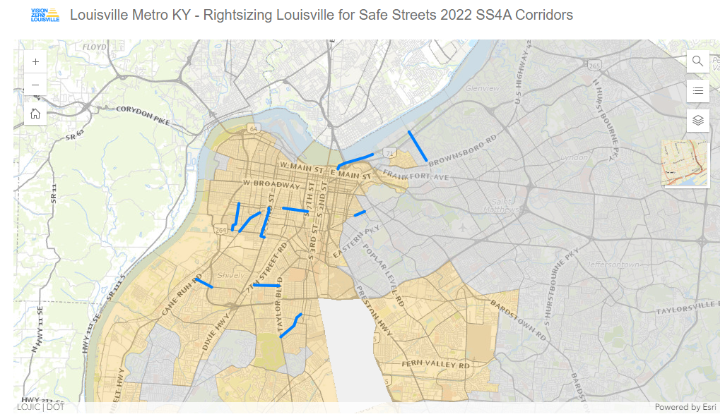 Map of ten SS4A corridors (blue) and USDOT-defined Justice40 areas (orange).
|
Corridor
|
From
|
To
|
| Wilson Ave |
S. 26th St |
Algonquin Pkwy |
| W. Oak St |
S. 7th St |
S. 16th St |
| E. Oak St |
Mary St |
Barret Ave |
| Berry Blvd (US 60A) |
Manslick Rd/7th Street Rd |
Taylor Blvd |
| Crums Ln (KY 2049) |
Cane Run Rd |
Cheviot Dr |
| River Rd |
Witherspoon St |
Beargrass Creek |
| Zorn Ave |
Madelle Ave |
River Rd |
| S. 22nd St (US 31W) |
Bernheim Ln |
Dumesnil St |
| Southern Pkwy |
Woodlawn Ave |
Taylor Blvd |
| Louis Coleman Jr. Dr |
Virginia Ave |
Algonquin Pkwy |
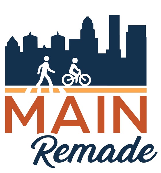 The Kentucky Transportation Cabinet (KYTC) will hold a public meeting to update residents on planned improvements for phase one of the Main Remade project in Jefferson County. The project is designed to improve safety and accessibility along one of downtown Louisville’s key business, residential, and tourism corridors – Main Street.
Phase one of the project will convert Main Street from the current one-way street into a two-way street between Wenzel Street and 2nd Street. In addition to the one-way to two-way configuration, other improvements to the corridor include upgrades to crosswalks and intersections, a protected bike lane, dedicated left-turn lanes, and new traffic signals. Improvements will occur in three phases with construction on phase one expected to begin as soon as late 2024. Throughout construction, Main Street will remain open to traffic.
The public meeting will be conducted in an open house format on Tuesday, March 19, from 5:30 to 7:30 p.m. at Louisville Slugger Field, 401 East Main Street. During the public meeting, attendees may view project maps and review information about planned improvements along the Main Remade project area. Representatives from KYTC and the design consultant will be in attendance to answer questions from residents and roadway users. Attendees will have an opportunity to make public comments and provide feedback directly to the project team.
Those unable to attend may review information online after Tuesday, March 19, at MainRemade.com. Comments may be emailed to info@mainremade.com before Tuesday, April 16. Following the public meeting, displays and materials will be available for review at the KYTC District 5 Office in Louisville. Office hours are Monday through Friday from 8 a.m. to 4:30 p.m., with written comments accepted through Tuesday, April 16. Comments may also be submitted by mail before Tuesday, April 16, to the KYTC District 5 Office, 8310 Westport Road.
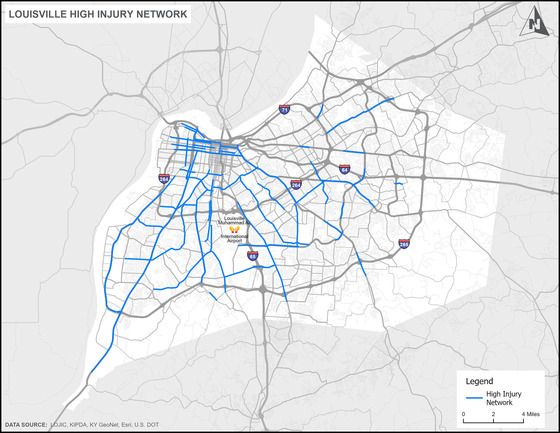 Louisville's first-ever High Injury Network received some press recently after it was released in January.
Louisville Public Media: "Louisville's High Injury Network could help prioritize improving safety on certain roads," March 5, 2024.
WHAS11: "'The roads down here suck!: Louisville metro outlines the city's most dangerous roads," March 5, 2024.
WDRB: "New study ranks the 53 most dangerous stretches of roadway in Louisville," March 6, 2024.
A High Injury Network is a data-driven approach which identifies non-interstate roadway segments that account for a disproportionate amount of a community's fatal and serious injury crashes. The High Injury Network allows communities to focus limited resources on improving safety along those high priority, dangerous corridors. The routes identified in Louisville's High Injury Network will guide the city's Safer Roads strategy, in support of Louisville's vision to eliminate roadway deaths on surface streets by 2050.
The 2024 Safety Summit will be the first time that all transportation safety topics for travelers and workers alike will be combined into a single state conference. It will bring together a combination of engineering, education, emergency services, enforcement, and transportation safety warriors to share best practices, research, and proven innovations. The Summit will provide information on both successful programs and emerging issues to individuals who work to prevent fatalities and injuries on Kentucky's roadways, increase safety awareness, prevent injuries and incidents with employees, and provide opportunities for networking, discussion, and information sharing.
The Vision Zero Louisville Task Force is a collaborative effort among representatives from multiple government departments, transportation agencies, advocacy groups, healthcare organizations, universities, and law enforcement agencies. The Vision Zero Louisville Task Force meets monthly and is open to the public.
Join us for the February meeting when we will discuss the development of Louisville's first ever Speed Management Plan.
Safer Speeds is one of the five Safe System Approach overlapping strategies to prevent fatal and serious injury crashes. The Speed Management Plan will serve as Vision Zero Louisville's plan for our Safer Speeds strategy. The plan will recommend national best practices on speed limit setting and evaluation, identify roadway segments with large discrepancies between posted and actual speeds, and recommend programs and tools to encourage travel speeds closer to the posted speed limit. The plan, led by WSP and made possible by support from KYTC, is expected to be completed by the end of the year.
|