Indiana Geographic Information Office - NEWS

Geographic Information Office NEWS

Office of the GIO

GIS Logo
NSGIC

NSGIC Announces New Board Members; Indiana’s GIO, Megan Compton Elected to the Board of Directors

National States Geographic Information Council (NSGIC) announces the appointment of five new members to its Board of Directors, as well as the full slate of officers and board members for the 2020 - 2021 term. Megan Compton (IN), Indiana’s Geographic Information Officer, has been elected as Director. Press Release 


Vaccine

How to get the first COVID-19 vaccines to people who need it most

Whenever a vaccine is ready, mapping software will be crucial to helping states distribute it. Not everyone will be able to get the COVID-19 vaccine when it's ready. So even as companies like Pfizer and Moderna race to complete their clinical trials, governments are beginning to strategize how to distribute that very limited supply once it's ready. Este Geraghty, chief medical officer of the mapping software giant Esri, thinks her company's technology can help. Article


Free coronavirus map from Esri tracks in the U.S.

The program is intended to give users context at a glance. Esri’s new CovidPulse map is an electrocardiogram for every county and state in the country. Is an area recovering or on life support? Is coronavirus spreading or controlled? Article


Data Sharing DashBoard
Data Harvest

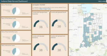
2020 Indiana Data Harvest Program

2020 Data Harvest Program is on track, thanks to the support of our counties and partners. Due to this collaboration, Indiana has a new, complete statewide parcel dataset. The Geographic Information Office collaborates across the state to obtain the following datasets (addresses, parcels, road centerlines and government boundaries). For more information and to track county participation, visit the Dashboard.


Big Ten Conference

BIG TEN - Academic Alliance GIS Conference - November 13, 2020

The BTAA GIS Conference is intended to promote conversation and collaboration between Big Ten researchers, educators, and students who use geospatial information. It is open to all who wish to attend, including GIS professionals and students who are out of Big Ten academic alliance.
Registration

Having trouble viewing this email? View it as a Web page.


NOVEMBER 2020

Megan Compton

Megan R.L. Compton
Indiana Geographic Information Officer (GIO)

IN Office of Technology
100 North Senate Ave.
Government Center North
Indianapolis, IN 46204

Office: (317) 234-5889
gio@iot.in.gov


GIS Day 2020

International GIS Day
November 18, 2020

Participate in the international celebration of GIS technology. GIS is a scientific framework for gathering, analyzing, and visualizing geographic data to help us make better decisions. Registration


IU Bloomington GIS Day - November 13, 2020

GEOGRAPHIES OF DISRUPTION: Mapping to make sense of 2020’s sociopolitical upheaval. Experts will explore the disenfranchisement and disruptions of 2020, and examine how mapping can help us make sense of crucial issues both during this historic year and beyond. Details


GIS Day at Notre Dame  - November 18, 2020

Join them as they celebrate GIS Day — an annual salute to geospatial technology and its power to transform and better our lives and the lives of those around us. GIS Day at Notre Dame will include two virtual workshops presented by GIS librarian, Matthew Sisk. Register


GIS Day