|
Youngs Creek Park
By Chip Orner, CPRE, City of Franklin
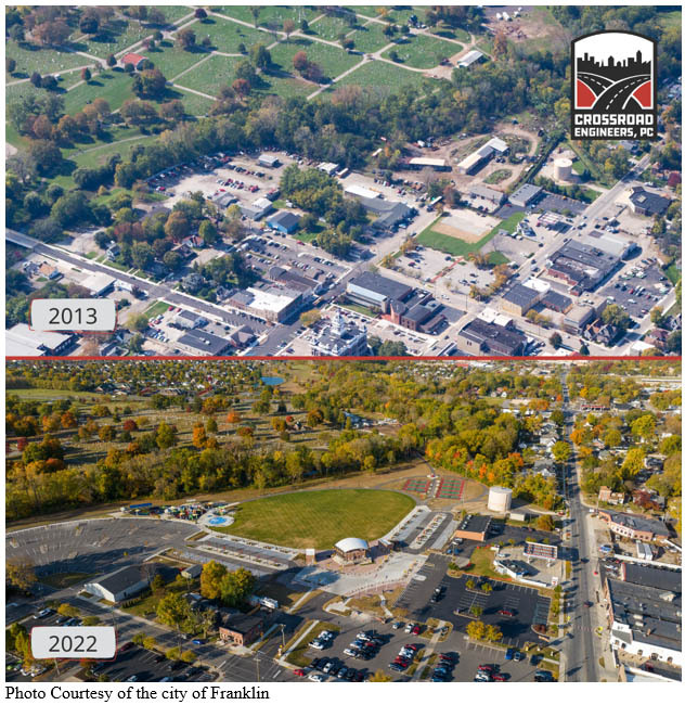
June 10, 2008, in Franklin started out as a cloudy, rainy day, but by mid-day, the city was experiencing a 1,000-year flood. With more than 11 inches of rain in a short period, the city experienced rapid flash flooding that changed its landscape forever. Entire neighborhoods were underwater. Several downtown businesses and government buildings were underwater. U.S. 31, the local cemetery, the recreation center and several parks were underwater. Police vehicles and an entire skate park washed away. Devastation from flash flooding covered a large section of Franklin’s downtown core. This article will focus on one area of the city that experienced massive flooding and how through years of careful planning and execution, this area was reborn into a downtown community gem.
The southwest quadrant of downtown Franklin was home to a wrecker service and body shop, water solutions business, county government buildings, plumbing service, and previous junk yard. This area, located within the flood plain, was heavily flooded in 2008, negatively impacting these businesses. The county courthouse annex building had to be demolished. Then in 2017, the businesses that remained were again flooded with a 6-inch rainfall. After much thought and planning, the city worked with these businesses to purchase their properties and assist in relocation to higher ground. Several buildings and fences were taken down to remove them from the floodplain.
After the 2008 flooding, brainstorming, and planning began to find solutions to the downtown flooding situation. What could be done to prevent further losses? What could this southwest quadrant of the city look like and what would be sustainable after Youngs Creek had flooded so much? The city focused on three goals in the redevelopment of this area of the city: (1) Use this area to help retain flood water by providing more absorption area, which can help alleviate flooding in the downtown area, (2) Use this area to expand economic development opportunities in the downtown area, and (3) Use this area to elevate Franklin’s quality of life. The result of the 10-year planning process is what is known today as Youngs Creek Park. The new $9 million park was funded with a Redevelopment Commission bond from designated Tax-Increment Financing (TIF) districts in Franklin and several community sponsorships, partnerships, and grants. These include the DriveHubler.com Amphitheater, the Indiana-American Water Spray Park and the Mutual Savings Bank park shelters.
Now, Youngs Creek Park is a 14-acre green space in the heart of downtown Franklin, its newest community event space. It includes an amphitheater with a 5,000-person lawn seating capacity as well as public restrooms, a splash park, large playground, eight pickleball courts, four park shelters, walking trail connections to the Franklin Greenway Trail system and vendor space for more than 100 farmers market vendors. Youngs Creek Park has become a focal point for the community hosting several free events and adding to the quality of life. It also serves as ample space for flood water absorption and greenspace. Youngs Creek Park has been designed and built to withstand flooding.
Youngs Creek Park is the result of turning the tragic 2008 flooding event into a positive outcome for the city of Franklin. Through the diligent planning process conducted by the city’s team, this area has proven to meet the three original goals for the area: flood water absorption to alleviate downtown flooding, capitalize on economic development opportunities downtown and create a world class park for our residents. The new park and amphitheater opened in May 2022.
Technical Bulletin 10
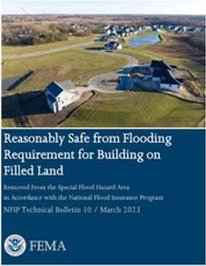
In March, FEMA announced the release of the National Flood Insurance Program (NFIP) Technical Bulletin 10, Reasonably Safe from Flooding Requirement for Building on Filled Land Removed From the Special Flood Hazard Area in Accordance with the National Flood Insurance Program (TB 10). This publication is the latest update to the NFIP Technical Bulletin series.
TB 10 provides guidance on the NFIP requirements that determine if buildings constructed on filled land will be reasonably safe from flooding. Guidance is provided for the placement of fill and the parameters for the design as well as construction of buildings on filled land that has been removed from the Special Flood Hazard Area through the flood map revision process managed by FEMA.
The major updates in TB 10 include:
- The title has been updated. It was previously Ensuring That Structures Built on Fill In or Near Special Flood Hazard Areas Are Reasonably Safe From Flooding in Accordance with the National Flood Insurance Program.
- The intent of TB 10, and when it is appropriate to use TB 10, has been clarified.
- Increased emphasis on documentation needed for a local official to make the “reasonably safe from flooding” determination.
- Additional best practices are provided.
- Grouped and reorganization of the content discussing the Technical Approaches to Seepage Analysis in Section 9.
To learn more about the eleven NFIP Technical Bulletins, visit the FEMA National Flood Insurance Technical Bulletins.
|
2023 Legislative Session and Floodplain Management
By Jennifer Ware, Division of Water
The 2023 legislative session has ended and there was a lot of discussion at the statehouse regarding floodplain management. The Division of Water is working hard to digest the changes and hopes to have more information, guidance, and documents coming out to soon. For now, here is a high-level recap of the session:
- Using the best available floodplain layer on the Indiana Floodplain Information Portal (INFIP) is still required when reviewing a permit application. After June 30, a person who applies for a local floodplain permit may elect to use the best available floodplain layer provided by the department on INFIP or an engineering study provided by the applicant that has been reviewed and approved by the department. This option has always been available, now it is stated in statute.
- Any person, including a local official, has the option to request the department to review the best available floodplain layer at a site. The review will be provided at no cost to the requestor and the department should communicate the results within 120 days of the request.
- After June 30, 2025, a person may not serve as the local floodplain administrator unless they have successfully completed the Certified Floodplain Manager (CFM) program or another training program approved by the department. Expect more information soon from the department regarding trainings that will be offered to meet this requirement.
- Another option that has always been available is for a local official to request a meeting with the department to discuss identification and delineation of flood hazard areas within the community in addition to necessary ordinances and other rules. Starting July 1, the department will hold a meeting at least once every five years with communities to promote cooperation in participating in the National Flood Insurance Program, provide technical assistance and data, conduct trainings, and provide communication and outreach.
Division of Water Staff Changes
The Division of Water has gone through several staff changes this year.
In March, Christie Stanifer rejoined the Division of Water as the section manager of the Compliance and Enforcement section. Christie has been with DNR for over 22 years and was most recently with the Division of Fish & Wildlife as the environmental coordinator over the DNR’s early coordination process. Christie started her career with DNR working for the Division of Water in the Technical Services section.
In March, Lydia Dutton joined the Floodplain Management section. Lydia has been assigned responsibility for the NFIP communities in the northern region of the state. She has a Master of Science in Watershed Resource Management degree from Michigan State University. She graduated summa cum laude after completing studies in applied mapping and geology, the use of geographic information systems, and laws and regulations for water resources. She also earned an undergraduate degree in legal science from Everest College in 2014 and a professional degree in landscape architecture from Michigan State University in 2005.
In May, Savannah Riley joined the Floodplain Management section. Savannah has been assigned responsibility for the NFIP communities in the southern region of the state. She has a Bachelor of Science in Biology from Manchester University. Savannah has been with DNR for more than seven years and was recently with the Division of State Parks. Savannah started her career with DNR working for the Division of Fish & Wildlife as the assistant coordinator for the Go FishIN Program.
Our Technical Services section added two new staff. Sarah Black, who transferred from the Division’s Floodplain Management section, and Christina Spielbauer, who came from the private sector. The section in still looking to fill two other vacancies.
Our Engineering section also added a new staff member, Anastasia Theresa Ingermann (Theresa). Theresa graduated from Purdue University with a Bachelor of Science in Agricultural Engineering with a major in Environmental and Natural Resources Engineering. She has an EIT and has a certificate for small, unmanned aircraft systems remote pilot. Theresa has a publication in the Journal of Environmental Engineering. She was previously working at Thomas & Hutton in Savannah, Georgia. She moved from Georgia to her home in Indiana in May 2023 and joined the ESC team on May 15 as a hydraulic engineer.
Also in Engineering, Adam Bales was promoted to hydraulic engineer supervisor.
Upcoming Training Opportunities

(Information from FEMA, ASFPM, and other websites)
Association of State Floodplain Managers (ASFPM)
ASFPM has an online training program, and new training is added regularly. See floods.org/training-knowledge-center for more information.
FEMA’s Emergency Management Institute (EMI)
In-person classes have resumed at EMI in Emmitsburg, MD and still offers many courses through self-study webinars. Currently, E0273: Managing Floodplain Development through the NFIP, is scheduled for August and October 2023 and February, March, April, and September 2024. For additional information on EMI classes and webinars, please visit EMI’s training calendar website at training.fema.gov/emicourses/schedules.aspx and its course catalog at firstrespondertraining.gov/frt/npccatalog/EMI.
FEMA Region 5 announces continued training opportunities
FEMA Region 5 is conducting regular webinars on various topics such as floodplain management, flood insurance, and National Flood Insurance Program (NFIP) requirements to educate and train community officials on managing their community’s floodplains. Each webinar lasts an hour, and one ASFPM CFM CEC is available by attending a session. The virtual webinar is open to all; however, local and county officials working in emergency management, building code administration, and floodplain management are strongly encouraged to attend. The webinar is presented by FEMA Region 5’s Mitigation Division, Floodplain Management and Insurance Branch.
For more information on the series or to register, see dnr.IN.gov/water/events-and-training.
STATE TRAINING OPPORTUNITIES
Indiana Department of Natural Resources
A Substantial Improvement and Substantial Damage Workshop will be held on Wednesday, June 21 from 9–11 a.m. ET. For more information on the session or to register, see dnr.IN.gov/water/events-and-training.
For other upcoming events and training hosted by the DNR Division of Water, check dnr.IN.gov/water/events-and-training. We will post training videos and other opportunities as they are developed or scheduled.
Indiana Department of Homeland Security
Please visit the Indiana Department of Homeland Security’s training calendar for upcoming courses and trainings at oas.dhs.IN.gov/hs/training/public/calendar.do.
Certification
The Certified Floodplain Manager (CFM) exam is now digital and may be taken at your convenience at a Meazure Learning (formerly Scantron) test site or from your home or office. For information on the exam or to register visit ASFPM’s website, floods.org/certification-program-cfm.
|
ASCE/SEI 7- 22, Chapter 5
The American Society of Civil Engineers has recently released updates and a supplement to the 7-22 publication primarily focused on flood loads. To read more about the updates and supplement refer to the society’s website.
THANK YOU
Thanks to those contributing to this issue: Dave Knipe, Jennifer Ware, Anita Nance, Darren Pearson, Lydia Dutton, Savannah Riley, Alysson Oliger, Moumita Mukherjee, Marty Benson, Scott Roberts, Don Kaczorowski, and Ed Reynolds.
Editor – Doug Wagner
The work that provides the basis for this newsletter was supported by funding under a cooperative agreement with the Federal Emergency Management Agency. The author and publisher are solely responsible for the accuracy of the statements and interpretations contained in the publication. Such interpretations do not necessarily reflect the views of the federal government.
Waterlines is produced quarterly as a public service by the DNR Division of Water.
Waterlines is available on the Web at dnr.IN.gov/water/publications/waterlines-newsletter/.
Having trouble viewing this email? View it as a Web page.
|