A City’s Steadfast Resolve for Flood Resiliency
By Rod Renkenberger, Director, Maumee River Basin Commission (MRBC) & Doug Wagner, Division of Water
Beginning in 1997, after learning about FEMA’s then-new Flood Mitigation Assistance (FMA) grant program, the City of Decatur has now closed on more than 100 structures to become a flood-resilient community.
After leaning about the FMA grant program, Director Rod Renkenberger of the Maumee River Basin Commission (MRBC) approached then State Hazard Mitigation Officer (SHMO) Philip Rader about applying for the funds as a “proactive” mitigation approach. After securing his support, Renkenberger then reached out to sitting Mayor Fred R. Isch, City of Decatur. Isch also provided his support, and Renkenberger submitted the city’s first grant application in 1997, which was approved in 1998. By 2001, MRBC and Decatur had acquired 10 homes and removed them from the Special Flood Hazard Area (SFHA) using a combination of FMA and Hazard Mitigation Grant Program (HMGP) grant funds.
In July of 2003, record flooding in the area accelerated the city’s mitigation strategy due to the number of homes substantially damaged. In 2004, Decatur partnered with MRBC and submitted an HMGP grant application for 53 of the most vulnerable damaged homes. The grant was approved in mid-2004. Unfortunately, that approval only included 16 of those homes. The city followed up with another grant application in 2005 for the remaining 37 homes, receiving approval in March of 2006. By mid-2007, Decatur had acquired and demolished all 37, bringing the total number of homes removed from the SFHA to 63.
After a seven-year lull in flooding, Decatur experienced another major flood in June 2015. The city again partnered with MRBC and submitted an HMGP application for another five homes after securing support of the Decatur City Council. Decatur and MRBC have continued to mitigate flood damages since. In 2016, MRBC prepared the city’s first Pre-Disaster Mitigation (PDM) grant application for six structures, again supported by the city council.
In 2017, interest peaked for participating in MRBC’s Voluntary Buyout Program. MRBC worked with the mayor and city council preparing three PDM applications. The first for 10 structures, the second for eight structures, and the third for a single “critical facility”, Evergreen Assisted Living. This joint effort continued through 2018 with application for nine structures and 2019 for an additional four structures.
To date, 100 structures have been acquired. With three open PDM grants remaining, the potential exists to include up to five more homes. In addition to the buyouts, Decatur also partnered with MRBC to dry floodproof six nonresidential structures as a mitigation alternative.
Having taken exhaustive measures to contact the few remaining property owners with structures located in the SFHA where those property owners are choosing not to participate in the program, Decatur officials and MRBC now consider the City a “Flood Resilient Community”.
These activities have spanned four mayors and SHMOs, three city attorneys, two floodplain administrators, and other key players to ensure the program’s success.
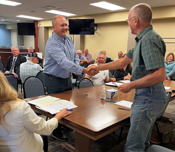 Mayor Dan Rickord presents a check to Paul Mowery in exchange for keys as part of the 100th structure buyout in the City of Decatur. (Photo courtesy of Rod Renkenberger)
Proposed Elevation Certificate
By Doug Wagner, Division of Water
There is a new Elevation Certificate (EC) form proposed and under review at the Office of Management and Budget (OMB). Professionals should continue to use the current form, although expired, until FEMA announces OMB approval and issues a memorandum highlighting the changes.
The proposed EC has substantial changes and modifications. Two new sections have been added. The instructions are now clearer, which should simplify completion. The proposed EC allows for more detail about venting (flood opening) requirements. It also asks for first floor height, which is different from the lowest floor elevation. Section G is now a section and not optional, as in previous versions. Section H, a new section, was added specifically for insurance purposes. Remember, with Risk Rating 2.0, an EC is no longer required for flood insurance purposes. Individuals will receive the most beneficial rate, the one from the rating engine or the one using information provided on an EC, for the structure to be insured. Nevertheless, the requirement for having an EC to demonstrate compliance at the local level has not changed for new and substantially improved structures.
Another proposed change is the requirement for photos. It is being updated to require a minimum of four photos, one showing each side of the structure. This replaces the two required for insurance purposes in previous versions, with the only exception being row homes or townhouses that may have a common wall with the structures next to them.
In this article we have shared some of the proposed changes to the EC. We will share further information when the new EC is released with a more exhaustive review.
2022 INAFSM Conference
By Doug Wagner, Division of Water
The Indiana Association for Floodplain and Stormwater Management (INAFSM) hosted its 26th Annual Conference, Sept. 14-16. This year’s conference was held at the Century Center in South Bend.
The conference had an excellent offering of educational classes and sessions. There were also a record number of attendees at this year’s conference.
INAFSM again presented awards to recognize member achievement at the reception dinner on Wednesday evening.
Lifetime Membership awards were presented to Ken Hedge and Susan Bodkin in recognition of their longtime contribution and services to the association.
The Excellence in Stormwater Management was presented to Alicia Barnard with the City of Terre Haute.
The Outstanding Stormwater Project was the Old City Park and Surina Way Improvements. Project Owner was the City of Greenwood and project engineer was Rundell Ernstberger Associates.
The Excellence in Floodplain Management award went to Chelsea Cottingham, City of Columbus & Bartholomew County. Chelsea’s efforts with local realtor and citizen education have implemented new requirements that determine if structures are compliant upon property transfer. She also played a significant part in the development of the communities’ flood risk management plan, is active during the, and coordinates the Community Rating System (CRS) Program for both communities.
The Outstanding Floodplain Project award went to the Tippecanoe County Flood Inundation Library. The project owner was Tippecanoe County Emergency Management Agency & Tippecanoe County. The project consultant was Christopher B. Burke Engineering, LLC.
The Excellent Strides in Floodplain Management award was presented to Tammy Behrman, AICP with the Monroe County Plan Commission. Tammy’s efforts with adoption of updated ordinances, pursuing violations, and improvements to the community’s floodplain management program were cited in her nomination.
The Outstanding Education/Outreach Award was presented to Stormwater Landscape Training Program. This program is operated by the White River Alliance Regional Stormwater MS4 Education Team.
The final award was the Chairman’s Award for Outstanding Service in Support of the INAFSM. This year the award was given to Amy Harvel and Sheila McKinley.
|
 Lowest Floor
By Darren Pearson, Division of Water
Floodplain administrators who review building plans and elevation certificates as required for communities that participate in the National Flood Insurance Program (NFIP) must understand what is meant by “lowest floor”. Lowest floor is defined in the Floodplain Management Rules (312 IAC 10-2-28) and in the Indiana model floodplain ordinance as:
Lowest floor means, for floodplain management purposes, the lowest elevation described among the following:
(1) The lowest floor of a building.
(2) The basement floor.
(3) The garage floor if the garage is connected to the building.
(4) The first floor of a structure elevated on pilings or pillars.
(5) The floor level of any enclosure, other than a basement, below an elevated structure where the walls of the enclosure provide any resistance to the flow of floodwaters. Designs for meeting the flood opening requirement must either be certified by a registered professional engineer or architect or meet or exceed the following criteria:
a. The walls are designed to automatically equalize the hydrostatic flood forces on the walls by allowing for the entry and exit of floodwaters.
b. At least two (2) openings are designed and maintained for the entry and exit of floodwater; and these openings provide a total net area of at least one (1) square inch for every one (1) square foot of enclosed area. The bottom of all such openings shall be no higher than one (1) foot above the exterior grade or the interior grade immediately beneath each opening, whichever is higher. Doorways and windows do not qualify as openings.
(6) The first floor of a building elevated on pilings or columns in a coastal high hazard area (as that term is defined in 44 CFR 59.1), as long as it meets the requirements of 44 CFR 60.3.
Using LiDAR for Map Amendments
By Doug Wagner, Division of Water
Many communities across the state use “light detection and ranging” (LiDAR), or it is available to them as part of the community’s “Geographic Information System” (GIS) platform. With updates in technology, many communities use GIS to identify problems, monitor change, manage and respond to natural disasters, map properties, and even to permit local development.
For communities that participate in the National Flood Insurance Program (NFIP), GIS can be a helpful tool for mapping applications. They can add their Flood Insurance Rate Maps (FIRMs) layer and Best Available Flood Layer (BAFL) as well as any Letters of Map Amendment (LOMAs) to the tool. This allows a community to easily review the maps or amendments when reviewing permit applications.
With updates in the quality of data received statewide, communities may now be eligible for using this LiDAR data to apply for a LOMA. Using LiDAR data can replace the requirement to submit elevation information by a licensed surveyor or engineer, which may create a cost savings for property owners; however, LiDAR data may be less accurate than certified elevations and may not capture the full risk for the building or lot in question.
You can obtain LiDAR data for your community here: LiDAR Data hosted by iDiF @ Purdue. The base flood elevation (BFE) for the site can be found here: www.infip.dnr.in.gov.
For more information on using LiDAR for map amendments refer to the FEMA fact sheet.
Division of Water Staff Changes
By Doug Wagner, Division of Water
Some recent staff changes have taken place in the Division of Water (DOW).
In May, Jennifer Ware and Moumita Mukherjee were promoted to assistant directors, filling vacancies created by the retirements of Jim Hebenstreit and George Bowman.
Moumita has been with the division since 2019 and was the manager for the Dam & Levee Safety Section. During her time here, she’s launched a new and improved Dam Safety web page and web application for inundation mapping. Moumita also led the implementation of the Low Head Dam Safety program. Immediately before joining DNR, she was on the faculty at the University of Evansville. She holds a Ph.D. from Michigan State University and is a Registered Professional Engineer.
Jennifer has been with the division since 2007 and was the manager for the Technical Services Section. She’s led numerous initiatives to improve the various regulatory programs of the division. She holds a B.S. from Ball State in Geography with a concentration in Meteorology.
Garth Lindner was promoted to manager of the Resource Assessment Section. Garth has been with the division since 2020 as Hydraulic Engineer and was the acting manager for the Dam & Levee Safety Section. He holds a Ph.D. from University of Maryland, Baltimore County. Both his M.S. and B.A. are from Indiana University. Immediately before joining DNR, he was a postdoctoral research fellow at University of Missouri. During his time in the Dam & Levee Safety Section, he helped launch the web application for inundation mapping for dam risk awareness and has presented about this mapping project at conferences and annual meetings held by IWRA, Indiana Geologists, and the DOW. Garth brings a depth and breadth of expertise and experience to enhance the DOW’s role in serving Indiana’s water planning needs. Garth began his duties in this new position on Nov. 14.
Alysson Oliger was promoted to serve as the new manager of the Technical Services Section. Alysson received her B.S. in Public Affairs from Indiana University Purdue University Indianapolis (IUPUI) in 2007. After graduation, Alysson began her career with the DOW as an Environmental Manager in the Technical Services Section. She then moved in 2017 to the division’s Compliance Section. Alysson has participated and led several teams and projects that have achieved huge accomplishments for the division. Most recently, she contributed to the development of INFIP 2.0 and a Silver Jackets partnership to create a wetland story map, which promotes education to the public. She brings an overall knowledge of the division and its regulations, along with 15 years of experience to this new role, which she started Nov. 28.
Upcoming Training Opportunities

(Information from FEMA, ASFPM, and other websites)
Association of State Floodplain Managers (ASFPM)
ASFPM has an online training program, and new training is added regularly. See floods.org/training-knowledge-center/ for more information.
FEMA’s Emergency Management Institute (EMI)
In-person classes are resuming at EMI after most had been canceled or held virtually last year. EMI still offers many courses through webinar training opportunities. Currently, E0273: Managing Floodplain Development through the NFIP, is scheduled for February, May, and August of 2023. For additional information on EMI classes and webinars, please visit EMI’s training calendar website at training.fema.gov/emicourses/schedules.aspx and its course catalog at firstrespondertraining.gov/frt/npccatalog/EMI.
FEMA Region 5 announces new and continued training opportunities
FEMA Region 5's Flood Insurance Liaison will host a series of webinars about flood insurance through the NFIP and the NFIP's new pricing methodology known as “Risk Rating 2.0: Equity in Action”. In most cases, there is a 30-day waiting period before flood insurance policies become effective. Start your preparations early by learning more about flood insurance today.
FEMA Region 5 is conducting regular webinars on various topics such as floodplain management, flood insurance, and National Flood Insurance Program (NFIP) requirements to educate and train community officials on managing their community’s floodplains. Each webinar lasts an hour, and one ASFPM CFM CEC is available by attending a session. The virtual webinar is open to all; however, local and county officials working in emergency management, building code administration, and floodplain management are strongly encouraged to attend. The webinar is presented by FEMA Region 5’s Mitigation Division, Floodplain Management and Insurance Branch.
For more information on either series or to register, visit our events and training page at dnr.IN.gov/water/events-and-training.
STATE TRAINING OPPORTUNITIES
Other Upcoming Events and Training
For other upcoming events and training hosted by the DNR Division of Water, check dnr.IN.gov/water/events-and-training. We will be posting training videos and other opportunities as they are developed or scheduled.
Indiana Department of Homeland Security
Please visit the Indiana Department of Homeland Security’s training calendar for upcoming courses and trainings at oas.dhs.IN.gov/hs/training/public/calendar.do.
Certification
The Certified Floodplain Manager (CFM) exam is now digital and may be taken at your convenience at a Meazure Learning (formerly Scantron) test site, from your home, or your office. For information on the exam or to register visit ASFPM’s website: https://www.floods.org/certification-program-cfm/
|
THANK YOU
Thanks to those contributing to this issue: Dave Knipe, Jennifer Ware, Anita Nance, Darren Pearson, Moumita Mukherjee, Garth Lindner, Alysson Oliger, Rodney Renkenberger, Marty Benson, Don Kaczorowski, and Ed Reynolds.
Editor – Doug Wagner
The work that provides the basis for this newsletter was supported by funding under a cooperative agreement with the Federal Emergency Management Agency. The author and publisher are solely responsible for the accuracy of the statements and interpretations contained in the publication. Such interpretations do not necessarily reflect the views of the federal government.
Waterlines is produced quarterly as a public service by the DNR Division of Water.
Waterlines is available on the web at dnr.IN.gov/water/publications/waterlines-newsletter/.
Having trouble viewing this email? View it as a Web page.
|