|
The Flood Control Act & Best Available Data
By Doug Wagner, Division of Water
The Flood Control Act was amended during the last legislative session to include a section on the use of the best floodplain mapping data available. The section reads, “A local floodplain administrator shall utilize the best floodplain mapping data available as provided by the department and located on the Indiana Floodplain Information Portal when reviewing a permit application for a structure or a construction activity in, or near, a floodplain.” (IC 14-28-1-40) This amendment went into effect on July 1.
Communities must refer to the “best available” data layer when permitting development in or near “A” zone flood hazard areas designated on the community’s Flood Insurance Rate Map (FIRM) that is currently effective. “A” zones are areas where only an approximate study was completed prior to the effective FIRM. With the further studies now completed by the DNR Division of Water, more detailed information is available in the “best available” layer and must be used in accordance with the general provisions article of the local floodplain ordinance.
The basis for establishing the regulatory flood data section of the general provisions section is to provide the zones and flood insurance study information for the community. This section of the ordinance also states that in “A” zones, in the absence of published maps, or absence of identification on the maps, the best data available, as provided by the DNR, is to be used, provided the upstream drainage area of the subject site is greater than one square mile.
A community can look at this layer on the Indiana Floodplain Information Portal (INFIP) https://infip.dnr.in.gov/ and determine if a floodway permit is required. The community also has the responsibility of requiring that the base flood elevation (BFE) be provided by the DNR in accordance with 312 IAC 10-3-3. Anyone can now visit INFIP to obtain a BFE for most streams with an upstream drainage area greater than one square mile.
When looking at the “best available” data layer, local administrators will see drastic changes in some areas and minor differences in others. The most significant noted change for any area is the delineation of the floodway in the “A” zones. Some communities will see areas designated that were not previously mapped or identified on the FIRM. This situation makes it extremely important that local administrators review their flood hazard areas to ensure compliance with their local ordinance.
The Indiana DNR Division of Water has undertaken a project to create and update traditional Flood Insurance Rate Maps, which are published by FEMA, to include many more stream reaches than are currently officially published in the National Flood Hazard Layer. Local officials can request to receive notification when updates are made, download the “best available” data layer by county, or sign up for ArcGIS REST services at: https://www.in.gov/dnr/water/surface-water/indiana-floodplain-mapping/the-indiana-best-available-floodplain-mapping/.
The more-accurate limits of the floodplain will at some point be included on the FIRMs. Requiring any development to comply with the NFIP and community regulations at the time of permitting will save a great deal of time and expense in the future.
Septic Systems in the Floodplain
By Alyssa Damiano, Division of Water
Homeowners who live beyond the reaches of a municipal sanitary sewer are required to locate a safe site for their septic system, one that is protected from floodwater infiltration. Identifying the appropriate location should be the first step in designing an approved septic system for the property. Keep in mind, DNR does not administer any part of “On-site Sewage Systems”. Those rules are enforced and permitted only by the Indiana Department of Health and local county health departments.
In order to make the appropriate determination for the location of a septic system, local health departments and homeowners should use the DNR’s Indiana Floodplain Information Portal (INFIP). This is a useful tool to help property owners and local health departments select an appropriate location for the septic system. An onsite soil evaluation is required prior to any septic system installation, and officials can ensure they are evaluating proper locations by using the DNR’s floodplain tool. A professional land surveyor should also be hired to determine the location of the base flood elevation at the site. The bottom of the trenches in a subsurface trench system must be above the base flood elevation (BFE) in order to have an approvable system. In the floodplain, tank lids must also be above the BFE to prevent the infiltration of floodwaters. Similarly, replacement systems are held to these same standards. When replacing a failed septic system, the local health department may use best judgment to allow the septic system in the floodplain if there are no other options for a replacement system. Only in rare circumstances are septic systems permitted to be located in an identified floodplain.
A common misconception is that fill can be placed in the floodplain to allow for septic system placement; however, disturbed soil cannot be used for the soil absorption system due to the variability of the fill soil, disturbed soil structure, and the potential for containing debris. As a result, some properties located in an identified floodplain may not have a suitable location for an approved septic system.
An elevated sand mound may be an alternative option to a subsurface system in a mapped floodplain, provided verified natural grade elevations are determined to be at/above the BFE at the site. Elevated sand mound systems are built from the ground up, and the absorptive surface is where the soil and sand meet, which is at original grade. The absorptive area must be above the BFE (so for an elevated system, original grade must be at/above the BFE). These systems require specific tilling practices and Indiana Department of Transportation Spec 23 sand to have an approvable system. In such a case, a Letter of Map Amendment removing the area of land with natural grade elevations at/above the BFE is recommended.
Systems can be located anywhere on the property where soils and site conditions are suitable if that area is not in the floodplain and meets the proper elevation requirements. If there is not an acceptable location on the property for a septic system, an easement to a suitable location on nearby property may be used. When this is not an option, extending municipal sewer lines or using a forced main sewer is acceptable. More information on specific septic system requirements is at Residential On-site Sewage Systems, Rule 410 IAC 6-8.3.
Coastal Hazards & Resiliency
By Joe Exl, Division of Nature Preserves
The Indiana Department of Natural Resources (DNR) Lake Michigan Coastal Program (LMCP) provides guidance, technical support, and financial assistance to municipal, county, and state government agencies within northwest Indiana’s coastal region. Earlier this year, the LMCP started a programmatic enhancement project that will result in the development of technical resources for the State of Indiana and Lake Michigan coastal communities to prevent or reduce coastal natural hazard risks. Natural hazards being addressed through the project include coastal and riverine flooding, coastal and fluvial erosion, Lake Michigan water level changes, and coastal storms.
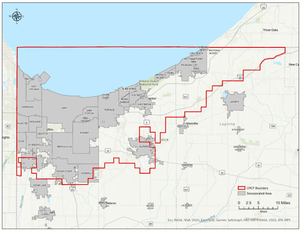 For the first phase of the five-year project, the LMCP is partnering with the Northwestern Indiana Regional Planning Commission (NIRPC) to develop and administer a local government self-assessment tool and follow-up listening sessions. The self-assessment tool should help local government staff and decisionmakers evaluate the potential impacts of natural hazards and consider planning and mitigation actions that may increase resilience to such events. For example, with most of our coastal communities already participating in the National Flood Insurance Program, the LMCP wanted to determine what requirements communities may be meeting with the Community Ratings System (CRS) program without participating. DNR Division of Water floodplain management staff have been instrumental in identifying assessment questions.
The baseline information gathered from the needs assessment and listening sessions will help the LMCP identify, develop, and deliver the technical resources needed by coastal watershed communities and counties to reduce or prevent natural hazard risks. Additional programmatic enhancement strategies that the LMCP hopes to accomplish with the project include the development of a coastal monitoring program, a structural assessment of the Lake Michigan shoreline, buildout of LMCP’s new web-based GIS Coastal Atlas, and development of a living shoreline decision support tool for shoreline communities.
Learn more about the LMCP at https://www.in.gov/dnr/lake-michigan-coastal-program/.
Letters of Map Change based on Fill (LOMR-F)
By Doug Wagner, Division of Water
In the March issue, we discussed the various types of Letters of Map Change. In this issue, we will further discuss the Letter of Map Revision based on Fill (LOMR-F).
LOMR-F means an official revision by letter to an effective NFIP map. A LOMR-F provides FEMA’s determination concerning whether a structure or parcel has been elevated on fill above the Base Flood Elevation (BFE) and excluded from the Special Flood Hazard Area (SFHA).
There may also be a “Conditional” Letters of Map Revision based on fill (CLOMR-F) for larger developments. A CLOMR-F is a determination based on proposed fill that the map may be changed based on documentation received. A CLOMR-F request also requires the “as-built” documentation be submitted upon the completion of the project to ensure the development was completed as designed and previously submitted. Once the “as-builts” and any other documentation is reviewed and approved, the LOMR-F is issued.
The MT-1 form is used for removal requests based on placement of fill (LOMR-F). A completed Community Acknowledgment Form (Section A) is required as part of the submittal to request a LOMR-F. This form accommodates two types of requests. For a LOMR-F request, the community official completes Section A. Before a community official completes/signs Section A of a Community Acknowledgment Form, they must be certain that the subject property/structure complies with local and NFIP regulations, has obtained all necessary federal and state permits, and that the land and any existing structures or proposed structures to be removed from the Special Flood Hazard Area are or will be reasonably safe from flooding as defined in the federal regulations, 44 CFR 65.2 (c).
In Section A, the community official also acknowledges that compliance with section 9 & 10 of the Endangered Species Act (ESA) has been achieved independently of FEMA’s process. It is critical that the community official understand that, in signing the Community Acknowledgement Form, they are affirming that they will have available upon request by FEMA all analyses and documentation used to make the determination. Finally, they are acknowledging that the request is being forwarded to DHS-FEMA for a possible map revision. Community officials who are asked to sign a community acknowledgment form are not required to if they cannot fully affirm the statements to be true. LOMR-F applications are not reviewed by DNR Division of Water as part of its participation in the LOMR review partners program.
Local officials will need to review their local ordinance prior to issuing a permit for fill. Some communities have adopted compensatory storage requirements which may make the placement of fill problematic, depending on the individual site.
The application form and instructions can be found on FEMA’s website: fema.gov/flood-maps/change-your-flood-zone/paper-application-forms. When downloading the forms, make sure to download and review the instructions. The address for forms submittal has changed from what is on the application form MT-1. FEMA’s preferred method of application is electronically. Anyone can use the Online LOMC at fema.gov/online-lomc once they create an account. Licensed professionals are encouraged to use the eLOMA process at hazards.fema.gov. There are also tutorials and other helpful information on the website.
2022 INAFSM Conference
By Doug Wagner, Division of Water
The Indiana Association for Floodplain and Stormwater Management (INAFSM) will host its 26th Annual Conference, Sept. 14-16. This year’s conference will be held at the Century Center in South Bend. Century Center is located next to the Saint Joseph River near downtown. Registration is open until Sept. 8. Conference and registration information can be found at https://www.inafsm.net/2022-annual-conference
The conference will offer several concurrent sessions for floodplain and stormwater management. There will also be plenary sessions and a keynote address. Certified Floodplain Managers can receive up to 12 CECs for attending. For a complete list of topics and events see the conference schedule at https://www.inafsm.net/2022-schedule
|
CERTIFIED FLOODPLAIN MANAGER (CFM) EXAM
By Doug Wagner, Division of Water
This national program for professional certification of floodplain managers was established by the Association of State Floodplain Managers (ASFPM), and the first exam was offered nationally in 1999. The program recognizes continuing education and professional development that enhances the knowledge and performance of local, state, federal, and private-sector floodplain managers.
Having staff certified through the CFM program ensures the Division of Water and local entities have qualified individuals to meet the expanding challenges of increasing disaster losses in our changing climate now and in the future. Through their training and knowledge, CFMs can reduce community liability, promote safer development, provide advice on how to reduce flood insurance premiums and property damage, help improve water quality, advise wise land-use, serve as trusted local advisors, and abide by a Code of Ethics. Becoming a CFM provides individuals with professional credibility, networking opportunities with other professionals in the field, continuing education opportunities, and higher potential for advancement.
Last year the association announced that the exam was being moved to a digital platform. P provided by Scantron, this platform offers three options for taking the exam—in-person at a Scantron test site, live online-proctored (LOP), and at in-person events. Applicants who choose a Scantron test site take the exam in one of 22 Indiana cities. The LOP version of the test offers the convenience of scheduling at the applicant’s place of choice, which can be at home, in their office, or at any other location that meets the requirements of the association and proctor. The in-person events can be offered at a national, state, or local level by any CFM who completes a proctor agreement to request the event. The exam is offered annually at the ASFPM conference. DNR Floodplain Management staff are pursuing possibilities for state events such as the annual chapter conference or individual workshops.
Updating the platform means other changes as well. When completing the application form, the applicant must be sure to select the appropriate platform on which they wish to take the test. Currently, the application still lists an option for the paper test; however, that option will not be available beyond the end of 2022 or at events already scheduled. The fees have also changed. The cost is now the same for the paper and digital versions.
If you are interested in becoming a CFM or want to learn about the certification, visit ASFPM’s website at https://www.floods.org/certification-program-cfm/. It provides information about the program, study materials, requirements for maintenance and renewal, and much more.
|
Upcoming Training Opportunities

(Information from FEMA, ASFPM, and other websites)
Association of State Floodplain Managers (ASFPM)
ASFPM has an online training program, and new training is added regularly. See floods.org/training-knowledge-center/ for more information.
FEMA’s Emergency Management Institute (EMI)
In-person classes are resuming at EMI after most had been canceled or held virtually last year. EMI still offers many courses through webinar training opportunities. Currently, E0273: Managing Floodplain Development through the NFIP is scheduled for December 2022, and for February, May and August of 2023. For additional information on EMI classes and webinars, please visit EMI’s training calendar website at training.fema.gov/emicourses/schedules.aspx and its course catalog at firstrespondertraining.gov/frt/npccatalog/EMI.
FEMA Region 5 announces new and continued training opportunities
FEMA Region 5's Flood Insurance Liaison will host a series of webinars about flood insurance through the NFIP and the NFIP's new pricing methodology known as “Risk Rating 2.0: Equity in Action”. In most cases, there is a 30-day waiting period before flood insurance policies become effective. Start your preparations early by learning more about flood insurance today.
FEMA Region 5 is conducting regular webinars on various topics such as floodplain management, flood insurance, and National Flood Insurance Program (NFIP) requirements to educate and train community officials on managing their community’s floodplains.. Each webinar lasts an hour, and 1 ASFPM CFM CEC is available by attending a session. The virtual webinar is open to all; however, local and county officials working in emergency management, building code administration, and floodplain management are strongly encouraged to attend. The webinar is presented by FEMA Region 5’s Mitigation Division, Floodplain Management and Insurance Branch.
For more information on either series or to register visit our events and training page at dnr.IN.gov/water/events-and-training.
STATE TRAINING OPPORTUNITIES
Other Upcoming Events and Training
For other upcoming events and training hosted by the DNR Division of Water, check dnr.IN.gov/water/events-and-training. We will be posting training videos and other opportunities as they are developed or scheduled.
The DNR Division of Water will present Violations and the NFIP on Nov. 15, from 10 a.m. to noon ET, and Nov. 16 and 22, from 2 to 4 p.m. ET. All events will be virtual Teams meetings. The workshop will also be held as a hybrid event on Nov. 23 from 10 a.m. to noon ET in conference room 19 of the Indiana Government Center South. These workshops should be attended by local floodplain administrators, board of zoning appeals members, and any planning, zoning, and building staff. You can register for the event at https://forms.office.com/g/047AGaqdDB.
Indiana Department of Homeland Security
Please visit the Indiana Department of Homeland Security’s training calendar for upcoming courses and trainings at oas.dhs.IN.gov/hs/training/public/calendar.do.
Indiana Silver Jackets
The Indiana Silver Jackets and partnering agencies will present IDEA: Indiana Dam and Education Awareness meetings. These meetings will inform participants of dam safety awareness and education, including an overview of Indiana dams, case histories, inspection and maintenance, flood inundation maps, and emergency action plans. Meeting information and registration are below.
Meeting 2: Roush Dam | Tuesday, Aug. 30
10-11:30 a.m. Dam tour: Roush Dam* Address: 735 N. warren Rd., Huntington, IN 46750
1-4 p.m. meeting: Huntington city-township public library** Address: 255 W. Park Dr., Huntington, IN 46750 ** Note: this event and its associated viewpoints are neither sponsored nor endorsed by the Huntington-city township public library or its staff.
Meeting 3: Patoka Dam | Tuesday, Sept. 13
10-11:30 a.m. Dam tour: Patoka Dam* Address: 4512 N. Cuzco Rd. S., Dubois, IN 47527
1-4 p.m. meeting: Dubois branch public library Address: 100 3rd Ave suite B, Jasper, IN 47546
Silver Jackets group is also holding Indiana Wetland Education Meetings:
Meetings will cover, at an introductory level, an overview of wetlands, including what they are, how they function, their value, what happens if we remove wetlands (regulatory), keeping wetlands healthy, & several Indiana-specific success stories.
Meeting 3: Eagle Marsh Nature Preserve | Wednesday, Aug. 10, 2022
9 a.m. - noon Meeting: LC Nature Park Address (Education Center): 9744 Aboite Road, Roanoke, IN 46783
1:30-3 p.m. Wetland tour: Eagle Marsh Nature Preserve* Address: 6801 Engle Road, Fort Wayne, IN 46804
Meeting 4: Goose Pond Fish & Wildlife Area | Tuesday, Aug. 16, 2022
10–11:30 a.m. Wetland tour: Goose Pond Fish & Wildlife Area* Address (Visitor Center): 13540 W County Road 400 S, Linton, IN 47441
1-4 p.m. Meeting: Bloomfield Public Library Address: 125 S. Franklin St., Bloomfield, IN 47424
Additional information
*Both Wetland and Dam tours are an optional component of the meetings. If attending, please wear appropriate clothing and footwear for the weather and for walking over uneven terrain.
Lunch and beverages will not be provided. Please bring your own water, a nonperishable lunch, or plan to dine at nearby restaurants. A lunch break will be provided.
Sign up
Meetings are free but attendance is limited. Please sign up by emailing the following information to jennifer.stromberg@usace.army.mil or brandon.r.brummett@usace.army.mil :
- Your name
- Email or phone number for contacting about the meeting
- Which meeting you will be attending
- If you are planning to attend the Dam tour
- Any specific accommodations you will need
Contact information
For questions or additional information please contact:
Jennifer Stromberg
Project Manager
U.S. Army Corps of Engineers, LRL
phone: 502-315-6780
jennifer.stromberg@usace.army.mil
or
Brandon R. Brummett
Outreach Coordinator
U.S. Army Corps of Engineers, LRL
phone: 502-649-3190
brandon.r.brummett@usace.army.mil
|
THANK YOU
Thanks to those contributing to this issue: Dave Knipe, Jennifer Ware, Anita Nance, Darren Pearson, Alyssa Damiano, Alice Quinn, Joe Exl, Marty Benson, Don Kaczorowski, and Ed Reynolds.
Editor – Doug Wagner
The work that provides the basis for this newsletter was supported by funding under a cooperative agreement with the Federal Emergency Management Agency. The author and publisher are solely responsible for the accuracy of the statements and interpretations contained in the publication. Such interpretations do not necessarily reflect the views of the federal government.
Waterlines is produced quarterly as a public service by the DNR Division of Water.
Waterlines is available online at dnr.IN.gov/water/publications/waterlines-newsletter/.
Having trouble viewing this email? View it as a Web page.
|