|
THE NFIP AND VARIANCES
By Doug Wagner, Division of Water
Variances are the only legal means by which a community can permit construction or other development that is inconsistent with the provisions of its zoning, flood hazard, or other land use ordinances. They may be issued either for a use or area of a particular piece of property. Depending on how a community’s land-use regulations are established, they may or may not be able to grant a use variance. If a community participates in the National Flood Insurance Program (NFIP), it has adopted minimum criteria to follow for floodplain development.
The NFIP has specific criteria for the granting of variances for properties located in the special flood hazard area that are in Title 44 of the Code of Federal Regulations (CFR) Part 60.6. These criteria are also referred to in a community’s local flood hazard ordinance. However, during some recent community assistance visits (CAVs) or community assistance contacts (CACs), it was determined that not all communities are taking all these requirements into consideration when granting variances. When communities have adopted both zoning and floodplain regulations, they should be administered in concert to promote the general welfare of the public by minimizing the threat from natural hazards to life and property.
Many communities are meeting the requirements under their zoning ordinances for variances but are not meeting the additional requirements under their special flood hazard ordinance, whether partly or wholly. Flood hazard ordinances are intended to complement or be augmented by the local zoning regulations and not necessarily stand alone. There are many ways a flood hazard ordinance can be implemented, and each community may be different. The common denominator is if a granted variance does not meet the requirements of 44 CFR 60.6, it may trigger disciplinary actions against a community for non-compliance or increased flood insurance premiums for the property owner, or both.
A good example of difference in justification between floodplain regulations and zoning regulations is an extreme hardship. Under most zoning laws, a financial hardship or health condition of the property owner would be considered exceptional and be justification for a variance. When considering the rules of 44 CFR 60.6, the hardship must be unique to the property itself and the owner’s hardship would not provide proper justification for a variance. Another criterion of 44 CFR 60.6 is lot size being less than one-half acre. FEMA’s guidance states that for variances granted on lots more than one-half acre, significant technical justification is required. One must also be mindful when considering small lots as this also requires that adjoining properties have existing structures constructed at grade and not in compliance with the flood hazard requirements.
The requirement nearly always missed when granting a variance to a community’s flood hazard ordinance is the notification portion. FEMA guidance requires that both the applicant and future owners be notified when a variance is issued with construction below the base flood elevation. The variance will increase risks to life and property and result in increased flood insurance rates. This step requires written documentation be sent to the applicant and it is suggested that this documentation also be recorded and attached to the property’s deed, so a future owner is made aware of potentially high flood insurance premiums.
Communities should not issue blanket variances under any circumstances. Blanket variances would be those that provide a variance for all or most of the flood hazard requirements of the ordinance or those issued for multiple lots or an entire subdivision. FEMA guidance is quite clear that variances are for individual lots and should only be issued to the minimum extent necessary to grant relief. A community should never issue a variance for construction activities prohibited by state statutes such as no new residential construction in a floodway.
For more detail on the requirements under 44 CFR 60 local administrators should refer to FEMA P-993 Floodplain Management Bulletin: Variances and the National Flood Insurance Program. The Division of Water will also be providing workshops on Variances and the NFIP in June. These workshops should be attended by local floodplain administrators, board of zoning appeals members, and any planning, zoning, and building staff. Please view the Upcoming Training article below for more information.
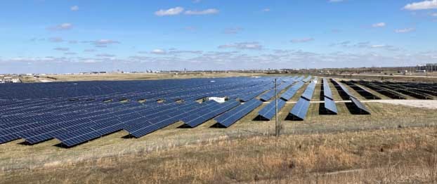
Solar Panel Farms
By Alyssa Damiano, Division of Water
Solar energy is an alternative that has continued to gain popularity throughout Indiana. As of 2015, fifteen counties in Indiana had adopted and implemented solar ordinances in congruence with the implementation of solar panel farms (Indiana Model Solar Ordinance, 2020). If possible solar farms should be located outside of the floodplain, however the solar ordinance does not give guidance for solar farms proposed in the floodplain. The DNR does have general guidelines for local officials to follow if this happens.
Construction design plans are required to be submitted to communities with all elevation details of the panels horizontal and vertical tilt. Solar farm plans must meet all community design standards and adhere to landscape or vegetative requirements. The plans also need to comply with local building, electrical, plumbing, utility codes, local floodplain ordinances, and other applicable standards.
Solar farms located in the floodway are required to get DNR approval and permits before local permits can be obtained. In the floodway and fringe, any electrical equipment located onsite must be elevated in conformance with the community’s floodplain ordinance and located at the flood protection grade (FPG) or base flood elevation (BFE) plus two feet. If electrical equipment is located inside a structure, it can be dry floodproofed using flood resistant materials. When panels are in full tilt, they should be at or above the FPG.
All panels and equipment in the floodway and fringe need to be constructed of flood resistant materials and anchored to resist floatation, collapse, or displacement. When solar farms are located solely in the fringe, only local permits are required. The plan design requirements are the same for the fringe as in the floodway. However, if a local official has a question about the design plans, they should contact DNR. A solar and wind farm fact sheet is being drafted now and will be released soon.
 Letters of Map Change
By Doug Wagner, Division of Water
Letter of Map Change (LOMC) is a general term used to describe map actions/corrections that can be accomplished by letter. They include the Letter of Map Amendment (LOMA), Letter of Map Revision (LOMR) and Letter of Map Revision based on Fill (LOMR-F).
LOMA means an amendment by letter to the currently effective FEMA map that establishes that a structure, parcel, or portion of the parcel is not located in a Special Flood Hazard Area (SFHA) through the submittal of property specific elevation data. A LOMA is only issued by FEMA. If requesting a portion of the parcel to be removed the applicant must include a metes-and-bounds description for the portion of the parcel to be removed.
A LOMR is an official revision to the currently effective FEMA map. It is issued by FEMA and changes flood zones, delineation, and elevations. LOMRs typically include an annotated map panel attached to the letter that signifies the changes.
LOMR-F means an official revision by letter to an effective NFIP map. A LOMR-F provides FEMA’s determination concerning whether a structure or parcel has been elevated on fill above the Base Flood Elevation (BFE) and excluded from the SFHA.
There may also be “Conditional” Letters of Map Revision (CLOMR) with other types being CLOMR-F and CLOMR-FW. A CLOMR is a determination based on proposed development that the map may be changed based on documents received. A CLOMR request also requires the “as-built” documentation be submitted upon the completion of the project to ensure the development was completed as designed and previously submitted. Once the “as-builts” and any other documentation is reviewed and approved the LOMR, LOMR-F, or LOMR-FW is issued.
LOMRs use different application forms depending on the type of removal. The MT-EZ is the most common and used for a single structure, parcel, or portion of a parcel and referred to as a LOMA. Elevation and location information is required on the MT-EZ to determine if the structure or parcel is above the BFE. When removing a portion of a parcel the form also requires a metes-and-bounds survey description be attached to the application. The MT-EZ is also used for the LOMA “Out-As-Shown” process when aerial photography clearly shows that a structure or parcel is outside of the SFHA and elevation data is not required.
MT-1 is used for multiple parcels, structures, conditional approvals (CLOMRs), and removals based on placement of fill (LOMR-F) requests. Local officials may rarely see the MT-1 but may need to refer to it to obtain the Community Acknowledgement Form when it is necessary.
The MT-2 form is used for riverine structures such as bridges, culverts, dams, dikes, and levees. This form should be used with any bridge/culvert replacement or installation of new when the hydraulic and hydrologic analysis shows a change in BFE. The hydrologic and hydraulic studies are required to be submitted with the form but first must be reviewed and approved by DNR, Division of Water.
The application form and instruction can be found on FEMA’s website: fema.gov/flood-maps/change-your-flood-zone/paper-application-forms. When downloading the forms make sure to download and review the instructions as well. The address for forms submittal has changed from what is on the application forms MT-EZ and MT-1. FEMA’s preferred method of application is electronically. Anyone can use the Online LOMC at fema.gov/online-lomc once they create an account. Licensed professionals are encouraged to use the eLOMA process at hazards.fema.gov. There are also tutorials and other helpful information on the website.
Operation Stay Afloat
By Doug Wagner, Division of Water
The 10th biennial Operation Stay Afloat was held on March 16. It was a pleasure to see many of you in person for the event. Although not highly attended, it was good to see so many familiar faces and be in-person rather than over the computer screen or phone.
Presentations included: Introduction to Indiana’s Hazard Mitigation Assistance Program, The New Indiana Floodplain Information Portal, Dam Inundation Map App, FEMA Region V Updates, Bridging the Gap between Mitigation and Response, Structure Level Floodplain Analysis and Flood Elevation Points in Indiana, Introduction to Flood Insurance Through the NFIP, Tippecanoe County Flood Inundation and Impacts Tool and IDOH Roles Regarding Floods and Floodways.
We had several partners at the event who set up displays and had helpful handouts. This year’s displays were: Voluntary Organizations Active in Disasters (VOADs), FEMA Region 5, Indiana Association for Floodplain and Stormwater Management (INAFSM), IDHS and Silver Jackets, IDEM, USDA-NRCS, and The American Red Cross. DNR Division of Water had displays from several sections to include: Water Rights & Use, Resource Assessment, and Floodplain Management. The Division also had live demonstrations of its Dam Breach Inundation App and the new Indiana Floodplain Information Portal.
I would like to thank all those that participated, presented, or provided/staffed a booth/display for contributing to the success of the conference.
Upcoming Training Opportunities

(Information from FEMA, ASFPM, and other websites)
Association of State Floodplain Managers (ASFPM)
ASFPM has an online training program and new training is added regularly. See floods.org/training-knowledge-center/ for more information.
FEMA’s Emergency Management Institute (EMI)
In-person classes are resuming at EMI after most had been canceled or held virtually last year. EMI still offers many courses through webinar training opportunities. Currently E0273: Managing Floodplain Development thru the NFIP, is scheduled for June and July of 2022. For additional information on EMI classes and webinars, please visit EMI’s training calendar website at training.fema.gov/emicourses/schedules.aspx and its course catalog at firstrespondertraining.gov/frt/npccatalog/EMI.
STATE TRAINING OPPORTUNITIES
Other Upcoming Events and Training
For other upcoming events and training hosted by the DNR Division of Water, check out our events and training page on our website dnr.IN.gov/water/events-and-training. We will be posting training videos and other opportunities as they are developed or scheduled.
DNR Division of Water will be presenting Variances and the NFIP on June 14 from 9 to 11 a.m. ET, and June 15 and 21 from 2 to 4 p.m. ET. All these events will be virtual Teams meetings. The workshop will also be held as a hybrid event on June 22 from 10 a.m. to noon ET in conference room 22 of the Indiana Government Center South. These workshops should be attended by local floodplain administrators, board of zoning appeals members, and any planning, zoning, and building staff. You can register for the event at forms.office.com/g/nY1iKeQWAw.
Indiana Department of Homeland Security
Please visit the Indiana Department of Homeland Security’s training calendar for upcoming courses and trainings at oas.dhs.IN.gov/hs/training/public/calendar.do.
|
THANK YOU
Thanks to those contributing to this issue: Dave Knipe, Anita Nance, Darren Pearson, Alyssa Damiano, Marty Benson, Scott Roberts, Don Kaczorowski, and Ed Reynolds.
Editor – Doug Wagner
The work that provides the basis for this newsletter was supported by funding under a cooperative agreement with the Federal Emergency Management Agency. The author and publisher are solely responsible for the accuracy of the statements and interpretations contained in the publication. Such interpretations do not necessarily reflect the views of the federal government.
Waterlines is produced quarterly as a public service by the DNR Division of Water.
Waterlines is available on the Web at dnr.IN.gov/water/publications/waterlines-newsletter/.

Having trouble viewing this email? View it as a Web page.
|