An introduction to the Division of Water’s Dam Breach Inundation Area Web App
By Garth A. Lindner, Division of Water
A 2017 incident in California prompted the evacuation of 180,000 people downstream of the Oroville dam, the tallest in the United States. Fortunately, it did not fail, but multiple deficiencies and uncertainties pertaining to the dam and the risks posed were identified1. The 2020 failures of the Edenville and Sanford Dams in Michigan caused the evacuation of over 11,000 people in the middle of the night. The dam embankment failure of the Edenville dam from soil liquefaction caused an uncontrolled release of the entire impounded reservoir, which subsequently caused the failure of the downstream Sanford Dam from dam embankment overtopping2. In response to these incidents, dam safety officials across the nation have renewed calls to increase awareness and understanding of the risks posed by dams.
As part of this effort, The US Army Corps of Engineers (USACE) has recently approved the publication of dam breach inundation maps through the National Inventory of Dams (NID)3. From the release, “USACE-generated inundation maps assist with modeling, exercise scenarios, emergency planning, and community preparedness. USACE also supports our partners through programs such as Floodplain Management Services, Silver Jackets, and Planning Assistance to States to develop inundation maps for non-USACE infrastructure to support flood preparedness activities.4” The USACE publishes dam information for over 90,000 dams across the nation through the NID database5.
With this guidance and support from our national partners, the Dam and Levee Safety Section within the Division of Water (DOW) at the Indiana Department of Natural Resources published a web application (app) in November called Dam Breach Inundation Area6. This app is provided through ArcGIS Online Services. On this app, the user can view jurisdictional dams in the state of Indiana, and the accompanying areas downstream of the dam that would be inundated if failure occurred. Presently, 140 of the 869 dams in the online database have breach maps associated with them. Included in this app are various layer options that can be added to improve viewing, including multiple years of aerial imagery, a topographic layer, a roads layer, and more. Also available are tools that can be used to explore this app, including a measurement and drawing tool, various print to image and pdf functions, and tools for sharing generated maps with other parties.
The sharing of this information through the DOW’s Dam Breach Inundation Area app will increase flood risk awareness for communities and the public while also empowering users, including emergency responders, to make more-informed decisions during flood events. The methods to create this database are based on best-available data and industry standard practices. In the coming months and years, the Dam and Levee Safety Section will be posting additional breach maps to this app as they are created, both by private agents and department staff. Direct access to the new app is available here: Dam Breach Inundation Area. Alternatively, access the new app through the updated Dam and Levee Safety Section website.
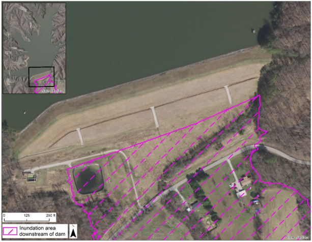 Figure 1: Aerial image of an earthen dam in Indiana, and the potential inundation area immediately downstream of this dam from an uncontrolled dam breach. Note the two houses within this flood footprint, which extends much further downstream, but is shown at this scale to improve interpretation.
References:
- France, J., Alvi, I., Dickson, P., Falvey, H., Rigbey, S., and Trojanowski, J. (2018). Independent Forensic Team Report for Oroville Dam Spillway Incident. https://damfailures.org/case-study/oroville-dam-california-2017/.
- France, J., Alvi, I., Williams, J., Miller, A., and Higinbotham, S (2021). Independent Forensic Team Interim Report, Investigation of Failure of Edenville and Sanford Dams. https://damsafety.org/MI-Interim-Report.
- Engineering Circular 1110-2-6075 (October 1, 2020). Inundation Maps and Emergency Action Plans and Incident Management for Dams and Levee Systems. https://www.publications.usace.army.mil/USACE-Publications/Engineer-Circulars/.
- USACE, Headquarters (January, 25, 2021). USACE Publishes Policy Update for Inundation Maps and the National Inventory of Dams. https://www.usace.army.mil/Media/News-Releases/News-Release-Article-View/Article/2483323/usace-publishes-policy-update-for-inundation-maps-and-the-national-inventory-of/.
- USACE (2020). National Inventory of Dams, More than 90,000 dams nation-wide. https://nid.usace.army.mil/#/.
- Indiana DNR (2021). Dam Breach Inundation Area. https://indnr.maps.arcgis.com/apps/webappviewer/index.html?id=509929365726496d841fcc6d06335381.
 Violation
By Doug Wagner, Division of Water
Violation means the failure of a structure or other development to be fully compliant with your community’s local flood hazard ordinance.
Local officials may occasionally come across or are made aware of violations in their local community. When it is determined that a violation does exist, the official needs to be proactive in pursuing correction or mitigation of it.
Sometimes the violation may have existed for a few years or more and it will be more difficult to correct it since documentation may not be readily available. Other times it may be as simple as issuing an “after-the-fact” permit providing the development is compliant with the local ordinance.
Whether a violation is recent or older the local official, often referred to as the Floodplain Administrator, will need to issue a letter or other documentation to the property owner. The letter will need to cite the violation and the code/ordinance section/s that they are in violation of. It should also provide possible resolution to the violation, which can come in many different forms.
Is the violation a structure or other development? Structures must have the lowest floor at the flood protection grade, have utilities elevated, be anchored to resist flotation, collapse or displacement, and other requirements depending on the type of structure. You can refer to the local ordinance to determine what requirements must be met, which will depend on type of development and location in the Special Flood Hazard Area (SFHA).
Is the development in the fringe or floodway? The key difference between the two areas is any development in the floodway requires a permit or authorization from DNR prior to commencement of development activities. Keep in mind that if the development is in the floodway, DNR authorization is required prior to the local permit being issued.
Participation in the National Flood Insurance Program (NFIP) requires that communities permit all development in their SFHAs. To ensure communities are permitting development correctly, FEMA or DNR on FEMA’s behalf conducts community assistance visits or community assistance contacts to monitor the local permitting activities.
Division of Water Staff Changes
By Alyssa Damiano & Dave Knipe, Division of Water
Some staff changes have taken place in the Division of Water.
David B. Knipe P.E., CFM has been appointed as Director of the Division of Water and began his duties in that position on Oct. 31.
“Hello! I am writing this introductory message as the new Director of the Division of Water. I am succeeding Ryan Mueller, who was promoted to Deputy Director of the DNR in May. I earned a B.S. in Civil Engineering from Pennsylvania State University and my M.S. in Civil Engineering from Purdue University. I’m also a licensed Professional Engineer in Indiana and a Certified Floodplain Manager. I have served the DNR about 30 years and have been an influential figure in hydrology and hydraulic engineering, management of federal grant projects, and a notable figure in water resources management. I, along with the Division of Water team, have led Indiana to be a national leader in flood risk communication and floodplain management by creating extensive floodplain mapping resources.
The Division of Water is committed to serve the water resources and floodplain management community in the State of Indiana. If there are ideas, issues, or concerns that you’d like to bring to my attention, please don’t hesitate to do so. I can be reached at dknipe@dnr.IN.gov. Thank you for all you do in making Indiana more resilient to flood damage and in protecting the natural resources of the state.”
On Nov. 15, Sarah Black joined the Floodplain Management Section.

Sarah has been assigned responsibility for the NFIP communities in the southern region of the state. She received her bachelor’s degree from Northern Illinois University in 2017. Sarah has held positions with MD Logistics, National Weather Service, Indianapolis office, and Northern Illinois Access. Most recently she worked as an Emergency Preparedness Coordinator with the Indiana Department of Homeland Security. In her spare time Sarah enjoys exploring new places with her dog, hanging out with friends, and watching holiday movies. Welcome Sarah!
|
Congratulations to New CFMs
By Doug Wagner, Division of Water
After completing the exam at the INAFSM Conference in September, two new Certified Floodplain Managers (CFMs) were added to the growing list of floodplain management professionals across the nation. The most recent additions are Chelsea Cottingham of Whiteland and Benjamin Stanley of Goshen.
This national program for professional certification of floodplain managers was established by the Association of State Floodplain Managers, and the first exam was offered nationally in 1999. The program recognizes continuing education and professional development that enhances the knowledge and performance of local, state, federal and private-sector floodplain managers.
The CFM program also ensures the Division of Water has highly qualified individuals to meet the expanding challenges of increasing disaster losses in our changing climate now and in the future. CFMs reduce community liability, promote safer development, know how to reduce flood insurance premiums and property damage, help improve water quality, advise wise land-use, are trusted local advisors, and abide by a Code of Ethics. Becoming a CFM provides individuals with professional credibility, networking opportunities with other professionals in the field, continuing education opportunities, and higher potential for advancement.
Congratulations Chelsea and Benjamin on your achievement.
|
Upcoming Training Opportunities

(Information from FEMA, ASFPM, and other websites)
Association of State Floodplain Managers (ASFPM)
ASFPM has an online training program and new training is added regularly. See floods.org/training-knowledge-center/ for more information.
FEMA’s Emergency Management Institute (EMI)
In-person classes are resuming at EMI after most had been canceled or held virtually last year. EMI still offers many courses through webinar training opportunities. Currently E0273: Managing Floodplain Development thru the NFIP, is scheduled for January, April, June, and July of 2022. For additional information on EMI classes and webinars, please visit EMI’s training calendar website at training.fema.gov/emicourses/schedules.aspx and its course catalog at firstrespondertraining.gov/frt/npccatalog/EMI.
STATE TRAINING OPPORTUNITIES
Other Upcoming Events and Training
For other upcoming events and training hosted by the DNR Division of Water, check out our events and training page on our website dnr.IN.gov/water/events-and-training/ We will be posting training videos and other opportunities there as they are developed or scheduled.
Save March 16 for Operation Stay Afloat 2022. Operation Stay Afloat is a biennial one-day conference for hazard mitigation at the state government center. You can register for the event at forms.office.com/g/3TdWsQV8xc. Event updates will be posted on our training page as they develop.
Indiana Department of Homeland Security
Please visit the Indiana Department of Homeland Security’s training calendar for upcoming courses and trainings at oas.dhs.IN.gov/hs/training/public/calendar.do.
|
THANK YOU
Thanks to those contributing to this issue: Dave Knipe, Anita Nance, Darren Pearson, Alyssa Damiano, Garth Lindner, Moumita Mukherjee, Marty Benson, Scott Roberts, Don Kaczorowski, and Ed Reynolds.
Editor – Doug Wagner
The work that provides the basis for this newsletter was supported by funding under a cooperative agreement with the Federal Emergency Management Agency. The author and publisher are solely responsible for the accuracy of the statements and interpretations contained in the publication. Such interpretations do not necessarily reflect the views of the federal government.
Waterlines is produced quarterly as a public service by the DNR Division of Water.
Waterlines is available on the web at dnr.IN.gov/water/publications/waterlines-newsletter/.
Having trouble viewing this email? View it as a Web page.
|