Indiana Floodplain Information Portal (INFIP) 2.0
By Doug Wagner, Division of Water
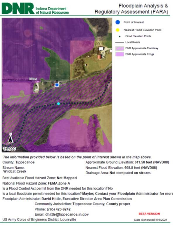
The portal has been a great tool for more than a decade and it is getting a new look. INFIP 2.0 will be similar to many other mapping applications. It is an ArcGIS web app that is very user-friendly and simple to use. INFIP 2.0 will reduce the current wait time for the Floodplain Analysis and Regulatory Assessment (FARA) from 60-90 days to a matter of minutes. The report that is generated by the system is the FARA for the site. However, you will also have an opportunity to file for a DNR review of the site if you want to contest the floodplain information provided in the FARA.
 Examples of Floodplain Mapping
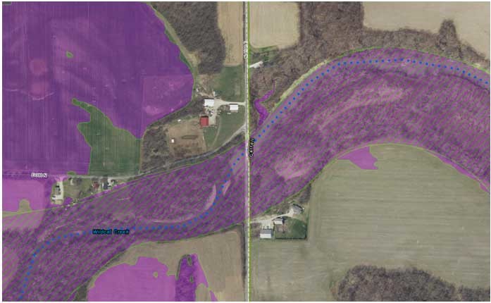
Effective
- Users can view the effective Flood Insurance Rate Map by turning the layer on
- Used for Regulatory and Flood Insurance purposes
- FARA required for any development and flood insurance in a Zone A
 FIRM effective Zone A
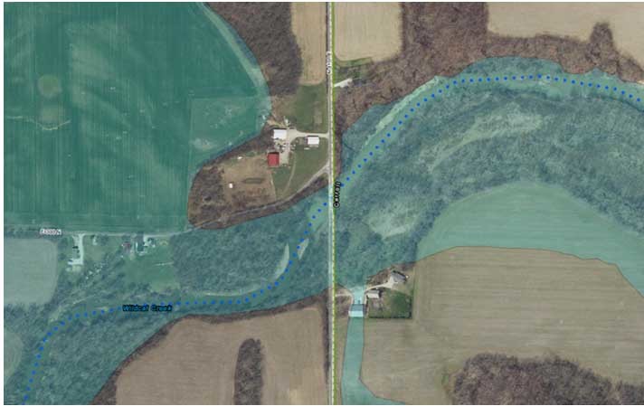
Best Available
- Based on LiDAR data and improved modeling through the use of this information
- Used for regulatory purposes where FEMA maps show Zone A or are unmapped
- The application is defaulted to this layer
 Best available showing floodway and reducing floodplain fringe
Go to the INFIP Website: infip.dnr.in.gov (once version 2.0 is live)
- A Floodplain Analysis and Regulatory Assessment (FARA) is required for local floodplain permitting and FEMA Letter of Map Amendment applications in A zones or unmapped areas
- A FARA is also required for regulatory determination when the upstream drainage area is greater than 1 square mile
- Base Flood Elevation (BFE) determinations are often used for proposed development, compliance determinations and flood insurance purposes
- The Indiana Floodplain Information Portal (INFIP) displays the Best Available Floodplain mapping as well as the BFE
- A Floodplain Analysis and Regulatory Assessment (FARA) can be printed or downloaded directly from the site
Selecting a Site
- Zoom to the site by viewing the imagery
- Enter the property address in search box and click on magnifying glass or hit enter at top left of page
- Verify the site is the correct location
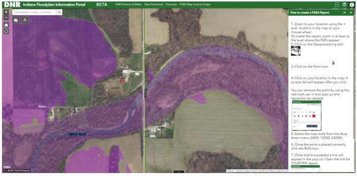
How to obtain a Floodplain Analysis and Regulatory Assessment (FARA)
- Enter an address or pan and zoom to the exact site of the determination
- Examples: parcel of land, existing residence, proposed development
- Open the toolbox feature icon as instructions on the right indicate
- Select the point icon from the toolbox
- Place a point on the map
- Select the map scale, then click run
- In a few moments a link will appear to a PDF version of the FARA
- Select the link to print, download or email
- You may also request a staff review of the site if you have any questions; follow directions if needed
- The FARA is based on the point selected and a new report should be run if the site location changes
- Maintain a copy of the FARA report permanently for permitting or other purposes
- It is the responsibility of the user to maintain a copy of the FARA. DNR, Division of Water will not have a copy of the FARA
Other features
- Links in the header
- DNR Division of Water website
- Data Download page for current Best Available Floodplain Layer
- Overview (DNR Story Map)
- FEMA Map Service Center
- Legend
- Layer List
- Provides the option of turning layers on or off
The Indiana Department of Natural Resources is a proven partner to FEMA with a history of providing, maintaining, and improving floodplain management services throughout the State. In partnership with FEMA the DNR’s Division of Water has implemented and updated a state-of-the-art Indiana Floodplain Information Portal (INFIP). This application operates as a web-based portal that integrates DNR’s internal applications and databases with enhanced flood mapping repositories and information delivery. The application offers user-friendly internal and external mechanisms for better supporting the National Flood Insurance Program compliance and risk awareness, a key objective of FEMA’s Risk MAP program. This application also serves as a “proof-of-concept” for FEMA’s latest vision for Regulatory Products. Combined, these elements are helping Indiana rise as one of the nation’s premier Cooperating Technical Partners.
2021 INAFSM Conference
By Doug Wagner, Division of Water
The Indiana Association for Floodplain and Stormwater Management (INAFSM) hosted its 25th Annual Conference, Sept. 15-17. This year’s conference marked a return to in-person events, as the conference was held at the Old National Events Plaza in Evansville.
The conference had an excellent offering of educational classes and sessions.
INAFSM again presented awards to recognize member achievement at the reception dinner on Wednesday evening.
Excellence in Stormwater Management was presented to Chris Jones, who created the stormwater utility for the city of Greenwood. Under his direction, the city opened a nature center to demonstrate the importance of environment, created programs to work with the public, and completed numerous stormwater infrastructure improvements around the city.
The Outstanding Stormwater Project was the Norwaldo Neighborhood Stormwater Improvements. The project owner is the city of Indianapolis DPW/ Engineering and project consultant was the HNTB Corporation. When the neighborhood was built in the 1960's, almost no stormwater infrastructure was built as the neighborhood was established. The project included permeable pavers, rain gardens and other aspects of green infrastructure that ultimately provided stormwater relief to approximately 30 blocks of residents in the city. This project removed standing water and provided new infrastructure to almost 600 homes in the Norwaldo neighborhood.
Excellent Strides in Floodplain Management award was presented to Kim Hostetler, CBI, CFM of Huntington County. Kim administers the ordinances for the county and five other communities within it. Three of the communities and the county participate in the CRS program and are level nine communities.
Excellence in Floodplain Management award went to Doug Wagner, CFM, Senior Planner, DNR Division of Water, Floodplain Management Section. Doug has expanded the workshop opportunities and at the direction of the State NFIP Coordinator has changed the Waterlines newsletter from a biannual to a quarterly publication. The virtual workshops during the pandemic had twice the attendance in a virtual presentation verses the “in-person” workshops prior to the pandemic. This was accomplished by staggering offering times and additional offerings. Doug also arranged virtual meetings for the Maumee River Basin Commission in his role as technical liaison.
The Outstanding Floodplain Project award went to the Waterways Permitting website, a joint effort between both IDEM and DNR that tells an applicant what permits are required from each agency for a project submittal. Once an applicant submits the project information, they will receive a joint response from both agencies on what permits are required from each of them within 15 days.
The Outstanding Education/Outreach Award was presented to both City of Bloomington Utilities and Candi Donaldson – Hendricks County Partnership for Water Quality.
The final award was the Chairman’s Award for Outstanding Service in Support of the INAFSM. Zach Beasley presented this award to Greg Lake, REHS/RS for his efforts drafting the new articles of incorporation for the organization. Greg also served as Vice Chair of INAFSM.
|
Mitigation and Resources
By Doug Wagner, Division of Water
Mitigation is the process of making something less severe, dangerous, painful, harsh or damaging. In the context of flood mitigation, we consider the removal, repair, retrofitting or conversion of structures or infrastructure to increase an individual’s or community’s resiliency to future flooding events. By mitigating local hazards communities can more readily and easily recover after a disaster occurs. According to the National Institute of Building Sciences 2019 Mitigation Saves Report, for every federal grant dollar spent on mitigation activities, six dollars are saved in future recovery and repair costs.
Mitigation is an activity that many communities do well, yet others may be challenged in finding the resources to carry out these types of projects. The overall process is often lengthy and time consuming, involving identification of proposed projects, planning, identifying possible funding sources, grant submissions, and execution of proposed activities. In June, FEMA released new guidance and resources for local communities that are contemplating mitigation activities. This guide provides highlights of many different funding sources for different mitigation project projects. You can review the various funding sources here: fema.gov/about/organization/region-5/mitigation-funding-resource-guides.
Take Your CFM Exam Online: More Convenient, Faster Results
By Mary Bart, Association of State Floodplain Managers (ASFPM)
Big changes are coming to the Certified Floodplain Managers exam. After two years of planning, we’re excited to announce the transition to a digital CFM® exam has begun. Candidates can begin scheduling their online exams.
Moving to an online format provides greater convenience and flexibility to the more than 1,200 floodplain management professionals who take the CFM exam each year. There will be no more having to wait for an exam date to be scheduled in your community or traveling an hour or more to take an exam in a neighboring state. As an added benefit, you will receive your results immediately upon completion of the exam, rather than the typical two or three-week turn-around time of the paper exams.
ASFPM has contracted with Scantron, a leading testing services company, to make the CFM exam available at its test center locations in the United States and Canada. Of the top 100 U.S. cities by population, 98% of candidates are within 15 miles of a Scantron testing center. For even greater convenience, there’s also the option of taking the exam from your home or office with Scantron’s remote proctor service.
“This really is a major milestone for the CFM program and it will help us continue to grow the program while protecting the security and integrity of the exam,” said Chad Berginnis, executive director of ASFPM. “By removing the barriers inherent to the traditional paper exams, we anticipate the accessibility of the digital exam will hold particularly strong appeal to the next generation of CFMs.”
Timeline for the digital exam transition To accommodate exam takers during the transition to a digital exam, the Certification Board of Regents (CBOR) has established a phased rollout for the program. Here are a few key points to keep in mind as you plan your testing options:
- Digital exams can be scheduled now
- Existing paper exams that are already scheduled will go on as scheduled
- ASFPM will begin pilot testing digital exam offerings at chapter events later this year
- Paper exams are targeted to be phased out in 2022
Getting started with the digital CFM exam Registering for the online CFM exam is quick and easy. When you register here to take the exam, you will receive a Notice to Schedule email from Scantron that includes a username/password and instructions to register at a testing center that meets your preferred location and timeframe. You can adjust your location/timeframe search as needed to get more options. A list of testing locations can be found here.
The cost to take the national CFM exam is $185 for members and $565 for non-members.
To help you navigate the changes, we’ve developed a resource of frequently asked questions. Ready to get started? Visit our website to learn more and register for your exam.
“Moving to the digital exam is part of our ongoing effort to modernize the CFM program,” said Louie Greenwell, certification and training manager at ASFPM. “In addition to the convenience and flexibility aspects, candidates will enjoy a better test-taking experience as things like FIRM maps and other exhibits are easier to display in a digital format.”
Reprinted with permission from the Sept. 2021 issue of The Insider, a publication for ASFPM members. Learn more at floods.org.
Division of Water Staff Changes
By Doug Wagner, DNR

The Division of Water has gone through several staff changes this year.
In May, Division of Water Director Ryan Mueller was promoted to Deputy Director of DNR’s Regulatory Bureau. In this new role Ryan oversees activities for the Divisions of Entomology & Plant Pathology, Historic Preservation & Archaeology, Reclamation, & Water. Ryan had served as division director since October 2017.
In August Alyssa Damiano joined the Floodplain Management Section.
Alyssa has been assigned responsibility for the NFIP communities in the northern region of the state. She received her bachelor’s degree from Indiana University’s O’Neil School of Public and Environmental Affairs in December of 2020. While at IU she specialized in environmental and sustainability studies with a focus on water, natural resource management, food systems, and community development. In her spare time Alyssa enjoys riding bikes, hanging out with friends, going to the lake (Lake Michigan), and knitting. Welcome Alyssa!
|
Upcoming Training Opportunities

(Information from FEMA, ASFPM, and other websites)
Association of State Floodplain Managers (ASFPM)
ASFPM has an online training program, and training is added regularly. See floods.org/training-knowledge-center/ for more information.
FEMA’s Emergency Management Institute (EMI)
In-person classes are resuming at EMI after most had been canceled or held virtually during the last year. EMI offers many courses through webinar training opportunities. Currently E0273: Managing Floodplain Development thru the NFIP, is scheduled for November 2021, and January, April, and June of 2022. For additional information on EMI classes and webinars, please visit EMI’s training calendar website at training.fema.gov/emicourses/schedules.aspx and its course catalog at firstrespondertraining.gov/frt/npccatalog/EMI.
STATE TRAINING OPPORTUNITIES
Other Upcoming Events and Training
For other upcoming events and training hosted by the DNR Division of Water, check out our new events and training page on our website dnr.IN.gov/water/events-and-training/ We will be posting training videos and other opportunities there as they are developed or scheduled.
Indiana Department of Homeland Security
Please visit the Indiana Department of Homeland Security’s training calendar for upcoming courses and trainings at oas.dhs.IN.gov/hs/training/public/calendar.do.
|
THANK YOU
Thanks to those contributing to this issue: Ryan Mueller, Kenneth Smith, Jon Eggen, Anita Nance, Darren Pearson, Alyssa Damiano, Mary Bart, Alysson Oliger, Marty Benson, Scott Roberts, Don Kaczorowski, and Ed Reynolds.
Editor – Doug Wagner
The work that provides the basis for this newsletter was supported by funding under a cooperative agreement with the Federal Emergency Management Agency. The author and publisher are solely responsible for the accuracy of the statements and interpretations contained in the publication. Such interpretations do not necessarily reflect the views of the federal government.
Waterlines is produced quarterly as a public service by the DNR Division of Water.
Waterlines is available on the web at dnr.IN.gov/water.
Having trouble viewing this email? View it as a Web page.
|