When It Rains, It Floods
By Casey Kenworthy, Indiana Department of Homeland Security
article reprinted from Hoosier Responder-October 2020
According to the NOAA National Severe Storms Laboratory (NSSL), flooding is the most common weather-related natural disaster in the United States and kills more people each year than tornadoes, hurricanes, or lightning. Despite Indiana experiencing more than 200 different flooding and heavy rain events during 2019, only 19,700 flood insurance policies are in effect within the state. While purchasing flood insurance might seem costly, the National Flood Insurance Program (NFIP) is available to help Hoosier homeowners and renters mitigate losses caused by flood disasters.
The National Flood Insurance Program (NFIP), offered through the Federal Emergency Management Agency (FEMA), is designed to reduce the impact of flooding by providing affordable flood insurance policies to property owners, renters and businesses around the country. Only homeowners in high-risk flood areas (also known as “floodplains”) with mortgages from federally regulated lenders are required to purchase flood insurance. Although it is not required for everyone, flood insurance is something every Hoosier can benefit from.
“Everyone lives in a floodplain. It is just a question of how much flood water it takes to impact their structures and property," said Mary Moran, branch director of the Indiana Department of Homeland Security (IDHS) Response & Recovery Division. "No home is completely safe from the risks of flooding."
In 2019, Indiana received more than $670,000 in flood damage claims paid out from FEMA. In 2018, however, severe flooding during February and March caused individual damage to exceed $19 million.
The DNR is the state agency responsible for reviewing, regulating, and establishing floodplains in Indiana. According to its Floodplain Management in Indiana Quick Guide, as of April 2018 two Indiana counties and 72 municipalities are flood prone. but do not participate in the NFIP or enforce floodplain management regulations.
“The NFIP is a voluntary program, so communities have to agree to adopt and enforce a floodplain management ordinance,” said Darren Pearson, Indiana DNR’s NFIP coordinator. “We have approximately 450 communities in Indiana that participate in the NFIP, but there are also many smaller communities located in minimal floodplains that currently do not participate.”
James Sink, regional flood insurance liaison with FEMA, said flood insurance claims in FEMA Region 5 low-floodplain areas have proportionally increased by more than 20 percent from 1978 to 2020.
Unfortunately, Indiana is not a part of that increase.
“People in Indiana tend to purchase flood insurance only if their mortgage requires them to, so overall there has not been a lot of policy growth in that state,” Sink said. “This is largely because Indiana does not have as many high visibility flooding events as its neighboring states.”
Despite the state’s low rate of high visibility flooding events, heavy rainfall is reason enough for Hoosiers to consider purchasing flood insurance.
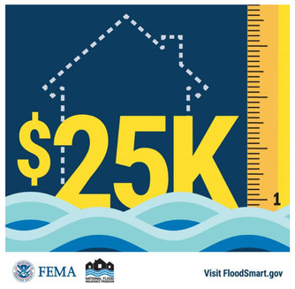
“In Indiana, people need to think about their flood risks differently,” he said. “It’s not necessarily the river flooding, but the high impact rainfall events can lead to an inch of water that causes up to $25,000 in damage.”
Hoosier communities interested in learning more about flood risks in their area should visit DNR’s Indiana Floodplain Information Portal. This floodplain mapping application utilizes both FEMA and DNR approved floodplain data resources and provides the best available, comprehensive coverage of floodplain information for the state of Indiana.
Hoosiers interested in learning more about purchasing flood insurance through the NFIP can visit floodsmart.gov.
 |
 No Adverse Impact
By Doug Wagner, Division of Water
What is No Adverse Impact or NAI as many floodplain administrators refer to it?
No Adverse Impact is a methodology used only allowing activities that could adversely impact flood damage to another property or community to the extent that the impacts are mitigated or have been accounted for within an adopted community-based plan.
NAI is a concept, policy or strategy that broadens one’s focus from the built environment to include how changes to that environment, anticipated development and changes in rainfall events potentially impact other properties. When implemented, it broadens property rights by protecting those that would be adversely affected by the actions of others. A NAI approach to floodplain management is a way to protect the public, private property owners and future generations. It takes into account the built environment, future development and cumulative effects of development on watersheds protecting the rights and use of property for everyone.
Several communities across the state already implement a portion of this concept by having adopted a compensatory storage requirement in their local floodplain ordinance. The compensatory storage requirement requires property owners to create a compensatory storage area when they place fill or other obstructions in the floodplain. In most communities, the required ratio is 1:1. However, there are some communities with a 2:1 or 3:1 ratio locally. This means the fill or obstruction placed is mitigated or has no effect on the storage capacity of the flood hazard area for the community.
There are also communities that have adopted permeable surface requirements for parking areas, driveways and sidewalks. With this requirement, water is allowed to soak in, reducing the actual speed and amount of runoff discharged into the stream, decreasing flood flows.
It is recommended that a community adopts a NAI policy or approach to their floodplain regulations on a watershed level. Doing this may include adjoining communities that are in the same watershed. Using this approach improves s resiliency to flooding and better overall water quality in multiple communities.
When a properly implemented NAI approach to watershed development or floodplain management is used, it strengthens the community’s overall resiliency to flooding, provides better water quality, and protects them from possible litigation. For more information on NAI, litigation and property rights, you can visit ASFPM’s NAI resources here. ASFPM has many resources that further discuss this approach, “how-to-guides”, toolkits and papers.
 |
2020 INAFSM Conference
By Doug Wagner, Division of Water
The Indiana Association for Floodplain and Stormwater Management (INAFSM) hosted its 24th Annual Conference virtually Sept. 16-18.
The conference still had a good offering of educational classes and sessions, despite its virtual setting. If you missed the conference, you can register before Dec. 31 and view the recorded sessions through the end of March. For further details, go to INAFSM.
INAFSM again presented awards to recognize member achievement at the end of the conference.
The first award was Excellent Strides in Floodplain Management presented to David Knipe, P.E,, CFM, from the DNR Division of Water. The award was presented for the work of DOW in creating the Best Available Floodplain Layer, Story Map, and the individual meetings that were held with each of the 92 counties.
|
The Outstanding Stormwater Project was the Fluvial Erosion Hazard Mitigation Manual. The project owner was Matt Crouch, from the Office of Community and Rural Affairs. Consultants were Christopher B. Burke Engineering, Ltd. and IUPUI-CEES.
The Outstanding Floodplain Project award went to Kankakee River Basin and Yellow River Basin Development Commission for the development of the Kankakee River Flood and Sediment Management Work Plan. Scott Pelath is the Executive Director and the consultant was Christopher B. Burke Engineering, Ltd.
The Outstanding Education/Outreach Award was presented to Laporte County Stormwater Program for the development of several educational videos and social media postings, and the number of hits they have had on them. Staff that developed and posted the videos were Rick Brown, MS4 Coordinator and Ariana Woodson, Assistant Coordinator.
Excellence in Floodplain Management went to Rodney Renkenberger, Executive Director, MRBC. Renkenberger provides consultations to surveyors, local floodplain administrators, and property owners. Under his leadership, the commission has bought out over 300 homes in flood hazard areas and a nursing home using the Hazard Mitigation Grant Program, restoring the areas to open space. The commission also annually does flood awareness videos and ads on a local TV station in the commission’s territory.
Excellence in Stormwater Management was presented to Jim Knapp, Purdue University, for his leading role in the joint Tippecanoe County MS4 Program since 2003.
The Lifetime Achievement Member Award was presented to Toni Cecil, Town of Muncie Sanitary District. Toni has held committee and board positions with INAFSM and also developed several forms for others to use in their duties. She will be retiring from her position on Nov. 13.
The final award was the Chairman’s Award for Outstanding Service in Support of the INAFSM. Zach Beasley presented this award to the entire 2020 annual conference planning committee for their dedication and efforts to move the event to a virtual format, rescheduling bookings of event centers for this year and the next three years and still producing an excellent conference. Each of the committee members will be individually listed on the plaque.
CONGRATULATIONS TO NEW CFMS
By Doug Wagner, Division of Water
After completing the exam at the State Government Center on Oct. 1, two new Certified Floodplain Managers (CFMs) were added to the growing list of floodplain management professionals across the nation. The most recent additions are Robyn Toole, Indianapolis, and Daniel Kekacs, Columbus, Ohio.
This national program for professional certification of floodplain managers was established by the Association of State Floodplain Managers, and the first exam was offered nationally in 1999. The program recognizes continuing education and professional development that enhances the knowledge and performance of local, state, federal and private-sector floodplain managers.
The CFM program also ensures we have highly qualified individuals to meet the expanding challenges of increasing disaster losses in our changing climate now and in the future. CFMs reduce community liability, promote safer development, know how to reduce flood insurance premiums and property damage, help improve water quality, advise wise land-use, are trusted local advisors, and abide by a Code of Ethics. Becoming a CFM provides individuals with professional credibility, networking opportunities with other professionals in the field, continuing education opportunities and higher potential for advancement.
Congratulations Robyn and Daniel on your achievement.
|
Conditional Letter of Map Revision
By Doug Wagner, Division of Water
Recently the Division of Water began sending notices to applicants, agents, and local floodplain administrators (FPAs) when review of construction in the floodway permit application indicated that a rise would occur in the floodway of a stream.
While any DNR approval meets the criteria set forth in IC 14-28-1 and 312 IAC 10, these notices serve as notification of federal regulations, 44 CFR 60.3 (d) (4), that apply to projects such as these, where the encroachment in the floodway causes any increase in base flood elevations.
44 CFR 60.3 (d) (4) Notwithstanding any other provisions of § 60.3, a community may permit encroachments within the adopted regulatory floodway that would result in an increase in base flood elevations, provided that the community first applies for a conditional FIRM and floodway revision, fulfills the requirements for such revisions as established under the provisions of § 65.12, and receives the approval of the Administrator.
Communities that participate in the National Flood Insurance Program (NFIP) have, at a minimum, adopted the minimum federal and state requirements for floodplain management. When a proposed project will cause an increase in the base flood elevations as published in the community’s Flood Insurance Study, the community must ensure that application has been made to the Federal Emergency Management Agency (FEMA) for conditional approval of such action, and the approval received prior to permitting the project locally.
By ensuring that a Conditional Letter of Map Revision (CLOMR) from FEMA is received prior to issuance of the local permit, a community will protect itself from being cited for a violation after the project is completed. There have been instances where a community did not receive the CLOMR prior to permitting a project and was later cited with a violation by FEMA. Communities should also ensure that the development that takes place under the permit is in compliance with the conditions of the CLOMR as applied for. This may require use of an outside consultant or engineering firm to verify the conditions have been met. Once the project is complete, the community should also require the applicant to apply for and obtain a Letter of Map Revision (LOMR) prior to issuance of a local compliance certificate for such a project.
The process may seem a bit cumbersome, but it ensures more accurate flood hazard data and protects communities from being cited with violations of this requirement. Resolving violations when the proper procedures have not been followed in the beginning can be quite difficult and time consuming. Sometimes they are unable to be resolved without removal of the development and restoration of the site to pre-development condition. Restoration or site mitigation may be quite expensive and, in some cases, may not be possible, so it is better to follow proper procedures at the start of the project than to wait until a violation is cited.
Fair Market Value
By Ray Carroll, MAI, SRA, CFM
Reprinted with permission from the Association of State Floodplain Managers (ASFPM). Learn more at www.floods.org.
Today I’m covering the appraisal challenges associated with determining the market value for use in making NFIP-required substantial improvement and substantial damage determinations. Specifically, I want to focus on the adjusted assessment method. As the default method used most often, it deserves more than a passing glance.
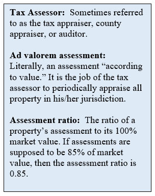
Let’s begin by understanding that ad valorem tax assessments were never intended to be used the way we use them for SI/SD determinations. This method is popular because it is quick, inexpensive, and manageable by community officials, and it usually works for modest repairs or improvements.
All of the following conditions must be met when the adjusted assessment method is used:
- The building must be assessed (not all buildings are)
- You must know the assessment that applies to the “under-roof” portion of the building
- You must know the assessment ratio
- You must make the adjustment mathematically correct.
Let’s assume we’re considering a proposal to improve someone’s house with a detached two-car garage and an attached swimming pool and pool enclosure. Elsewhere on the property is a boat dock, a paved driveway, and a tool shed. Assessments are developed using a computer model that starts with a land value estimate. When there are improvements, their replacement costs are estimated and deductions are made for depreciation. In this case, the house and its attached pool and pool enclosure would have the costs grouped together, and separate costs would be estimated for the rest of the improvements. When you’re evaluating an application to improve the residence, only the value of that building applies. That’s why it’s important to ask for the assessment that applies to the under-roof portion of the building you’re interested in.
Most assessment information available online is not in a useable format. That means we need to do more work, because it’s our job to get the right information. Here’s how to do that:
- Before you do anything else, contact the local tax assessor’s office and ask to talk to someone about the assessment ratio. The data processing division is a good place to start. Explain how you’re using the assessment information and then ask, “What is the assessment ratio for XYZ County?” Most assessments are set at a fraction of market value. This is to avoid overassessment and resulting lawsuits. Usually there is a targeted assessment percentage set by statute. Sometimes a state agency that audits assessments will require local tax assessors to file a formal report setting forth the assessment percentage for a given jurisdiction. Once you learn how things are done in your jurisdiction, get a copy of whatever document certifies the assessment percentage. It should be a public document, and you’ll only need to ask for it once a year when the new tax roll is certified.
- Develop a personal contact at the local tax assessor’s office who you can talk to or email regularly. I say “develop” because you’re likely to have to explain what you want and what you’re doing. If you’re patient, and you take time to develop a relationship, then it will save you time later when you email other requests.
- When you make a request for assessment information, identify the property (probably using a property tax ID #), and ask for “the assessment that applies to the under-roof portion of the building.” This is the only way to be sure you have the correct assessment.
- Once you know the assessment ratio, and you have the correct assessment information, it’s just easy math to use the adjusted assessment method, you divide the building assessment by the assessment ratio. Here’s how the math works:
Assume the building assessment is $85,000 and the assessment ratio is 0.85:
$85,000 ÷ 0.85 = $100,000, which is the building value.
[Careful. Don’t multiply by the assessment ratio. For this example, that yields $85,000 × 0.85 = $72,250.]
For as often as this method is used, we should use it properly and have confidence in the results. Though the adjusted assessment method is simple and easy to use, we should be aware that it has some major drawbacks:
- It is common across the country to find places where assessments are set at very low percentages. Assessment ratios as low as 30% or 35% are not uncommon. The lower the ratio, the more sensitive the adjustment process becomes, and the less reliable the outcome is.
- Assessments always lag the actual market because there must be a supply of recent sales activity for the assessor to build the assessment database. In jurisdictions that reappraise annually, it is possible that assessment information is as much as 18 months old, but many communities don’t reappraise annually. Some reappraise no more often than every five years. That means you’d be working with an assessed value that is more than five years old.
- Not all buildings are assessed. For example, condominium units are assessed individually, and the assessment does not separate the land value. Neither does it separate other common-element improvements, all of which are included in each unit’s assessment. The adjusted assessment method should never be applied to condominium ownership situations. Other buildings, especially if they are exempt from property taxes, are sometimes not assessed with the same attention to detail as tax-paying property. This is especially true of government buildings. There are some buildings that aren’t separately assessed because they are part of a larger whole. A good example is the clubhouse in a packaged golf community.
Commentary
By, Doug Wagner, Division of Water
Although the article above makes some good points it is important for Floodplain Administrators look further into Indiana’s assessment structure when determining market values for structures. Indiana assesses properties as a “market-value-in-use” assessment. Each county will reassess approximately 25% of its parcels each year, with all properties being adjusted annually based on community trends in the market.
Trend factors are derived from research/review of sales in the area of the subject property for the two years prior to the Jan. 1 valuation date. There is also a verification/validation process that properties undergo when they are sold to ensure that the assessment reflects each property’s characteristics at the time of sale. You may notice that in some communities, property assessed values are very close to the market value yet others may seem short of market value.
There are a number of factors that may influence this such as neighborhood classification, water frontage, or even recent area sales. It may also be that the property owner filed an appeal that was upheld by the review board and had their property value decreased.
Local administrators will want to develop relationships with their local assessors and/or appraisers to get a better idea of what the market value is in relationship to the assessed value. These relationships can provide you a better understanding of how the assessments are done and what the “market value” of properties are in your community. For more information on property assessment in Indiana see DLGF’s website.
|
Upcoming Training Opportunities

(Information from FEMA, ASFPM, and other websites)
Association of State Floodplain Managers (ASFPM)
ASFPM has an online training program, and training is added regularly. See floods.org/training-knowledge-center/ for more information.
FEMA’s Emergency Management Institute (EMI)
The E0273 course, Managing Floodplain Development Through the NFIP, is scheduled at EMI on the following dates: Nov. 30-Dec. 3, Jan. 4-7, 2021, Feb. 1-4, 2021, June 28-July 1, 2021 and Aug. 30-Sept. 2, 2021. Dates are subject to change due to COVID-19 restrictions and guidance.
EMI also offers many courses through webinar training opportunities online. For additional information on EMI classes and webinars, please visit EMI’s training calendar website at training.fema.gov/emicourses/schedules.aspx and its course catalog at www.firstrespondertraining.gov/frt/npccatalog/EMI.
Other Trainings and Conferences
Virtual Workshops – December 2020
The Floodplain Management Section will be providing a two-hour workshop on Dec. 1 and 9. The workshop will be “Post-Flood Guidance and Substantial Damage.” The workshop will be held at 9 a.m. and 2 p.m. each day. A separate announcement and registration link will be sent out soon.
Indiana Department of Homeland Security
Please visit the Indiana Department of Homeland Security’s training calendar for upcoming courses and trainings at oas.dhs.IN.gov/hs/training/public/calendar.do
|
THANK YOU
Thanks to those contributing to this issue: Ryan Mueller, Anita Nance, Darren Pearson, Wanda Gaines, Jerod Evans, ASFPM, Casey Kenworthy, Marty Benson, Scott Roberts, Don Kaczorowski, and Ed Reynolds.
Editor – Doug Wagner
The work that provides the basis for this newsletter was supported by funding under a cooperative agreement with the Federal Emergency Management Agency. The author and publisher are solely responsible for the accuracy of the statements and interpretations contained in the publication. Such interpretations do not necessarily reflect the views of the federal government.
Waterlines is produced biannually as a public service by the DNR Division of Water.
Waterlines is available on the web at dnr.IN.gov/water.

Having trouble viewing this email? View it as a Web page.
|