|
ENDANGERED SPECIES ACT and COMMUNITY COMPLIANCE
By Darren Pearson and Doug Wagner, Division of Water
One question we receive frequently is about compliance to the Endangered Species Act (ESA). In particular, we get this question when a local Floodplain Administrator (FPA) is asked to sign off on the Community Acknowledgement Form associated with a Letter of Map Change (LOMC) application. When considering development in the floodplain, communities and developers should ensure they communicate and coordinate with the appropriate National Marine Fisheries Service (NMFS) or United States Fish and Wildlife Service (USFWS) regional or field office. Communities and developers should also take into consideration the following ESA requirements when making land-use decisions:
Section 9 of the ESA prohibits the taking of listed species. Taking is defined as harassing, harming, pursuing, hunting, shooting, wounding, killing, trapping, capture, or collection of ESA species, or attempting to engage in any such conduct. Harm includes significant habitat modification or degradation that results in death or injury to ESA species by significantly impairing behavioral patterns such as breeding, feeding, or sheltering. Harass is defined as actions that create the likelihood of injury to ESA species to such an extent as to significantly disrupt normal behavior patterns that include, but are not limited to, breeding, feeding or sheltering (50 C.F.R. §17.3).
Section 10(a)(1)(B) of the ESA allows non-federal parties to apply for an incidental take permit for activities that could result in the incidental taking of ESA listed species. The application must include a habitat conservation plan that describes the proposed actions, determines the effects of those actions on ESA species and their habitats, and defines measures to minimize and mitigate adverse effects. We recommend contacting your local USFWS or NMFS office for assistance with the Habitat Conservation Program permitting process.
On May 25, 2018 a Record of Decision (ROD) was published in the Federal Register. Then, on or about March 5, 2019, FEMA sent out a notice of the decision to all communities participating in the National Flood Insurance Program (NFIP). A short summary of the ROD is that local communities will be required to comply with the ESA for all permits issued in their Special Flood Hazard Areas (SFHAs). This requirement still applies even if there is no intent to file for a LOMC. Basically, FEMA will be modifying the NFIP regulations to more clearly state that communities must follow ESA requirements for all permits issued in the SFHA.
Below a summary and explanation is provided for both sections of the community acknowledgement form.
A. REQUESTS INVOLVING THE PLACEMENT OF FILL As the community official responsible for floodplain management, I hereby acknowledge that we have received and reviewed this Letter of Map Revision Based on Fill (LOMR-F) or Conditional LOMR-F request. Based upon the community's review, we find the completed or proposed project meets or is designed to meet all of the community floodplain management requirements, including the requirement that no fill be placed in the regulatory floodway, and that all necessary Federal, State, and local permits have been, or in the case of a Conditional LOMR-F, will be obtained. For Conditional LOMR-F requests, the applicant has or will document ESA compliance to FEMA prior to issuance of the Conditional LOMR-F determination.
For LOMR-F requests, I acknowledge that compliance with Sections 9 and 10 of the ESA has been achieved independently of FEMA’s process. Section 9 of the ESA prohibits anyone from “taking” or harming an endangered species. If an action might harm an endangered species, a permit is required from USFWS or NMFS under Section 10 of the ESA. For actions authorized, funded, or being carried out by Federal or State agencies, documentation from the agency showing its compliance with Section 7(a)(2) of the ESA will be submitted.
In addition, we have determined that the land and any existing or proposed structures to be removed from the SFHA are or will be reasonably safe from flooding as defined in 44CFR 65.2(c), and that we have available upon request by DHS-FEMA, all analyses and documentation used to make this determination. For LOMR-F requests, we understand that this request is being forwarded to DHS FEMA for a possible map revision.
In Section A.,
1. The local FPA is acknowledging that the project met all of the community’s floodplain management requirements including that no fill was placed in the floodway and that all necessary Federal, State, and Local permits were obtained. This should be done already as part of the permit process.
- If for a Conditional LOMR-F, the local FPA is acknowledging that the proposed project will meet all of the community’s floodplain management requirements including that no fill was placed in the floodway and that all necessary Federal, State, and Local permits will be obtained.
2. The local FPA is acknowledging that the project is in compliance with Section 9 and 10 of the ESA. To verify this, the applicant should provide either: a permit from USFWS (if there is an impact to an endangered species) or a letter from the USFWS stating that the project is in compliance with Sections 9 and 10 of the ESA (no endangered species are impacted). You can obtain the contact information for USFWS offices in Indiana. The applicant should contact the Indiana office for their area.
- If for a Conditional LOMR-F, the applicant has to document ESA Compliance prior to issuance of the Conditional LOMR-F.
3. To determine that the land and any existing or proposed structures to be removed from the SFHA are or will be reasonably safe from flooding, the local official should refer to Technical Bulletin 10.
- Many communities in Indiana require the applicant to provide a certification from a professional engineer that states the project is reasonably safe from flooding. The communities then use the certification as their documentation to verify that the site is reasonably safe from flooding.
All three parts of Section A. need to be met before the community acknowledgement form can be signed. All documentation should be maintained in local records for NFIP compliance.
B. PROPERTY LOCATED WITHIN THE REGULATORY FLOODWAY As the community official responsible for floodplain management, I hereby acknowledge that we have received and reviewed this request for a LOMA. We understand that this request is being forwarded to DHS-FEMA to determine if this property has been inadvertently included in the regulatory floodway.
We acknowledge that no fill on this property has been or will be placed within the designated regulatory floodway.
We find that the completed or proposed project meets or is designed to meet all of the community floodplain management requirements.
In Section B.,
1. The FPA needs to verify that no fill has been placed or will be placed in the floodway.
2. The FPA is stating that the project meets all of the community’s floodplain management regulations. This should have be done earlier as part of the local permit process.
- If for a Conditional LOMR-F, the FPA is agreeing (after a complete review) that the proposed project is designed to meet all of the community’s floodplain management regulations.
Both parts of Section B. need to be met before the community acknowledgement form can be signed. All documentation should be maintained in local records.
 Critical Facilities
Chad Berginnis, Executive Director, Association of State Floodplain Managers
Floodplain administrators are faced with permitting all kinds of development, from fences to large industrial or institutional facilities. Recently, FEMA posted a fact sheet related to temporary critical facilities and floodplain considerations. This fact sheet is a reminder of one particular type of development that demands the highest level of review and consideration, critical facility.
What is a critical facility?
A facility/development/action for which ANY threat of flooding is too great
OK, so what exactly does that entail? Well, it could be a lot of things. That is why, instead of an exhaustive list of specific facility types, it is easier to define critical facilities by their impacts:
- Critical to the community’s public health and safety, especially during a flood event
- Essential to the orderly functioning of a community
- Storage or production of materials that are highly volatile, toxic, or explosive
- Facilities where occupants may be insufficiently mobile to avoid loss of life or injury (this would encompass many COVID-19 related facilities)
- Facilities that, when flooded, would create an added dimension to a disaster
- Facilities that, when damaged, can impact the delivery of vital services
Examples of critical facilities include, but are not limited to, emergency service facilities (i.e., fire stations or emergency operations centers), hospitals, retirement homes/senior facilities, major roads and bridges, critical utility sites (i.e., electrical substations, water/wastewater treatment facilities), and hazardous storage facilities.
What are appropriate standards for siting/protecting critical facilities?
Where possible, critical facilities should simply not be sited where there is any risk of flooding; however, adhering to that standard is not as easy as it sounds because most community flood maps do not show all flood risks. And other communities may simply not have any sites that are not flood prone. So with that, there is a hierarchy that should be followed:
- Identify all flood hazards that may affect a proposed site for a critical facility. Start with your Flood Insurance Rate Map, but do not end there. Is the site in a dam failure zone? Is it in an area protected by a levee? What is the protection level of the levee? Is there a small stream, drainage way or conveyance of flood water in any proximity to the site? Is the site in a hurricane surge zone or tsunami zone that may not be on a FEMA flood map? Does the site have a history of flooding or standing water? What about high groundwater that could cause surface water flooding for long durations? It is very important that due diligence is exercised at this point. If any type of watercourse goes through or near the site, its flood hazard areas should be studied and mapped.
- Do not place a critical facility on a site prone to flooding, ever. Ideally, this also means using the future conditions floodplains (not just the present condition 100- or 500-year floodplain). Future conditions are an especially important consideration in areas subject to sea level rise.
- If you must construct or improve a critical facility on a flood-prone site, at the minimum it should be protected/resilient to is the 500-year level or flood of record, whichever is greater.
Other siting considerations include means of access to the facility – is there only one means of access to the facility or are there multiple means? Is that means of access flood prone? Also, if the facility must be located in an area with some measure of flood risk, flood water velocity, debris, and erosion should be considered.
Where can I find out more?
There are several excellent resources on critical facilities. If you wanted to learn more about the origins of the concept of critical facilities then the two page section on Critical Actions in the Further Advice on Executive Order 11988 publication produced by the Water Resources Council in the 1980s is a must read. FEMA has three detailed design publications that go in-depth on different aspects of critical facilities:
Also, the DNR Division of Water’s Floodplain Management Program can provide additional guidance and information on critical facilities.
UPDATES TO TECHNICAL BULLETIN 1:
Requirements for Flood Openings in Foundation Walls and Walls of Enclosures
By Wanda Gaines, Division of Water
With the construction of any new structure within an identified Special Flood Hazard Area (SFHA), there are minimum protection requirements required by FEMA set forth in Code of Federal Regulations (CFR), Chapter 44. One of the main requirements is that the structure is constructed to be protected up to the Base Flood Elevation (BFE). One method of protection is elevating the structure in a way so that the lowest floor is located at or above BFE. Often, property owners wish to enclose the space below the elevated living floor to provide additional storage space for low value items (e.g., lawn care equipment) and for parking vehicles. Enclosing this space requires the installation of openings to prevent buildup of hydrostatic pressures that could damage the structure. FEMA has recently updated the Technical Bulletin (TB) 1, which provides the guidance and requirements for these flood openings.
One of the updates is the inclusion of a table that summarizes the American Society of Civil Engineers (ASCE) 24 standards and International Code Council (ICC), International Residential Code (IRC) and International Building Code (IBC), and compares them to the National Flood Insurance Program (NFIP) requirements. The table provides information detailing as to whether the building codes are equivalent or exceed NFIP requirements. The table also notes updates that have been made to the IRC every few years, providing a brief description of the changes.
The updates have also provided enhanced guidance on the placement of flood openings, particularly in situations where the placement of openings could be difficult. One such situation would be buildings where the foundational walls are placed into sloping sites. The property owner must ensure that the lowest side of the structure is at or above the exterior grade across the entire length so as not to be considered a basement per NFIP standards. Otherwise, the construction will be considered non-compliant and will cause the NFIP premiums to be higher than necessary. Note that the bottom of each opening must be no higher than 1 foot above the interior or exterior grade, whichever is higher. Another instance of where flood opening placement may be problematic is in townhouses with limited exterior walls. NFIP requirements state that at least two openings must be located on a minimum of two exterior walls. If the flood openings cannot be installed in at least two exterior walls, the NFIP does allow all the openings to be installed in one wall, provided they are located below the BFE. Other situations that are covered in the updated Technical Bulletin are structures with an interior grade higher than the exterior grade, buildings with large enclosed areas, buildings with multiple enclosed spaces, and structures located in areas of shallow flooding.
Within the updated TB 1, there is clearer guidance to address how engineered flood openings are to be recorded on an Elevation Certificate (EC). If it is noted on the EC that the flood openings are engineered, then the required engineered flood opening documentation must be attached. The documentation must either be the ICC-Evaluation Services (ES) Evaluation Report or a certification that is signed and sealed by a registered design professional who is licensed in the same state where the structure is located. The manufacturer and model number of the engineered flood openings should also be noted in the comments section of the EC.
There have been multiple updates to the Technical Bulletin overall, many of which have just been briefly touched on within this article. A complete copy of the updated TB 1 can be accessed in a PDF format on FEMA’s website found here: TB-1
UPDATES TO TECHNICAL BULLETIN 5:
Free-of-Obstruction Requirements
By Jerod Evans, Division of Water
We live in a time unprecedented in its changing conditions. There is uncertainty in the atmosphere and unfortunately, this is speaking of the physical atmosphere as well as the social and financial ones. There are many studies that cite uncertainty in our climate and weather patterns as we know them. Seasonal storms seem to be growing stronger over time. With this apparent advent of storms of greater magnitude, large bodies of water like the Great Lakes are making waves and encroaching farther on land with more thunderous force. Therefore, in late 2019 FEMA announced that Coastal High Hazard Zones (Zone V) will be added to the northernmost communities of Indiana that border Lake Michigan.
With these important changes taking place within communities in norther Indiana, the guidance of FEMA Technical Bulletin (TB) 5 is all the more important for the people of these communities. Unfortunately, the waves that are produced in Zone V can cause a great amount of damage to structures that are not properly engineered. This TB provides guidance on the National Flood Insurance Program’s (NFIP) free of obstruction requirements in addition to other standards required by FEMA that are set forth in Code of Federal Regulations (CFR), Chapter 44, plus helpful information for building in Zone V. Fortunately, TB 5 was recently updated in March of 2020, a project that revealed pleasant changes in format as well as providing greater detailed guidance on many issues addressed in this resource. One of the differences that the new technical bulletin offers is the addition of new side notes that flush out helpful information, such as the impacts of obstructions, facts about below-base flood elevation (BFE) requirements, standards for erosion control structures, and the requirements for design certification in Zone V, to name a few.
The plethora of further information also has a revised section on areas that are enclosed below the elevated building to which they are attached, such as louvers and lattices. This includes a greater degree of illustrations and even equations to be used to figure out the percentage of open area for these additions to the structure. There is even a new section on two level enclosures that are composed of appropriate vents and breakaway walls. It breaks down the correct engineering for these structures and the regulations that they must abide by. For example, two leveled enclosures must have a supporting floor that has floor grate drainage, and the flood vents still have to be 1 foot or less above the floor system on the second level.
In terms of accessory structures, the new bulletin revised some of the language having to do with detached garages and goes into further detail on pools and spas that are not covered by the NFIP but do have regulations attached to them. The new technical bulletin has a large table added that compares NFIP requirements to International Residential Code (IRC) and International Building Code (IBC) and how they have changed over the years. There is revised information on fill requirements as well.
In conclusion, the updates to Technical Bulletin 5 are many. These updates go into greater detail about a vast number of regulations and challenges that one could have to contend with when building in Zone V. They not only make the bulletin more informative, but the changes in format and additions of up-to-date illustrations make the document easier to read and follow. The updated copy of FEMA TB 5 can be accessed in PDF form at FEMA’s website found here: TB-5
Accessing the Division’s Database
By Doug Wagner, Division of Water
You can now check the status of permits and violations through the public side of the Division of Water’s database. The database can be accessed at: DOW UNITY. Keep in mind it is always a good idea to clear your browser history frequently so these sites will work better.
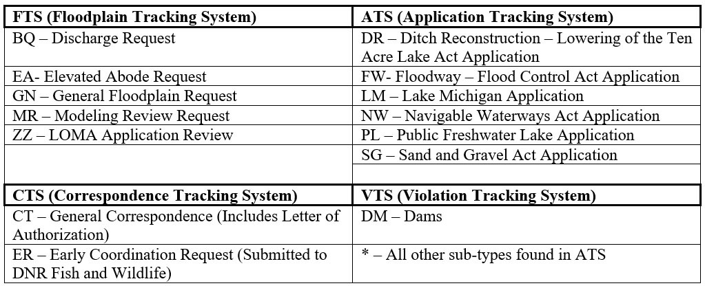
In order to look up more information about a file, go under the "Regulatory" tab, then "Application Tracking System (ATS)", “Floodplain Tracking System (FTS)”, “Correspondence Tracking System (CTS)”, or “Violation Tracking System (VTS)” tab on the left-hand side of the screen. The floodplain tracking system files have sub-types that begin with BQ, EA, GN, MR, or ZZ. See the table below for the designations for each of the tracking systems.
 If you are unsure of the file number, you can look it up on the Division of Water’s Online Research Center (DoWORC) ON.IN.GOV/DOWORC An overview of the site can be found on our flyer www.in.gov/dnr/water/files/wa-Online_Research_Center.pdf
Once you’ve selected the tracking system in the database, you can enter the sequence and click on ‘search.’ If more than one record appears as a result of the search, the most recent record will be on top and the records will be separated by sub-type. Click on the desired record to view the record. Once you have the record up, you will use the “menu” dropdown (on the upper right side of the screen) to view the site location information or other information about the file. The information for an application will be under “attachments”, including permit applications and other documents in this file. The person assigned to the file is the “Point of Contact” and that information is located under the “Status” menu. If an action has not been completed, many of the records will not be available until the file is closed. FTS and CTS files that pre-date the database may not be available to the public. For information concerning files that predate the database, or if you are having difficulties viewing attachments, please contact the Division of Water at water_inquiry@dnr.IN.gov.
INDIANA FLOOD CONTROL ACT:
Amendments to IC 14-28-1
By Doug Wagner, Division of Water
The Indiana Flood Control Act (IC 14-28-1) was enacted in 1945 after severe flooding, loss of life and destruction of property in the floods of 1913 and 1937. The Indiana Department of Natural Resources, then the Natural Resources Commission, began issuing permits for development in the floodway in the early 1950s. Over the years, the act has been amended from time to time as it was deemed necessary and beneficial to the citizens of the state. Earlier this year, the Indiana state legislature took on the task of reviewing and amending the Indiana Flood Control Act once again.
On March 18, 2020, Governor Holcomb signed Senate Enrolled Act No. 433, amending IC 14-28-1-23. The amendment adds requirements in sub-section (c) to Section 23. The text of the amendment is:
(c) Beginning January 1, 2020, the director shall not exercise the authority under subsection (a) to remove or eliminate an abode or residence from a floodway if:
(1) the abode or residence was constructed before January 1, 2020;
(2) the owner of the abode or residence has taken necessary measures to elevate the lowest floor of the abode or residence, as reconstructed, including the basement, to at least two (2) feet above the one hundred (100) year flood elevation within two (2) years after receiving notification from the department concerning the abode or residence; and
(3) the owner of the abode or residence has taken necessary measures to comply with all applicable local, state, and federal floodway regulations.
Frequently Asked Questions about the Act may be:
Does the amendment “grandfather” any structures?
The amendment does not “grandfather” any structures. It simply provides a mechanism for an owner for the opportunity to bring the structure into compliance with this statute and other regulations rather than having to remove it. Upon notice that an abode or residence is located in a floodway, the owner will be provided two years to bring the property into compliance with the statute.
Will these structures be permitted, become lawful or authorized?
If a property owner has been notified by the Department of Natural Resources that the residence or abode must be brought into compliance with the specific set of requirements noted in sub-items 1-3, a permit or letter of authorization from the DNR will be required. Prior to beginning work, the property owner should contact the DNR to discuss their plans for bringing the residence or abode into compliance and get a determination from the DNR as to whether the proposed work will require a Construction in a Floodway Permit or can be done under a Letter of Authorization.
How is the two-year date of compliance determined?
The two-year date for compliance is two years from the date of notification. This runs with the property and does not get extended through a sale or transfer of the property. All prospective purchasers or transferees MUST be notified of the deadline date prior to the transfer to or purchase by another owner.
Can I relocate my abode or residence outside of the regulatory floodway?
An unauthorized residential structure in a floodway may still be relocated outside of a floodway if the owner wishes. This is always a safer option and may, in some cases, be financially beneficial.
Will following the requirements of the statute amendment make the abode or residence safer from flood or less likely to receive damage during a flood?
The amendments in no way make your property safer or less likely to suffer severe flood damage. Implementing the requirements is intended to provide a reasonable measure of protection against flood damage during flood events; however, these measures do not guarantee that the structure will not suffer flood damage. The floodway is a high-risk area where floodwaters generally move with greater velocities that can quickly compromise a structure’s integrity. Particularly if the foundation has not been engineered specifically to withstand flood forces and the impact of debris, damage can occur. Additionally, safe access is typically an issue during flood events.
In spite of the new amendment, your property may still flood; floods occur regularly although some may be less than, equal to or greater than the 100-year regulatory level. You may experience property damage, and you or others may experience loss of life if present during a flood event.
If I elevate, will I still need to be rescued during a flood?
Very likely, yes. Residents occupying residential structures should always be watchful of flood watches/warnings and evacuate when authorities advise. Rescues during flood events present high risks, both to those performing the rescues and to those in the process of being rescued. It may become too dangerous to even attempt a rescue.
What are other local, state, and federal regulations that may be applicable?
The local jurisdictional authority may have a floodplain ordinance, zoning ordinance or other regulations that are more stringent than the state or federal regulations. If so, those will take precedence. Federal and state regulations are minimum standards, and local communities are encouraged to adopt more restrictive regulations.
The property will have to have a lawful septic system or connection to a public sewer system. State law prohibits a septic system to be installed within a floodway or a floodplain below the regulatory flood elevation (BFE) under regulations of the Indiana State Department of Health (ISDH). There may also be other requirements under the Indiana Department of Environmental Management (IDEM) or various divisions within the Indiana Department of Natural Resources (DNR).
For properties that are in the floodway as mapped on a Flood Insurance Rate Map (FIRM), the Federal Emergency Management Agency (FEMA) requires a “no rise” certification for any development within the floodway. There may be other requirements under the Environmental Protection Agency (EPA), U. S. Army Corps of Engineers (USACE), and U. S. Fish and Wildlife Services (USFWS).
Does the amendment apply to new or proposed residences or abodes?
This amendment only affects an abode or residence constructed prior to January 1, 2020. New residences or abodes are not allowed in floodways under the statute. More information on permitting requirements in floodways and waterways in Indiana can be found at Waterways Inquiry
IDEM and DNR Announce New Waterways Inquiry Request
Reprint of joint news release March 9, 2020
The Indiana Department of Environmental Management (IDEM) and Department of Natural Resources (DNR) are tasked with implementing state and federal laws to protect the natural resources and scenic beauty of Indiana waterways, including their chemical, physical, and biological integrity, as well as their quality, flow, and capacity. Many times, Hoosiers do not know when or if they need a permit to complete a project in a floodway, stream or wetland on their property. To help answer that question, the two agencies have partnered to create the Waterways Inquiry Request now available at the new website: waterways.IN.gov.
The Waterways Inquiry Request is a helpful tool, not a requirement. The agencies created the Waterways Inquiry Request to help landowners who are unfamiliar with the permitting process determine which application and waterways permits may be required for a potential project. The Waterways Inquiry Request prompts landowners to outline the boundary of their project on a map, asks a series of questions about the proposed area of disturbance, and requests general information about the project. Once the request is electronically submitted, an inquiry review will be completed by staff from both agencies, and applicants will receive an emailed response within 14 days. The email response not only provides which permits, if any, are needed, but also provides feedback from IDEM and DNR staff to the applicant in preparation for the application process.
The new Indiana Waterways website provides step-by-step written and video instructions for submitting a Waterways Inquiry Request along with additional links and information about the permitting process. Permit applications, along with a new joint IDEM/DNR application for activities requiring permits from both agencies, are also available.
TRAINING OPPORTUNITY

Permitting Development in Special Flood Hazard Areas
The DNR Division of Water’s Floodplain Management Section will be hosting webinars on June 17. The first offering will be at 9 a.m. and a second will be at 1 p.m. Both webinars will cover the same information: local ordinance requirements, application review, and necessary documentation for permitting developments in Special Flood Hazard Areas (SFHAs). Please mark your calendars and join us for one of these events. Each webinar will be about 90 minutes in length and may be limited on the number of attendees. More details and the meeting link will be distributed soon. Certified Floodplain Managers can earn continuing education credits for participating. To register, email dwagner1@dnr.IN.gov with your chosen time.
|
THANK YOU
Thanks to those contributing to this issue: Chad Berginnis, Ryan Mueller, George Bowman, Anita Nance, Darren Pearson, Wanda Gaines, Jerod Evans, Marty Benson, Don Kaczorowski, Ken Smith, Jon Eggen, Alysson Oliger, and Ed Reynolds.
Editor – Doug Wagner
The work that provides the basis for this newsletter was supported by funding under a cooperative agreement with the Federal Emergency Management Agency. The author and publisher are solely responsible for the accuracy of the statements and interpretations contained in the publication. Such interpretations do not necessarily reflect the views of the federal government.
Waterlines is produced biannually as a public service by the DNR Division of Water.
Waterlines is available on the web at dnr.IN.gov/water.

Having trouble viewing this email? View it as a Web page.
|