|
THE ELEVATION CERTIFICATE
By Doug Wagner, Division of Water
The Elevation Certificate (EC) is a form that most floodplain managers are familiar with. This simple six- page document is used or completed by several disciplines for a host of reasons.
Floodplain Administrators (FPAs) use them to fulfill compliance requirements in accordance with their local ordinance. They must also maintain this information in the permit file permanently. FPAs in CRS communities must also keep this information on file and maintain a 90% accuracy requirement of the program in order to receive full credit points in this area. FPAs must also keep in mind that although the EC will provide most compliance information, nothing substitutes for a physical inspection of the site to verify conditions match what is presented on the certificate. Insurance agents must have a completed EC to properly rate a post-firm or substantially improved pre-firm structure for flood insurance. It may also be advantageous for a property owner with a pre-firm structure to have their property rated by using an elevation certificate rather than the “pre-firm” rating.
The EC may be completed by an engineer, architect, or surveyor who is professionally licensed in each state by FEMA regulations. In Indiana, only an engineer or surveyor may complete the certificate verifying the elevations by statute.
There are many sources of assistance for both local officials reviewing the EC and professionals completing it. The first source are the instructions that accompany the certificate itself that can be found on FEMA’s website Elevation Certificate and Instructions. This form is a fillable PDF that will assist any professional. Next is the floodplain management bulletin on elevation certificates that answers many questions on the certificate FEMA 467.
There are also independent self-study courses offered by the Emergency Management Institute. These courses are: IS-01102, The Theory of Elevation Rating; IS-01105.a; EC Made Easy: Elevation Certificate Overview; IS-01103.a, Elevation Certificate for Surveyors. The courses can be found by doing a search of the independent study site EMI Independent Study. You will need to register for a FEMA student ID before taking any of the courses here: FEMAsid. The independent study courses go into a little more detail than even the instructions for the EC. One example of this is the allowance to omit the garage floor on an attached garage as the lowest floor but, only if it is compliant construction. Compliant construction if below BFE means being constructed of flood resistant materials, properly vented and used only for parking, access to the structure, and/or limited storage. FPAs should keep in mind that the allowance of not providing the attached garage floor elevation as the lowest floor does not remove the requirements under the Indiana Floodplain Rules (312 IAC 10-2-28) and the elevation of the lowest floor for new construction. Another example is the suggestion of using the guidance of the Flood Insurance Manual in the determination of the building diagram for a structure Flood-Insurance-Manual. At the site you can download and view current and historic manuals.
Although the current EC form expired Nov. 30, 2018, FEMA guidance has been to continue use of the form until the new form and instructions are published. It is our understanding the new form will only have a few minor changes or additions to it once published.
THE NFIP AND VARIANCES
By Doug Wagner and Wanda Gaines, Division of Water
Variances are the only legal means by which a community can permit construction or other development that is inconsistent with the provisions of its zoning, flood hazard or other land use ordinances. They may be issued either for a use or area of a particular piece of property. Depending on how a community’s land-use regulations are established, they may or may not be able to grant a use variance. If a community participates in the National Flood Insurance Program (NFIP), it has adopted minimum criteria to follow for floodplain development.
The NFIP has some specific criteria for the granting of variances for properties located in the special flood hazard area that are located in 44 CFR Part 60.6. These criteria are also referred to in a community’s local flood hazard ordinance. However, during some recent community assistance visits (CAVs) or community assistance contacts (CACs), it has been determined that not all communities are taking all of these requirements into consideration when granting variances in their communities. When communities have adopted both zoning and floodplain regulations, they should be administered in concert to promote the general welfare of the public by minimizing the threat from natural hazards to life and property.
Many communities are meeting the requirements under their zoning ordinances for variances but are not meeting the requirements under their special flood hazard ordinance, whether partly or wholly. Flood hazard ordinances are intended to complement or be augmented by the local zoning regulations and not necessarily stand alone. There are many different ways a flood hazard ordinance can be implemented, and each community may be different. The common denominator is that if a granted variance does not meet the requirements of the 44 CFR 60.6, it may trigger either disciplinary actions against a community for non-compliance or increased flood insurance premiums for the property owner, or both.
A good example of difference in justification between floodplain regulations and zoning regulations is an extreme hardship. Under most zoning laws, a financial hardship or health condition of the property owner would be considered exceptional and be justification for a variance. When considering the rules of 44 CFR 60.6, the hardship must be unique to the property itself and the owner’s hardship would not provide proper justification for a variance. Another criteria of the 44 CFR 60.6 is lot size being less than one-half acre, FEMA’s guidance states that for variances granted on lots in excess of one-half acre, significant technical justification is required. One must also be mindful when considering small lots that this also requires that adjoining properties have existing structures constructed at grade and not in compliance with the flood hazard requirements.
The requirement nearly always missed when granting a variance to a community’s flood hazard ordinance is the notification portion. FEMA guidance requires that both the applicant and future owners be notified when a variance is issued with construction below the base flood elevation. The variance will increase risks to life and property and result in increased flood insurance rates. This step requires written documentation be sent to the applicant and it is suggested that this documentation also be recorded and attached to the property’s deed so a future owner is made aware of potentially high flood insurance premiums.
Communities should not issue blanket variances under any circumstances. Blanket variances would be those that provide a variance for all or most of the flood hazard requirements of the ordinance or those issued for multiple lots or an entire subdivision. FEMA guidance is quite clear on the fact that variances are for individual lots and should only be issued to the minimum extent necessary to grant relief. Finally, a community should never issue a variance for construction activities prohibited by state statutes such as no new residential construction in a floodway.
For more detail on the requirements under 44 CFR 60 local administrators should refer to FEMA P-993 Floodplain Management Bulletin: Variances and the National Flood Insurance Program.
 Accessory Structure
By Doug Wagner, Division of Water
Floodplain administrators, building inspectors, and others who review building plans and permit applications, as required for communities that participate in the National Flood Insurance Program (NFIP), must understand what an “Accessory Structure” is. The Indiana model floodplain ordinance defines the terms as follows:
Accessory Structure (appurtenant structure) means a structure with a floor area 400 square feet or less that is located on the same parcel of property as the principal structure and the use of which is incidental to the use of the principal structure. Accessory structures should constitute a minimal initial investment, may not be used for human habitation, and should be designed to have minimal flood damage potential. Examples of accessory structures are detached garages, carports, storage sheds, pole barns, and hay sheds.
The definition shown here and also found in a community’s flood hazard ordinance will most likely differ from the community’s zoning ordinance or building code if they have adopted either of these other regulations. Here is a typical accessory structure definition that you would find in a zoning or building code ordinance: Accessory Building, Structure or Use - One which (a) is subordinate to and serves a principal building or principal use; (b) is subordinate in area, extent, or purpose to the principal building or principal use served; (c) contributes to the comfort, convenience, or necessity of occupants of the principal building or principal use served; and (d) is located on the same lot as the principal building or principal use served, with the single exception of such accessory off-street parking facilities as are permitted to locate elsewhere than on the same lot with the building or use served.
You probably noticed the definition used for an accessory structure under the model flood hazard ordinance has a size limitation. Accessory structures must be 400 square feet or less. The next part of the definition is quite similar to other regulations in stating the structure and/or use is incidental to the use of the principal structure or use on the parcel.
Accessory structures must still follow specific construction requirements and are only exempt from the elevation requirement to flood protection grade (FPG). These structures are required to be properly anchored to prevent flotation and/or displacement during a flood event. They need to have the proper flood openings in them to prevent collapse or other damages due to excessive hydraulic and hydrostatic pressures. Accessory structures must be constructed of flood resistant materials, refer to Technical Bulletin 2 for acceptable materials. They shall not be used for human habitation. Any service facilities such as gas or electrical service for such structures shall be at or above the FPG. Finally an accessory structure shall be constructed or placed on the parcel to offer the minimum resistance to the flow of floodwaters.
The biggest factor for the size consideration is to discourage habitation of these structures. Similarly, we see coastal regulations that limit the size for enclosures below habitable areas for the same reasons. Active enforcement of this provision of the special flood hazard ordinance may prevent future personal injury during a flood event for owners of such structures. Following the size limitation may also prevent future conversions of enclosed “accessory” structure space putting the occupant in harm’s way.
CONGRATULATIONS TO NEW CFMS
By Doug Wagner, Division of Water
After completing the exam at the INAFSM conference in September, two new Certified Floodplain Managers (CFMs) from Indiana were added to the growing list of floodplain management professionals across the nation. The most recent additions are Wanda Gaines of Shelbyville and Timothy Thielka of Mishawaka.
This national program for professional certification of floodplain managers was established by the Association of State Floodplain Managers and the first exam was offered nationally in 1999. The program recognizes continuing education and professional development that enhances the knowledge and performance of local, state, federal and private-sector floodplain managers. This program ensures that we have highly qualified individuals to meet the expanding challenges of increasing disaster losses in our changing climate now and in the future. CFMs reduce community liability, promote safer development, know how to reduce flood insurance premiums and property damage, help improve water quality, advise wise land-use, are trusted local advisors, and abide by a Code of Ethics. Becoming a CFM provides individuals with professional credibility, networking opportunities with other professionals in the field, continuing education opportunities and higher potential for advancement.
Congratulations Wanda and Timothy on your achievement!
|
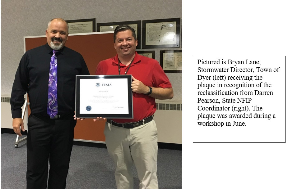
TOWN OF DYER ADVANCES CRS CLASSIFICATION
By Doug Wagner, Division of Water
Congratulations to the Town of Dyer, which increased its classification in the Community Rating System (CRS) program. The Town of Dyer moved from a Class 9 to a Class 8. Bartholomew County also maintained its classification as a Class 8 community. These classifications were effective on May 1, 2019 for the Town of Dyer while Bartholomew County shows May 1, 2009 since they remained a Class 8 community. The reclassification and maintenance classification were part of the communities’ regular verification cycle associated with the program.
 CRS is a program under the NFIP where communities that have adopted higher standards can advance “class” ratings that afford their community members with a discount if they have a standard flood insurance policy. These discounts range from 5% to 45% depending on the activities the community chooses to participate in or other higher standards they adopt. Communities will receive points for activities such as outreach, public education, tracking of permits, and maintaining elevation files for structures in the Special Flood Hazard Areas (SFHA) of the community.
A participating community in the NFIP is classified as a 10. When they enter the CRS program, they will be assessed by FEMA and the CRS specialist from ISO (Insurance Services Offices). Based on the evaluation and verification they are doing the activities they have stated on the application a community will be given points. These points are totaled and will provide a “class” that the community qualifies for, this will be between 9 and 1. The community members will then receive a 5% discount for each class they obtain in the program if they have a standard flood insurance policy. Indiana currently has 32 communities participating in the CRS program.

2019 INAFSM Conference
By Doug Wagner, Division of Water
The Indiana Association for Floodplain and Stormwater Management (INAFSM) held its 23rd Annual Conference (H2O TECH) Sept. 4-6 at the Grand Wayne Center in Fort Wayne.
New at the conference this year were introductions of the “Young Professionals Group” and Jess LaNore of Synergos as the group’s new primary administrator. It was also the first year to fully utilize the conference app and not printing the booklet.
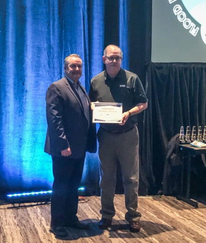
Mick Newton, AEM, PEM, CHEP, of the Noble County Emergency Management Agency, received the Excellence in Floodplain Management Award for his dedication, direction, and continued support to the Noble County Emergency Management Program.
The Excellence in Stormwater Management Award went to Adam Bowen for the Michiana Stormwater Partnership and his contributions as past chair.
The Outstanding Floodplain Project Award went to “The Whitewater River Flood Insurance Study” (Project Owner Indiana Department of Natural Resources, Division of Water; Lead Consultant HNTB Corporation). Details of the project are here.
The Outstanding Stormwater Project Award went to the “Beyer Brady Trail Stormwater Quality Project” (Project Owner City of Warsaw Engineering Department; James Emans, PE; Ryan Workman, CPESC.
April Ramoni, Executive Director of Scottsburg Advisory Plan Commission, received the Excellent Strides in Floodplain Management Award. The Chair’s Award for Outstanding Service in Support of INAFSM went to Toni Cecil, CISEC, CESSWI of the Muncie Sanitary District.
The Education and Outreach Award went to The Tippecanoe County Partnership for Water Quality (TCPWQ); Monica Christopher, Water Quality Educator & Zach Beasley, MS, PS, Tippecanoe County Surveyor
A Special Recognition Award was presented to Matt Rummel of Christopher B. Burke Engineering for his work with the conference app and other support of INAFSM.
INAFSM also recognized Jody Melton, Retired Director of the Kankakee River Basin Commission, as their newest “Lifetime Member” for his hard work and dedication over the years.
|
CTP Program Recognizes Iowa DNR and Indiana DNR for Best Practices
By Laura Algeo, National CTP Program Coordinator, FEMA - FIMA - Risk Management
In 2016, the CTP Program launched the CTP Recognition Program in an effort to recognize top performing Cooperating Technical Partners who clearly demonstrate operational best practices at any stage of a Risk MAP project and who help communities get involved in mitigation action. These are CTPs who are exceptional in the areas of project management and/or communications best practices or innovative tools and resources. The organizations who are nominated for this award are submitted by the CTP community and voted on by their peers for final selection of the first place and honorable mention winners.
This April, in our third year of the program, approximately 100 CTP stakeholders from across the country participated in a live vote to determine the top honorees. On May 23, at the ASFPM Awards luncheon, Mike Grimm, assistant administrator for risk management, announced the honorees.
First place in the 2019 CTP Recognition Program is the Iowa Department of Natural Resources (DNR) out of Region VII. The Iowa DNR is being recognized for outstanding achievement in developing CTP Communications and Outreach and Program Management activities. The Iowa DNR has enhanced traditional communications and outreach activities by embracing the use of technology to communicate flood risks. Iowa DNR developed the Draft Flood Hazard Outreach Program, which provides clarity and dialogue for the department, the community and public officials.
 |
Photo courtesy of ASFPM
The honorable mention award went to the Indiana Department of Natural Resources out of Region V for outstanding achievement in developing CTP Communications and Outreach and Program Management activities. The Indiana DNR has enhanced traditional communications and outreach activities by embracing the use of technology to communicate flood risks. Indiana DNR used funding and partnerships to merge the National Flood Hazard Layer to create the Indiana Best Available Floodplain Layer (BAFL).
Photo provided by Nicole Kim, HWC
Aside from a beautiful glass award and recognition certificates, both the Iowa and Indiana DNRs will have story maps featuring their work developed by the CERC team this fall. Thank you all for your participation in this program! We encourage you to continue to nominate your peers for next year’s program.
Article reprinted from Cooperating Technical Partners publication, “Collaboration Monthly” Volume 5, Edition 6.

Training Opportunities – 2020
(Information provided by FEMA)
Association of State Floodplain Managers (ASFPM)
ASFPM has an online training program, and training is added regularly. See http://www.floods.org/n-calendar/webinars.asp for more information.
FEMA’s Emergency Management Institute (EMI)
E0273: Managing Floodplain Development through the NFIP Dec. 2-5, 2019, May 4-7, 2020 and Aug. 31- Sept. 3, 2020, Emmitsburg, Md. This course provides an organized training opportunity for local officials responsible for administering their local floodplain management ordinance. The course will focus on the National Flood Insurance Program and concepts of floodplain management, maps and studies, ordinance administration, and the relationship between floodplain management and flood insurance.
E0278: NFIP/Community Rating System. Feb. 2-6, 2020, April 20-23, 2020 and July 27-30, 2020, Emmitsburg, Md. This course covers the Community Rating System (CRS), a nationwide initiative of FEMA’s National Flood Insurance Program (NFIP). It describes activities eligible for credit under the 2013 CRS Coordinators Manual, how a community applies, and how a community modifies an application to improve its classification.
E0282: Advanced Floodplain Management Concepts II. March 16-19, 2020, Emmitsburg, Md. This advanced floodplain management course is a dynamic and interactive instruction that covers the following four topics in detail: Placement of Manufactured Homes and Recreational Vehicles in the Floodplain, National Flood Insurance Program Flood Insurance Principles for the Floodplain Manager, Higher Standards in Floodplain Management, and Hydrology and Hydraulics for the Floodplain Manager. Each topic is designed to be discussed and reviewed in greater detail than the basic course. Developed and real-life scenarios will be examined and activities will be conducted in each section to make sure participants understand not only the rules and regulations, but also why they are in place and how to apply them in the particular topic areas. This course is activity-rich, and participants can expect to be engaged throughout.
E0284: Advanced Floodplain Management Concepts III. July 6-9, 2020 Emmitsburg, Md. This advanced floodplain management course is a dynamic and interactive instruction that covers the following five topics in detail: Floodway Standards, Disconnects between National Flood Insurance Program Regulations and Insurance, Common Noncompliance Issues, Digital Flood Insurance Rate Maps (DFIRMs), and Substantial Improvement/ Substantial Damage. Each topic is designed to be discussed and reviewed in greater detail than the basic course. Developed and real-life scenarios will be examined and activities will be conducted in each section to make sure participants understand not only the rules and regulations, but also why they are in place and how to apply them in the particular topic areas. This course is activity-rich, and participants can expect to be engaged throughout.
EMI also offers many more courses in Emmitsburg, around the country and through webinar training opportunities online. For additional information on EMI classes and webinars, please visit EMI’s training calendar website and its course catalog.
Other Trainings and Conferences
Association of State Floodplain Managers. June 7-11, 2020, Fort Worth, TX. The ASFPM annual conference is recognized as the most important floodplain conference in the United States year after year. With more than 100 speakers and more than 1,200 participants, it is the national conference all community, state and federal floodplain managers plan to attend. Please visit the ASFPM’s conference website for more information at http://www.asfpmconference.org/.
Indiana Association of Floodplain and Stormwater Managers (INAFSM): Date TBD September 2020, Evansville, IN
STATE TRAINING OPPORTUNITIES
OPERATION STAY AFLOAT 2020
Save the date! On March 18, 2020, the DNR Division of Water will host the 9th biennial Operation Stay Afloat Conference in the Conference Center at the Indiana Government Center South Building, 402 W. Washington Street, Indianapolis. Since 2004 this flood preparedness and all hazard mitigation conference has brought together floodplain and emergency managers as well as other professionals for a great day of training. This is a one-day conference you won’t want to miss. More information will be available soon or contact Doug Wagner at dwagner1@dnr.IN.gov.
CFM EXAM OFFERING – MARCH 24, 2020
Are you ready to be Indiana’s next Certified Floodplain Manager (CFM)?
The DNR Division of Water will again proctor the CFM exam on Tuesday, March 24, at the Indiana Government Center South in Indianapolis (Conference Room 14) at 1 p.m. A short instructional session will be held in the same room from 8:30 a.m. until noon the same day. You may attend the instructional session even if you do not wish to take the exam at this time but please register ahead of time so we can ensure ample space for everyone.
To take the CFM exam, you must complete and submit the CFM Program Application Package to the Association of State Floodplain Managers (ASFPM). The forms are available on the ASFPM website, floods.org, under the Certification Program tab. The fee is $100 for ASFPM members and $480 for non-members.
You may submit an application for ASFPM membership at the same time you apply to take the exam. To be accepted to take the exam at this scheduled time, you must submit your completed application and pay the appropriate fee to ASFPM by March 14. No walk-ins will be allowed unless authorized by the ASFPM executive office. For specific information on the location and times, contact Doug Wagner at dwagner1@dnr.IN.gov.
Indiana Department of Homeland Security
Please visit the Indiana Department of Homeland Security’s training calendar for upcoming courses and trainings at https://oas.dhs.in.gov/hs/training/public/calendar.do.
|
THANK YOU
Thanks to those contributing to this issue: Ryan Mueller, George Bowman, Anita Nance, Darren Pearson, Wanda Gaines, Eric Moster, Marty Benson, Don Kaczorowski, Ed Reynolds, and Laura Algeo.
Editor – Doug Wagner
The work that provides the basis for this newsletter was supported by funding under a cooperative agreement with the Federal Emergency Management Agency. The author and publisher are solely responsible for the accuracy of the statements and interpretations contained in the publication. Such interpretations do not necessarily reflect the views of the federal government.
Waterlines is produced biannually as a public service by the DNR Division of Water.
Waterlines is available on the web at dnr.IN.gov/water.

Having trouble viewing this email? View it as a Web page.
|