EAGLE MARSH AQUATIC NUISANCE SPECIES BARRIER PROJECT
By Doug Keller, Division of Fish & Wildlife
Collaboration can make good things happen when you face a challenge. The challenge of keeping Asian carp, an aquatic nuisance species, from finding a pathway to the Great Lakes, proved to be a prime example.
In fall 2015, within a span of three months, construction of a 1.7-mile-long, 7.5-foot-high berm was built for that purpose.
Getting to that point was no small feat. In order to meet all applicable federal and state regulations, the project required five years of coordinating with more than 25 individuals from more than 20 entities, as well as receiving more than 10 regulatory and local approvals, and securing $3.5 million of external funding (i.e., no state funds). Further, although 12 acres of wetland were affected by the construction, there was a net increase of 36 acres of perpetually protected wetlands that was created or restored as a result of the project.
The Project:
Eagle Marsh is a 716-acre wetland nature preserve on the southwest corner of Fort Wayne that straddles the Mississippi and Great Lakes watershed boundary. The site is jointly owned by the Little River Wetlands Project (LRWP) and the DNR Division of Nature Preserves. Natural Resources Conservation Service (NRCS) holds a Wetlands Reserve Program (WRP) easement on the site. Extensive efforts have been made since 2005 to restore former marginal flood-prone agricultural land back to wetland. This location was historically part of a 25,000-acre area once known as the Great Marsh.
At the time of settlement, the Great Marsh was said to teem with wildlife. The area, formerly referred to as the Maumee-Wabash sluiceway, was an important trade route for the Miami, French and British because it connected the most direct waterways from Quebec to French settlements in the lower Wabash, Ohio and Mississippi rivers. Efforts to drain the “swamp” began in the 1870s.
Behind the Chicago Area Waterway System, the natural watershed collection at Eagle Marsh was ranked as being a top threat where invasive Asian carp might cross from the Mississippi River basin into the Great Lakes through the Maumee. When this threat was first identified in 2010, DNR rapidly installed a fence that falls across the marsh to act as a temporary means of preventing Asian carp transfer. Plans then began to form for a permanent barrier to block Asian carp and other aquatic invasive species.
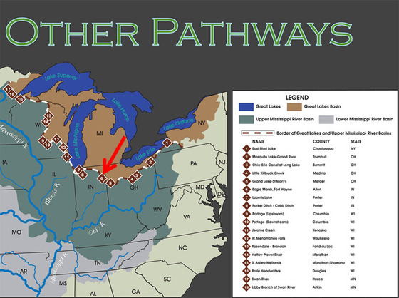
The Army Corps of Engineers produced a Great Lakes and Mississippi River Interbasin Study (GLMRIS) report for the site that presented a number of options for controlling aquatic nuisance species transfer through the area. DNR, LRWP and NRCS chose the option of an earthen berm across Eagle Marsh as the most feasible option not only to prevent aquatic invasive movement but also to achieve the goals of the wetland nature preserve.
Through close coordination between the Louisville District of the Army Corps of Engineers and the NRCS, an earthen berm was designed that would not accentuate the flooding that regularly occurs in Fort Wayne along Junk Ditch. Hydrology and hydraulics modeling by the Corps was a critical piece necessary for NRCS to design a berm that would pass all permitting requirements regarding flooding potential. As designed, the berm is nearly 9,100 feet in length (1.7 miles), ranging from 6 to 9 feet in height, and contains approximately 177,375 cubic yards of compacted fill.
With a design completed, the next hurdle was to find funding. NRCS provided more than $2.2 million for construction that would occur on the WRP easement. An additional $600,000 was provided to NRCS through the Great Lakes Restoration Initiative (GLRI) to cover construction off the WRP easement, as well as regulatory tasks, design of the mitigation area and coordination with affected utilities, local units of government, and the Norfolk Southern Railroad. Finally, another nearly $700,000 was provided to DNR from GLRI through the U.S. Fish and Wildlife Service to purchase the mitigation land, construct the mitigation site, and provide for short-term maintenance of the berm at Eagle Marsh and the mitigation property.
All three pots of money totaling $3.5 million were administered by DNR, but because they could not be combined, this created the challenge for program and fiscal managers to keep the allocations and expenditures in the appropriate spots. All money expended, including DNR personnel time, was at 100 percent federal share. No State money was used.
Before construction, numerous entities had to be consulted. Regulatory consultation involved the issuance of Army Corps 404, Indiana Department of Environmental Management (IDEM) 401, DNR Construction in a Floodway, IDEM Rule 5, and Allen County Drainage Board permits. Additional regulatory reviews included historic and archaeological review with DNR Department of Historic Preservation & Archeology (DHPA), and endangered species consultation. Coordination was required through a number of local political subdivisions that included Allen County, Allen County Parks, the City of Fort Wayne, and Fort Wayne trails. Utilities requiring consultation included Aqua Indiana, AEP/I&M Power, and NIPSCO Gas. Finally, the most troublesome permission to gain involved the berm tying in with the Norfolk Southern railroad abutment.
With everything in place, construction was expected to be completed in the 2015 season; however, the Fort Wayne area the summer of 2015 was the city’s wettest on record. The site was unworkable until mid-August, which was just a month and a half before those involved had hoped for completion. Because of the considerable delay, most partners believed the project would not be finished in the 2015 season. Instead, they hoped to get the berm to a point (high enough in elevation) at which work could easily begin again in the spring of 2016.
The unseasonably wet conditions of early summer gave way to extremely dry conditions in late summer and through much of the fall. When conditions finally allowed, the contractor and subcontractor dedicated massive amounts of equipment to move dirt. At one point it was estimated that they were moving and compacting 6,000 cubic yards of soil per day. Early in this work, due to the wet conditions, they frequently had to dedicate their largest bulldozer to pulling out equipment (haul trucks, pan scrapers, 4WD tractors, concrete truck, etc.) that was stuck.
In essentially two months (by mid-October), the major earth moving was complete. After that, two rock-fill sections were placed, a fence was built in the “overflow notch,” erosion-control matting was installed on the ditch banks along Graham-McCulloch Ditch, rye was temporarily seeded, all disturbed areas were covered with straw mulch, and the temporary barrier fence that was installed in 2010 was removed. All work was essentially completed around mid-November, except for permanent seeding that will be completed as a dormant planting, and some minor punch-list items. Getting watershed separation and “substantial completion” in just three months was an amazing feat.
During the entire berm construction project, NRCS engineering staff were on hand to assure the work was completed according to the specifications they designed. This was a tremendous commitment of time by NRCS staff.
In tandem with the Eagle Marsh berm construction, at least 20 acres of off-site wetland mitigation had to be provided in accordance with permit requirements. An interested landowner (Fort Wayne Country Club) was found less than a mile east of Eagle Marsh. The property is located along Junk Ditch in low-lying farm ground that regularly floods and is completely composed of hydric soils. A total of 38 acres of property was purchased from the country club; of that, approximately 9 acres is forested wetland, while the remainder was crop land. A private consultant was hired to design the wetland mitigation restoration that essentially involved building a low berm around the perimeter of this mitigation property to allow shallow ponding of water. A number of turtle nesting structures were also included in the plans to benefit the Blanding’s turtles and other turtles in the area.
Construction at the mitigation area began in early October and quickly progressed. Earth work was completed in a couple of weeks. Wetland seed mix was applied as a dormant season planting in the higher elevation areas, and wetland plugs were planted in the lower elevation areas in spring 2016. This mitigation property will be highly visible and will act as a valuable demonstration of wetland restoration. The property is bounded on the south and west by two major roads, and there is a heavily used biking/walking trail completely along the northern boundary. Signage has been installed as an outreach tool and to identify the property as a wetland restoration.
LRWP personnel have been a highly valued asset to the successful completion of the Eagle Marsh berm and the mitigation area. In 2010, LRWP was reluctant to have an 8-foot-high temporary barrier fence across its property because it would be a major wildlife barrier. However, LRWP fully cooperated because its staff understood the threat of invasive species and the potential devastating impacts they could have in the adjacent watershed. They were also tasked with maintaining the fence.
By 2014, when the berm planning took shape, the nine years of restoration efforts on Eagle Marsh were maturing nicely with well-established native plantings. Because of the berm construction, a large swath of these plantings were going to be destroyed. Again, LRWP understood the bigger picture of invasive species prevention and fully cooperated.
Now that the project is complete, LRWP sees great value in it because the new berm will provide an elevated trail from which visitors can more easily view wildlife, the Graham-McCulloch Ditch can be used in educational activities (the former berm did not allow access to the ditch), portions of its property are easier to access during wet conditions, and additional acres of permanent wetland pools were created as a result of the excavation for the berm. LRWP was a highly valued partner of the core team and played an integral part in the planning of the Eagle Marsh berm project and the mitigation project. In fairly short order, ownership of the mitigation property will be transferred to LRWP and a conservation easement will be placed on the property.
This project is the epitome of partnership and collaboration. Without the inputs from DNR staff from multiple divisions, federal staff from four agencies, a non-profit conservation organization, local agencies, and highly competent and motivated contractors, this project likely would not have been completed rapidly, if at all.
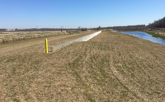 Photo by David Nance, DNR Division of Water
JUNK DITCH, A MITIGATION SUCCESS STORY IN FORT WAYNE
A heavily modified stream, Junk Ditch is on the west side of the City of Fort Wayne in the upper reaches of the western Lake Erie watershed. The ditch is about 5 miles long. From its source in wetlands and farms southwest of Fort Wayne, this highly channelized stream continues in a generally northeasterly direction through and adjacent to industrial sites and lower-density suburbs until its confluence with the St. Marys River, near downtown.
Junk Ditch is a unique watershed. Due to its position on the edge of a continental divide (Great Lakes/Gulf of Mexico) and the extremely flat topography of the area—in times of high water and when flooded with backwater from the St. Marys River—Junk Ditch actually starts to flow backward and to the west, toward the watershed of the Wabash River, a tributary of the Ohio River, and, ultimately, to the Gulf of Mexico.
As explained by Rodney Renkenberger, executive director of the Maumee River Basin Commission (MRBC), “the inefficiency of the drainage system combined with the bi-directional flow of the Junk Ditch creates a recipe for flood-damaged structures.”
After the historic flood of July 2003, MRBC began concentrating efforts to address and mitigate the problem of repeatedly flooded homes along the ditch. An earlier study by the U.S. Army Corps of Engineers determined that a permanent flood-control resolution could not be found for the area. As a result, the focus of any solution would have to be with the properties in the flood- hazard area, not the stream.
Therefore, soon after that round of flooding subsided, and working on behalf of the city, the MRBC began to prepare Flood Mitigation Assistance (FMA) and Hazard Mitigation Grant Program (HMGP) applications for the area.
As explained by Federal Emergency Management Agency (FEMA), the goal of the FMA program is to “reduce or eliminate claims under the National Flood Insurance Program (NFIP) for projects that reduce or eliminate long-term risk of flood damage to structures insured under the NFIP.” Furthermore, FMA funding “is available for flood-hazard mitigation projects, plan development, and management costs.” The HMGP provides assistance to State and local governments to carry out long-term hazard mitigation measures after a presidentially declared disaster. The program is intended to “take critical mitigation measures to reduce the risk of loss of life and property from future disasters” and ensure mitigation opportunities are taken during the rush to rebuild after a disaster.
In 2004, the first of the FMA and HMGP funding was awarded for the acquisitions in the ditch. This first round of funding in the amount of nearly $925,000 was used to purchase and remove several flood-prone structures in the watershed. It was a step in the right direction because over the next decade, the St. Marys River would again reach at least minor flood stage 15 times.
Continuing on the success of the 2004 application, between 2005 and 2008, the watershed received more than $3.5 million in additional FMA and HMGP funding that, along with a new Pre Disaster Mitigation (PDM) grant in 2014, has enabled the city, with the assistance of MRBC, to voluntarily purchase approximately 50 properties in the Junk Ditch area.
To invest a community more fully in hazard mitigation, grant funding from FMA, HMGP and other grant programs is usually a 75/25 partnership between the federal government (75 percent), the community, and sometimes the State (all others, 25 percent). In the case of Fort Wayne, the MRBC, the city, and others have contributed more than $1 million of the total cost of mitigation.
The city’s flooding problem and mitigation also extend beyond Junk Ditch. Within the city as a whole, between 1982 and 2009, more than 160 flood-prone homes have been purchased by the city and the MRBC. Of the homes purchased, approximately 80 have been in the St. Marys River floodplain, and an additional 15 or so others have been in various other locations across the city. Seventeen additional homes are in the pipeline for such purchase.
After purchase, using grant funding, the properties are cleared of the structure and the land is deeded as permanent open green space to limit potential future damage. At this point the property may now serve as an area that floodwater may envelope or be stored in without burden to the community.
“This flood mitigation project is an example of how the Maumee River Basin Commission assists communities with permanent non-structural flood damage reduction solutions. Non structural projects allow emergency services personnel to be deployed to areas of greater risk because they are no longer needed in the project area,” Renkenberger said. That is, when there are no longer homes to defend or citizens to rescue from floodwaters, the already-limited resources available in an emergency can be placed elsewhere within the city.
“We have a ways to go, but as demonstrated, we remain committed to completing the task of mitigating all flood-damage potential in this area,” Renkenberger said.
Additional information on the HMGP, FMA, and PDM programs can be found at on FEMA’s website at:
http://www.fema.gov/flood-mitigation-assistance-grant-program
www.fema.gov/hazard-mitigation-grant-program
http://www.fema.gov/pre-disaster-mitigation-grant-program
In addition, flyers for each program may be downloaded at:
HMGP - www.fema.gov/media-library/assets/documents/16091.
FMA - http://www.fema.gov/media-library/assets/documents/106315
 DAM DANGEROUS – PICTURESQUE YET DECEPTIVELY DEADLY DAMS
By Manuela Johnson, Indiana Department of Homeland Security
Indiana has more than 150 dams located in a variety of rivers and streams. Although the dams may look like waterfalls and beckon water recreation enthusiasts, they hide a powerful force. In-channel or low-head dams have a feature known as a keeper hydraulic that forms at the dams’ base as the water plunges over the upper edge to the streambed below. When the water hits the streambed, it flows upward and curves back to the face of the dam. Circulating much like a frontload washer, the keeper hydraulic entrains so much air that a person cannot effectively paddle or swim out. Their buoyancy changes so that they are easily recirculated with the water to the bottom of the stream, then up to the top, and pushed against the face of the dam then back to the bottom.
These dams not only are hazardous to human life, but also restrict the free movement of fish and other water life from migrating upstream.
In 2015, the Indiana Silver Jackets assembled a multi-agency team to address the issue. The team has been working to establish a record of all the people who have been affected by the dams—killed, injured, and/or rescued. The average age of those killed is 20.5. Seventy-five percent of the people killed were participating in a recreational activity in or on the water. The other 25 percent who died were trying to help a person in need. This year alone there have been more than 20 deaths, nationwide, at such dams.
The Silver Jackets are cataloguing all of the in-channel/low-head structures in Indiana with help from DNR Law Enforcement and county surveyors, who are confirming and documenting the structures. A GIS map will soon be available so the public can learn where the dams are. The team has also worked with the public information officers (PIOs) from three agencies (DNR Law Enforcement, Indiana Department of Homeland Security, and Department of Child Services) to remind Hoosiers about water safety in general and, specifically, at and near dams. Furthermore, the team will run a social media campaign to share little known facts with the public. Team members from various agencies were given an opportunity to participate in a one-day swift-water safety course in early June at the East Race of the St. Joseph River in South Bend. This program allowed staff to recognize the power of the water as well as learn self-rescue techniques and methods to assist someone who may need assistance.
There are six principles to keep in mind when you are near the water.
1) ALWAYS WEAR your personal floatation device (PFD) when participating in recreational activities on or near the water.
2) Plan your water event—tell someone where you are going and when you intend to return.
3) Be aware of the weather both on the day of your activities and up to a week before. Rains upstream can result in high water and high velocities that can form strong keeper hydraulics.
4) Know the river or stream. Be aware of where there are dams.
5) Keep your distance from in-channel/low-head dams both up and downstream.
6) If you end up in the water, forget about personal possessions like cellphones, keys, etc. They can always be replaced. You can’t. Save yourself.
|
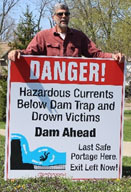 IUPUI Senior School of Journalism students produced an outreach plan, created the Twitter hashtag #DamDangerous, and the logo for their senior capstone project. In addition, the Silver Jackets low-head dam subcommittee designed a template sign for communities. The City of Fort Wayne was the first to install signs, with 37 placed both up and downstream of the three dams on its rivers. This fall, WFYI and other PBS affiliates in the state will air a 30-minute documentary on in-channel/low-head dams. Check it out. You may recognize a star or two.
|
PROMOTIONS IN THE FLOODPLAIN MANAGEMENT SECTION
In February, Anita Nance was promoted to the position of National Flood Insurance Program (NFIP) state coordinator. She has worked in the Floodplain Management Section since 1997 and is well acquainted with the program, Indiana’s communities, and floodplain management. She has been a Certified Floodplain Manager (CFM) since 2000. She leaves the position of senior planner.
Darren Pearson was promoted to senior planner in April. He has worked for the Floodplain Management Section since 2001. He became a CFM in 2015. He leaves the planner 2 position, which was responsible for the southern portion of the state. His knowledge will serve him well as he gains more responsibility for training and outreach.
 |
 INDIANA’S NEWEST CFMS
On March 29, Indiana gained three more Certified Floodplain Managers (CFMs). Congratulations to Michael Ellis (Wessler Engineering), Mandy Woods (Huntington), and Jon Eggen (DNR). Each earned this designation when they passed the national exam.
This national program for professional certification of floodplain managers was established by the Association of State Floodplain Managers. The program recognizes continuing education and professional development that enhance the knowledge and performance of local, state, federal and private-sector floodplain managers.
It’s obvious that the CFM certification is becoming more recognized and more desired. Many companies indicate a preference for applicants with the CFM certification. Others desire their employees to gain this certification. At each offering, we see a few more take the exam.
|
 20TH ANNIVERSARY CONFERENCE
The Indiana Association for Floodplain and Stormwater Management will have its 20th Anniversary Celebration Conference, Sept. 7-9, at the Belterra Conference Center along the banks of the Ohio River in Florence, in beautiful southeast Indiana.
There is a full agenda planned, including a new “technical track.” In addition to plenary sessions, conference attendees will have floodplain, stormwater, MS4, and the new technical track topics from which to choose.
For more information on the conference, or to register, visit www.inafsm.net.
|
TRAINING OPPORTUNITY – FEMA L-273 COURSE
FEMA is once again state-deploying course “L-273 Managing Floodplain Development through the National Flood Insurance Program (NFIP)” in Indiana. FEMA Region V (Chicago) staff will conduct the in-depth training course with assistance from the DNR Division of Water.
This course is designed to provide an organized training opportunity for local officials responsible for administering their local floodplain ordinance. The course will focus on the NFIP and concepts of floodplain management, maps and studies, ordinance administration, and the relationship between floodplain management and flood insurance. Hands-on exercises are included to allow participants to better apply the information in their communities.
If you are involved with floodplain issues in your community, this training is immensely valuable. It will provide thorough training on the basics of the NFIP. If you are looking to become a Certified Floodplain Manager (CFM), this course is exceptional preparation. If you are already a CFM, you can earn continuing education credits by completing this course.
The course is held four consecutive days, Aug. 9-12. Hours will be from 8:30 a.m. to 5 p.m. each day. To obtain credit and receive a certificate of completion, attendees will be expected to be present for the entire four days.
The course will be held at the Conference Center (Conference Room 18) in the Indiana Government South Building, 402 W. Washington Street, Indianapolis.
There are no registration fees; however, space is limited. No lodging, meals, snacks or parking will be provided.
This course has a prerequisite that must be completed online before the course begins. To take the L-273 course, contact Anita Nance, NFIP state coordinator, at anance@dnr.IN.gov or (317) 234-1110, no later than July 26, for an application, more information about the prerequisite, and other details.
REFRESHER COURSE AND EXAM OFFERED AT INAFSM CONFERENCE
Have you considered becoming a Certified Floodplain Manager? Many companies and communities prefer applicants who have “CFM” behind their name when they have an open position that involves floodplain issues. Being certified indicates that an individual has a good base knowledge of floodplain management. The Association of State Floodplain Managers (ASFPM) has established this national program for certifying floodplain managers. The program recognizes continuing education and professional development that enhances the knowledge and performance of local, state, federal and private-sector floodplain management professionals.
Because INAFSM is a State Chapter, it routinely offers the CFM exam at the annual conference. This year the conference is Sept. 7-9. A three-hour refresher course covering a wide variety of floodplain topics will be available at the conference for those taking the exam and those who may wish to take it in the future. Anyone is welcome. Check the agenda for times and locations on INAFSM’s website, inafsm.net.
To take the exam at the upcoming conference, you must apply at least two weeks before the conference starts, through the ASFPM website, www.floods.org. Make sure you complete the application and receive an email confirmation from ASFPM. No walk-ins will be allowed.
THANK YOU to contributors to this issue: Rodney Renkenberger, Manuela Johnson, Doug Keller, Debbie Smith, Marty Benson, Don Kaczorowski, and Ed Reynolds.
Editor – Anita Nance
The work that provides the basis for this newsletter was supported by funding under a cooperative agreement with the Federal Emergency Management Agency (FEMA). The author and publisher are solely responsible for the accuracy of the statements and interpretations contained in the publication. Such interpretations do not necessarily reflect the views of the federal government.
Waterlines is produced biannually as a public service by the DNR Division of Water
Waterlines is available on the Web at www.IN.gov/dnr/water
Having trouble viewing this email? View it as a Web page.
|