|
The Federal Emergency Management Agency (FEMA) will be hosting an open house on Wednesday, December 4, at Nippersink Public Library in Richmond, IL, from 3 to 6 p.m. to present the preliminary flood maps for portions of the Nippersink Creek Watershed and answer questions. Experts from FEMA will provide updated flood maps and information about your flood risk.
All are invited. Homeowners, renters, and business owners are encouraged to attend and meet with experts one-on-one to check their own addresses on the new maps.
Attendees who require accommodations, such as sign language interpreters, can request assistance by emailing FEMA at least 48 hours before the open house.
If you cannot attend the open house, contact FEMA Flood Mapping and Insurance EXchange (FMIX) at 877-336-2627, via email, or via chat. A map specialist can help answer your questions.
Key Points for Nippersink Creek Watershed:
Overview
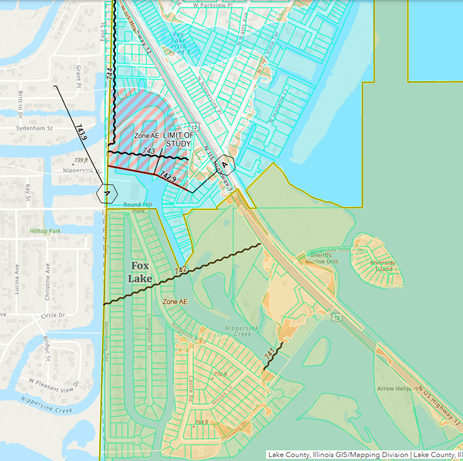
Over the past 10 years, FEMA has been working to update our local flood risk information, including a revised Flood Insurance Rate Map (FIRM) indicating the areas of our communities most vulnerable to flood risk. Twenty streams were studied as part of the Nippersink Creek Watershed project. The recently released preliminary maps represent a more comprehensive, collaborative re-examination of the local flood zones.
Flood risks change over time due to changes in land use, development, or other factors. It’s important for the information available in our community to reflect the changes so that we can rely on it to identify actions we can take to protect our community from future risk. The outcome of this multiyear process will be more up-to-date, digital information that helps us understand our community’s current flood risk and protect the places we love from the damage of future floods, including public spaces, businesses, and properties. At the upcoming Open House, FEMA’s partners will be available to discuss the new flood hazard map released in late August 2024. These experts can explain what this means for our community and your property and will answer questions.
About the Risk Mapping, Assessment, And Planning (Risk MAP) Effort
Risk MAP is a nationwide effort designed to provide communities like ours with more precise flood hazard maps, risk assessment tools, planning, and outreach support to enhance our local mitigation plans and strengthen our ability to make informed decisions about reducing flood risk.
Benefits of Map Updates
Flooding can be dangerous and costly. The new maps will provide a more complete picture of the risk that affects our community so we can take action to address it. For example, builders and developers can use the updated map data to determine where and how to build structures more safely to protect them from flood damage. Real estate agents will be better equipped to inform clients of any factors that may affect properties and make them aware of upcoming changes in flood risk status and flood insurance requirements.
Upcoming Milestones
The 90-day Public Appeal Period is estimated to begin Spring 2025. During the official 90-day appeal period, members of our community, including homeowners, landowners, business owners, and lessees can submit appeals and comments based on scientific and/or technical data that would justify revising the preliminary Flood Insurance Study (FIS) report and flood map.
It is anticipated that the updated maps will take effective in Fall 2026. Note, the timeline is subject to change depending on appeals received.
For More Information
- Visit https://www.illinoisfloodmaps.org/, to learn more about this project. At this site, you can download the preliminary maps to see what areas of the Nippersink Creek Watershed will change and listen to previous meeting recordings.
- Visit floodsmart.gov to see an overview of the National Flood Insurance Program, how to purchase a flood insurance policy, and how to find a flood insurance agent in the area.
- Visit this link for more Floodplain information for Lake County.
|