|
Even though no additional precipitation is forecast for Lake County in the foreseeable future, the Lake County Stormwater Management Commission is maintaining red flood status, meaning major flooding is continuing. It’s important to realize that the rivers still haven’t crested and additional flooding is imminent.
 Fox River/Chain O’ Lakes:
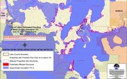
The Fox River is predicted to rise approximately two additional feet. Please view the inundation maps which show a prediction of additional structures that will be impacted. View MAPS.
The inundation maps are a helpful tool in predicting where additional flooding MAY occur. These maps are generated using data from previous floods, and current modeling based on the amount of water and rate of flow. We want to share these with the public to help increase awareness of the flooding situation.
Disclaimer: Inundated areas shown should not be used for navigation, regulatory, permitting, or other legal purposes. Lake County provides these maps “as-is” for a quick reference, emergency planning tool but assumes no legal liability or responsibility resulting from the use of this information. Although the flood-inundation maps represent the boundaries of inundated areas with a distinct line, some uncertainty is associated with these maps and may change.
Inundation maps are not currently available for the Des Plaines River as the river is nearing crest levels. We will continue to monitor the Des Plaines River through the weekend.
Watch for updates on Lake County's Facebook page. We will be posting information as the situation develops.
|
|