IDL tracks and monitors news coverage of our activities and significant events that may impact our operations, recapping the coverage in this newsletter.
This publication also details IDL's social media posts for the week, keeping stakeholders and our front-line customer service staff apprised of our public-facing communications.
It all starts in the spring as fire officials from the state, federal and tribal lands get together to review the plan. As fire season starts in the beginning of May managers in each district meet once a week to assess the criteria in their zone.
Stage 1 fire restrictions in force in North Central Idaho
Idaho County Free Press, 7-24-24
Activity restrictions are now in place within the region due to increased fire danger.
Hot and dry weather conditions have recently continued to cure both live and dead fuels across the landscape in North Central Idaho, prompting a decision amongst interagency land managers to implement fire restrictions for the Grangeville Fire Restrictions Area.
As of Saturday, July 20, fire wardens and fire management officers from the Nez Perce Tribe, Idaho Department of Lands, Bureau of Land Management, Clearwater-Potlatch Timber Protection Association, and the Forest Service collectively implemented Stage 1 Fire Restrictions for the Grangeville Fire Restrictions Area — these apply to all federal, state and endowment, private forestlands, and rangelands within the designated area.
SALMON, Idaho — Due to weather and fuel conditions, the Central Idaho Dispatch Zone has become an area of extreme fire danger.
According to the U.S. Forest Service, small fires can quickly become large in extreme fire danger and exhibit extreme fire intensity, such as long-distance spotting and fire whirls. These fires can be challenging to control and will often become much more significant and longer-lasting.
The Forest Service cautions campers, hikers or travelers to #KnowBeforeYouGo. The Central Idaho Fire Restrictions Area is in stage one fire restrictions and encompasses portions of Custer County north and east of the Sawtooth National Recreation Area (excluding the Frank Church River of No Return Wilderness) and the portion of Lemhi County that is not federal land designated as wilderness. Stage one fire restrictions apply to campfires and smoking.
Stage one fire restrictions ordered for McCall as wildfire conditions persist
KIVI, 7-22-24
MCCALL — As wildfire conditions persist in Idaho, land management agencies in the Payette Fire Restrictions Area are preparing to implement stage one fire restrictions on Friday, July 26 with plans to keep the restrictions in effect until October 1, 2024.
The area covered by the order includes the Payette National Forest (excluding the Frank Church River of No Return Wilderness), Idaho State Endowment Lands, the BLM Cottonwood Field Office, and other private lands in central Idaho.
The fire restrictions aim to decrease the risk of human caused wildfires in the listed areas. With high potential for wildfires, fire managers are asking those in Idaho to be cautious when spending time outdoors.
As weather experts forecast above normal temperatures nationwide this summer, the risk of wildfires will rise across the country, including in Idaho.
Officials with the Bureau of Land Management and the Idaho Department of Lands gave a fire forecast briefing to the Idaho State Board of Land Commissioners in mid-June. BLM meteorologist Jim Wallmann told the land board that the area of Idaho near Salmon and southern parts of the Idaho Panhandle are the most vulnerable to wildfire this summer.
While much of the southern part of Idaho had a wet winter and steady snowpack, Wallmann said low snowpack and dry summer conditions put central and northern areas at higher wildfire risk.
Burn bans and restrictions in effect across southern Idaho
KIVI, 7-20-24
As wildfires continue to pop up across Idaho and the U.S., it's important they everyone be aware of the burn bans and restrictions currently in effect in their area.
Southern Idaho has several burn bans in place as of July, including Ada County, Canyon County, Owyhee County and Payette County. All outdoor burning is prohibited in counties with burn bans.
...
According to Idaho Department of Lands, individuals living outside city limits anywhere in Idaho who plan to burn for any reason — including crop residue burning and excluding recreational campfires — from May 10 to October 20, must obtain a fire safety burn permit.
Celebrate Smokey Bear’s 80th birthday at the McCall Smokejumper Base
News From the States, 7-20-24
The Payette National Forest invites the public to celebrate Smokey Bear’s 80th birthday from 11 a.m. to 2 p.m. July 28 at the McCall Smokejumper Base’s south lawn at 605 N. Mission St. Parking will be available at the Riverfront Park large gravel lot below Mission Street.
Smokey Bear has been an icon in promoting forest fire safety with his tagline “only you can prevent wildfires.” This celebration is to honor his legacy as the face of America’s longest-running public service campaign for over eight decades, according to a press release from Payette National Forest.
Activities include:
Children touring fire engines and playing “pin the bucket and shovel on the campfire”
Singing “Happy Birthday” to Smokey Bear
A local library reading “The True Story of Smokey Bear”
Raffles with Smokey Bear Prizes
Various fire organizations collaborating to promote fire safety
The event is a collaboration with the McCall Fire Department, Valley County Fire Wise, Southern Idaho Timber Protective Association, Idaho Department of Lands, the Wildland Firefighter Foundation and the Donnelly Library.
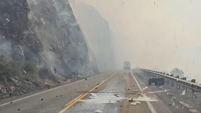
People Flee Idaho Town Through a Tunnel of Fire and Smoke as Western Wildfires Spread
US News & World Report, 7-26-24
Lightning strikes have sparked fast-moving wildfires in Idaho, prompting the evacuation of multiple communities, including one where a man drove past a building and trees engulfed in flames as a tunnel of smoke rose over the roadway.
Videos posted to social media include a man who said he heard explosions as he fled Juliaetta, about 27 miles (43 kilometers) southeast of the University of Idaho's campus in Moscow. The town of just over 600 residents was evacuated Thursday just ahead of the Gwen Fire, as were several other communities near the Clearwater River.
The Idaho Department of Lands said “multiple structures” were burned, but the agency did not immediately release additional details, including whether the structures were homes or outbuildings.
Wind Driven Wildfires Spread Quickly East of Lewiston
Big Country News, 7-26-24
Photo: Nate Donner
LEWISTON - After lightning moved through the area on Wednesday, multiple fires have quickly spread in the region. Most of the fire activity is located to the east of Lewiston.
Multiple structures were lost as wind fanned the flames throughout the day on Thursday. The entire town of Juliaetta and surrounding areas were placed under a Level 3 (go now) evacuation notice. Highway 3 and Highway 12 are both shut down in the area. As of 6:00 a.m. Friday, the highways were still closed.
The Idaho Department of Lands says an "all-hands on deck wildfire response" was implemented as the heat of the day and wind pushed the fire. A Complex Incident Management Team was ordered to the fire scene on Thursday.
Entire town of Juliaetta told to evacuate for wildfire
KXLY, 7-25-24
JULIAETTA, Idaho —
UPDATE, 10 p.m. on July 25:
According to Latah County Sheriff's Office, Level 3 (Go Now) evacuations are still in effect for the entire town of Juliaetta as of 10 p.m. on Thursday, due to the Gwen Wildfire burning about 30 miles outside of Lewiston.
Level 2 (Get Set) evacuations have been expanded to include the area west of Highway 99, up to Bethel Road (see yellow area on below map.) Anyone in this area should be ready to leave at a moment's notice.
As of 10 p.m. on Thursday, the city of Kendrick is not in the Level 2 (Get Set) evacuation zone.
4,000 acres in Juliaetta-Myrtle area; 'go now' evacuation orders issued for that area
Moscow-Pullman Daily News, 7-25-24
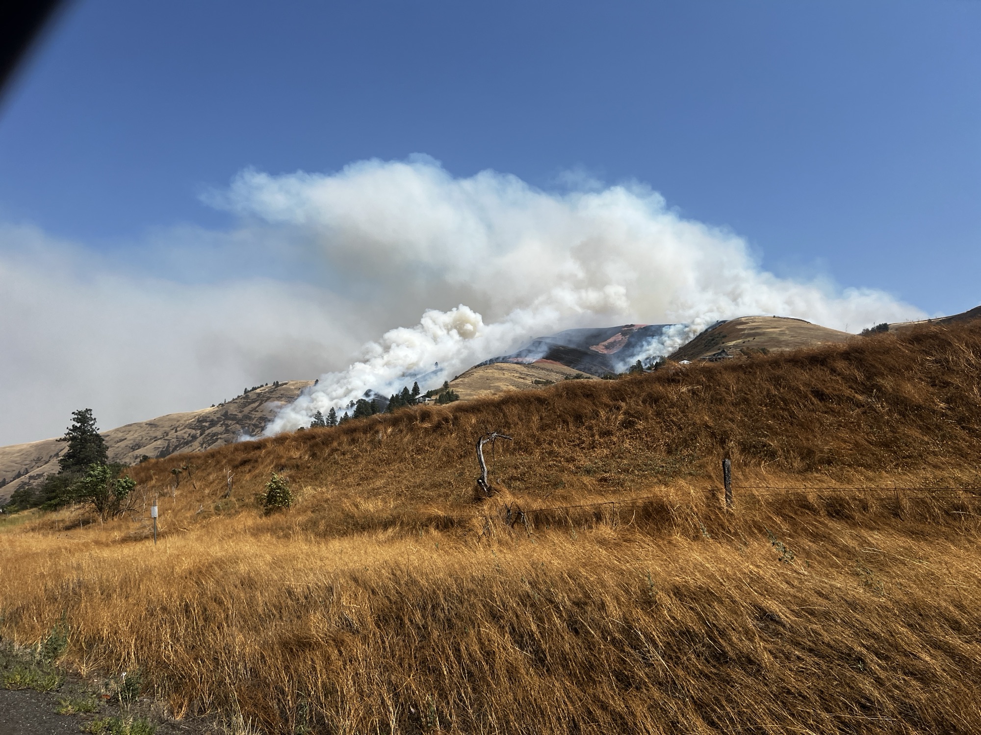
A hillside along the banks for the Clearwater River smolders Thursday afternoon. The Gwen Fire has burned 2,000 acres, according to the Idaho Department of Lands.
August Frank/:Lewiston Tribune
RELEASED AT ABOUT 4 P.M. THURSDAY: This map shows the area under evacuation orders because of the Gwen Fire in the Juliaetta area.
UPDATE AT 6:01 P.M.:
The communities of Juliaetta, Myrtle and the Cherrylane area, as well as the surrounding area, are under Level 3 evacuation orders, meaning "go now," because of two fires that ripped through the area Thursday afternoon.
The Gwen Fire and the River Fire have each burned about 2,000 acres, according to an update from the Idaho Department of Lands at about 5:45 p.m. Thursday.
Structures have been lost, according to the IDL update. No other details were provided.
Gwen and River Wildfires prompt evacuations, highway closures
KIVI, 7-25-24
UPDATE(July 25, 9:44 pm): The Gwen and River fires are being measured at 2,000 acres each, prompting closures and evacuations.
The Idaho Transportation Department is alerting drivers in the area to a major closure on SH-3 from SH-3 Southbound to McGary Grade. All lanes are closed.
In the same area, another major closure on US-12 is stopping traffic in both directions from US-95 to Big Canyon Rd.
The Latah County Sheriff's Office has released a map with updated evacuation levels (below) for the surrounding cities.
Urgent Evacuation Orders Issued for Gwen Fire near Juliaetta and Arrow Junction
Big Country News, 7-25-24
Firefighting Efforts: The Nez Perce Tribe, Idaho Department of Lands, Forest Service, area rural fire departments, and local landowners are assisting in battling the fire. A single helicopter has been deployed to aid in the firefighting efforts.
Update at 1:50 p.m. Thursday Afternoon:
Evacuation Orders: The situation has escalated, and the following areas are now under Level 3 "GO NOW" evacuation orders:
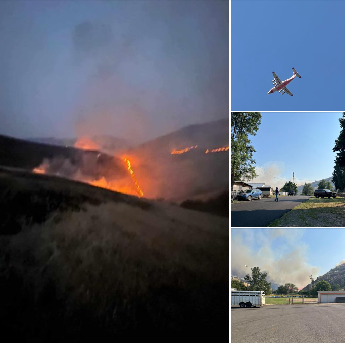
Gwen Fire Official Update, With Photos
DailyFly, July 25, 2024
GWEN FIRE INITIAL REPORTS
Acres: 2000
Initial Dispatch Report: July 24
Location: South of Juliaetta Idaho, about 30 miles outside Lewiston near State Highway 3 in Latah County, Idaho near Clearwater River
Jurisdiction: Nez Perce Reservation, threatening Idaho Department of Lands Forest/Fire Protection areas
Resources/Agencies include: The Nez Perce Tribe, Idaho Department of Lands, area rural fire departments, local landowners
***A second fire, The River Fire, was also reported today, and is located on the east end of Arrow Highline Road, west of the town of Myrtle in Latah County along the Clearwater River. Last acreage reported was 2000 acres***
North central Idaho’s Texas Fire is 80% contained, fire officials say in last planned update
Idaho Capital Sun, 7-24-24
Crew members from the Miller Timber Services, Alpha Crew, grid the Texas Fire as part of mop-up operations outside of Kendrick, Idaho on July 22, 2024. (Courtesy of SRouse, public information for the Northern Rockies Team 8)
Fire officials plan to assign fewer firefighters to the Texas Fire in north central Idaho as they report the wildfire is 80% contained.
The Texas Fire burning east of Kendrick in Latah County slightly grew to 1,582 acres, the Idaho Department of Lands said in a news release Wednesday, which is the final update on the fire unless conditions change.
Early Thursday, the Idaho Department of Lands is set to take over commanding the Texas Fire from the Northern Rockies Team 8, the release said. Type 4 Incident Commander Robbie Easley is set to command the fire along with about 50 firefighters.
Idaho Department Of Lands Sends Out FINAL Update For Texas Fire
DailyFly, 7-24-24
Location: East of Kendrick, Idaho
Cause: Human
Size: 1,582 acres Containment: 80% Personnel: 114
Northern Rockies Team 8 will transfer command of the Texas Fire back to the Idaho Department of Lands Thursday, July 25th at 6:00 AM PT. Robbie Easley, a local Type 4 Incident Commander will assume command of the fire along with approximately 50 firefighters.
Current Situation:
Approximately 50 firefighters, including 2 crews, 2 engines, and 1 water tender will remain on the incident and continue to patrol the fire area. Firefighters will check on visible smokes and take necessary actions to stop further fire spread.
KENDRICK - Crews continue to make progress in battling the Texas Fire, located east of Kendrick on the Latah/Nez Perce County line.
As of Tuesday evening, the fire's total footprint remained at 1,582 acres and containment was listed at 80%.
Firefighters have reportedly completed initial mop-up around the entire fire perimeter on Monday, including the eastern spot fire, working 100 feet into the black from the fireline.
Containment on the 1,582-acre Texas Fire east of Kendrick grew to 80% as of Tuesday, according to a news release from Northern Rockies Incident Management Team 8.
Firefighters completed an initial mop-up of the fire perimeter on Monday and planned to monitor the blaze Tuesday and take care of hot spots. Many of the 114 people working on the fire will be deployed over the next few days.
The fire is listed as human-caused, but fire officials and law enforcement have not yet identified exactly how it started.
Progress Continues on Texas Fire Near Kendrick, now 70% Contained
Big Country News, 7-23-24
KENDRICK - Crews continue to make progress in battling the Texas Fire, located east of Kendrick on the Latah/Nez Perce County line.
As of 5:00 p.m. on Monday, the fire's total footprint remained at 1,565 acres and containment was listed at 70%.
Firefighters have reportedly completed initial mop-up around the entire fire perimeter on Monday, including the eastern spot fire, working 100 feet into the black from the fireline. Due to extended hot and dry conditions, many portions of the fireline are supported by water systems consisting of hose lays, pumps, and sprinklers maintained by fire personnel.
Texas Fire in North Idaho is now 60% contained, officials say
Idaho Capital Sun, 7-22-24
Crews fighting the Texas Fire burning east of Kendrick in Latah County report that the fire is 60% contained, making “significant progress” securing the fireline, fire officials said.
Almost 200 firefighters were fighting the human-caused fire in North Idaho that has shrunk to 1,565 acres with more accurate mapping, according to a news release Monday morning from Northern Rockies Incident Management Team 8.
The fire started July 15.
Firefighters on Monday were set to reinforce the fireline, and would address smoke and heat areas as needed, the news release said. Crews were continuing to remove brushy fuels and installing more hose lays to extinguish remaining heat where possible, the release said.
Containment of Texas Fire Near Kendrick Jumps to 60%
Big Country News, 7-22-24
KENDRICK - Crews continue to battle the Texas Fire, located east of Kendrick on the Latah/Nez Perce County line.
According to a Sunday evening update from officials, the fire's total footprint was estimated at 1,575 acres. The blaze is now considered 60% contained. The fire area grew by only 32 acres between Thursday and Saturday. No growth was reported between Saturday morning and Monday morning.
On Saturday morning, all evacuation orders were lifted and all roads were reopened in the region.
200 firefighting personnel help contain Texas Fire near Kendrick
Fox28, 7-21-24
KENDRICK, Idaho – The Texas Fire that began last Monday has burned about 1,600 acres, has drawn nearly 200 emergency response personnel and is 20% contained as of Saturday.
“As members of the public begin returning to their properties, we urge them to be mindful of the firefighters that are continuing to work and drive within the fire area, for your safety and theirs,” DOL said.
Texas Ridge Fire at 20% containment, minimal fire activity expected
Moscow-Pullman Daily News, 7-21-24
he Texas Ridge Fire east of Kendrick is now 20% contained as crews have made lines around the fire.
The fire is at 1,575 acres, which is the same that was reported Saturday. Crews secured a control line around the fire Saturday and then went into the fire with water from engines, water bags with hand pumps and installing hoses and sprinkler systems. Helicopters dropped buckets to cool down areas with brushy fuels to allow firefighters to safely mop up the area, according to a news release from the Idaho Department of Lands.
Fire activity is expected to remain minimal with some creeping fire and smoldering, but little to no open flames. Firefighters will continue to look for and extinguish remaining heat and smoke within 100 feet of the fire perimeter, according to the news release.
Evacuations have been lifted for the Texas Ridge Fire burning east of the Kendrick.
The Latah County Sheriff’s Office posted on its Facebook page that at 9:38 a.m. Saturday evacuations had been lifted and the roads were reopened.
On Friday, Level 1 and Level 2 evacuation zones for residents near Kendrick were lifted and Level 3 evacuations had still been in place for the Cedar Creek Canyon area.
The Texas Fire began July 15 and has burned 1,575 acres east of Kendrick.
Containment of the fire is at 10%, which is the same as reported Friday. But fire activity was minimal with little open flames throughout the day.
200 firefighting personnel help contain Texas Fire near Kendrick
KHQ, 7-21-24
KENDRICK, Idaho – The Texas Fire that began last Monday has burned about 1,600 acres, has drawn nearly 200 emergency response personnel was 60% contained as of Sunday evening.
“As members of the public begin returning to their properties, we urge them to be mindful of the firefighters that are continuing to work and drive within the fire area, for your safety and theirs,” DOL said.
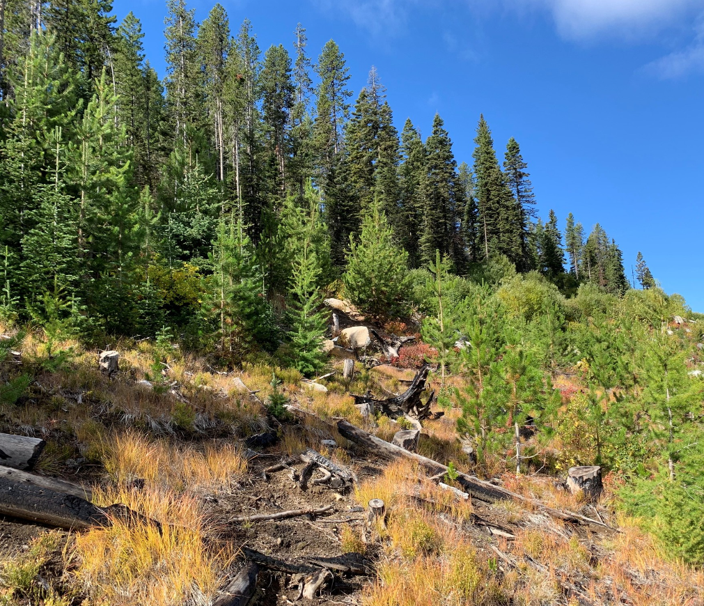
Healthy forests are at a lower risk of wildfires. Our sustainable management practices at the Idaho Department of Lands ensure that our forests remain strong and resilient while the trees grow, providing safety for both our landscapes and wildland firefighters.