|
FOR IMMEDIATE RELEASE
June 12, 2018
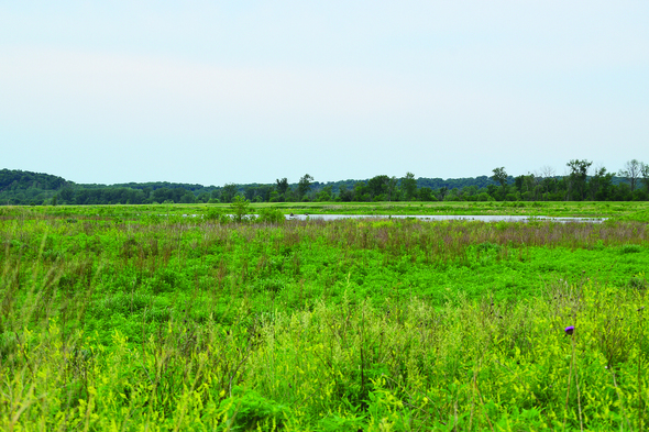 Noddleman Island is a quick drive south of Council Bluffs within eyeshot of I-29. It’s home to a network of potholes for kayakers and marsh bird enthusiasts and plenty of space for hiking and hunting. Visitors can see native plants like false indigo bush, Canada anemone, wild strawberries, wild grapes, cord grass and more. Photo courtesy of the Iowa DNR.
The old advertising tag line – just waiting to be explored – could have
been written for Noddleman Island Wildlife Management Area on the east shore of
the Missouri River.
The nearly 1,300 acres of public Iowa
wildland sits just a stone’s throw west of I-29, a few miles southwest of
Glenwood and less than 30 minutes from Council Bluffs and Omaha. It offers the
curious an opportunity at seeing some unique Iowa birds, hike a floodplain,
hunt with little competition and experience an ecosystem in the process of
being restored.
Noddleman Island has two distinct
personalities – one is mild, the other is not.
The mild is mild– a network of
potholes next to the access lane within eyeshot of I-29 provides a quick trip
for kayakers, marsh bird enthusiasts and duck hunters. The non-mild requires
hunters, bird watchers or explorers to hike in carrying their gear, navigating
a drainage ditch that is usually flowing with water just to get to the island
part of the area.
But once on the island, it’s likely to
be a solitary experience, except for the resident wildlife - quail, pheasants,
deer, waterfowl and more.
“If you’re willing to hike, you’ll
likely have the area to yourself and see some pretty cool stuff,” said Lindsey
Barney, district forester for the Iowa Department of Natural Resources.
Visitors can see native plants like false
indigo bush, Canada anemone, wild strawberries, wild grapes, cord grass and
more. And that’s just in the mild zone. Imagine what can be found in the non-mild.
Barney is overseeing the reforestation
effort underway on 70 acres of lowlands damaged by the 2011 flood. As part of
her management plan, she has been referencing survey maps created in 1875 that indicate
a large floodplain forest was once here.
Nearly 43,000 bottomland hardwood
trees were planted four years ago and the growth is evident with the sycamores
leading the way. In addition to the sycamores, the primary planting included cottonwoods,
willows and silver maple, but Barney added a few walnut, pecan, American plum,
green ash and dogwood. All of the stock came from the State Forest Nursery.
While planting 43,000 trees on 70
acres seems like a lot, naturally seeded young floodplain forests have several
thousand trees per acre, and in the end, nature will determine the survivors.
“We’re missing some substantial timber
down here,” she said. “Anything we can get back, I’m excited about.”
Standing in the middle of an emerging
bottomland hardwood timber stand, the sounds of pheasants, quail, ducks and
geese are joined by redwing blackbirds and dickcissels. Dragonflies, bumble
bees and butterflies move through the area with a sense of purpose. There is
little evidence that anyone has been here recently.
Watching
for invaders
The flood of 2011 is still causing
damage years after its water retreated.
Japanese hops appeared after the flood
and has been smothering everything in the floodplain. The exotic invasive can
grow up small trees or shrubs and on top of grasses.
“When it grows on everything, treatments
must be limited to avoid injuring desirable native plants,” Barney said. “It
doesn’t green up early or stay green late like other invasives. The only
natural way to suppress it is through shade. That’s why it’s a problem in floodplains.
Large cottonwoods die off from flood damage, and the shade is gone.”
Another invader has been around for
years.
The tree of heaven. Don’t be misled by the name.
“It’s the worst of the worst,” Barney
said. “It’s the ‘checkmate’ for an upland forest. You can have one of those
trees in your upland forest and if you miss it and perform routine thinning
work, in 10 years, you will be overrun with it. Disturbed ground is its perfect
habitat.”
Tree of heaven was brought in from
China in the 1800s because it could grow in difficult soils, which made it a
good ornamental tree.
It blends in with natives and has
features that are similar to a variety of trees and looks nearly identical to
the Kentucky coffee tree. It becomes seed producing at age five or six, and can
produce 300,000 seeds each. Each seed can have up to a 90 percent germination
rate.
Traditional woody plant control
treatments don’t work and, in fact, could make things worse.
So far, tree of heaven has not been
found at Nottleman Island. Japanese hops was found, but it was spot treated in
the planting unit prior to planting.
Media Contact: Lindsey Barney, District Forester,
Iowa Department of Natural Resources, 712-482-6245 or Pete Hildreth, Southwest
Iowa Wildlife District Supervisor, Iowa Department of Natural Resources,
712-254-0955.
The Maquoketa River Water Trail, in Delaware County, will be dedicated
as Iowa’s newest official water trail during a public ceremony at noon on June
16, at the gazebo next to the whitewater park, in downtown Manchester.
Covering 18 river miles, the Maquoketa River Water Trail begins at
Backbone State Park, Iowa’s first state park, and ends at Bailey’s Ford Access.
It’s
the first water trail that includes a whitewater park and a large area of
restored river above the Quaker Mill area.
The Maquoketa River Water Trail showcases limestone cliffs, mature
oak forests, lowland forests and diverse wildlife. Some stretches provide a quiet, prehistoric
feel among ancient rocks and forests. Trail users can slowly float, fish, enjoy
a trip through a whitewater park and explore Iowa’s oldest state park.
The Maquoketa River can be a moderate paddling challenge on the
upper reaches, where paddlers must negotiate riffles, small rapids and
strainers.
The water trail dedication ceremony is part of Rhubarb on the River, an annual celebration held in Manchester. Come celebrate
Iowa’s newest water trail, learn about kayak safety, listen to live music, take
part in a bike ride, run a 5K race and enjoy a rhubarb brat.
With the addition of this water trail, Iowa now has 934 miles of
state designated water trails.
The Maquoketa River Water Trail was completed through a
partnership with the Iowa Department of Natural Resources, Delaware County
Conservation and the City of Manchester.
Media
Contact: John Wenck, Iowa Department of
Natural Resources Water Trails Coordinator, 515-494-8629.
Lansing - The
Village Creek public boat ramp, south of Lansing, previously scheduled to close
July 5 will now be closed Aug. 1 through Oct. 31, 2018 for improvements.
Improvements include paving the roadway
and boat ramp parking, installing a vault restroom, building sidewalks and
adding ramp extensions to improve ramp access during low water conditions.
This is a joint project between
Iowa Department of Natural Resources Fisheries and State Parks Bureaus, and the
Marine Fuel Tax program.
Alternate Iowa ramps include New Albin Army Road, north of Lansing, and Heytman’s Landing, south of Lansing. There
are many ramps on the Wisconsin side of the river.
The Big Slough and Winneshiek Slough landings are directly across the Lansing Bridge in Wisconsin. Blackhawk Park
area has multiple ramps and Dairyland Power access south of Genoa has plenty of
parking.
COUNCIL BLUFFS, Iowa – The Iowa
Department of Natural Resources continues to focus on clean-up efforts
following a fire at the River Valley OHV Park in April, forcing the park to
remain closed for a lengthy amount of time.
Although the park may look healthy
and green, the park will remain closed for safety reasons for an undetermined
amount of time. The DNR is working with contractors and the City of Council
Bluffs, as well as others, to move forward with clean-up.
Any unauthorized use of the park is
considered trespassing and is a violation of the law.
Media Contact: Michelle Reinig, DNR
Parks Supervisor, (515) 250-2222, Michelle.Reinig@dnr.iowa.gov.
The U.S. Department of Agriculture
(USDA) has re-opened the signup window for Continuous Conservation Reserve
Program (CRP) until Aug. 17, 2018. An estimated 1.3 million acres is available
nationally to be enrolled.
Eligible producers and landowners can
sign up at their local Farm Services Agency (FSA) office. The FSA will use
updated soil rental rates to make annual rental payments, reflecting current
values, but will not offer incentive payments as part of this new signup.
The USDA will not offer a general sign
up this year, but will offer a one year extension to existing CRP participates
with expiring CRP contracts of 14 years or less. Eligible producers will
receive a letter with more information.
The Iowa Department of Natural
Resources has information on CRP available at www.iowadnr.gov/crp.
Media
Contact: Todd Bogenschutz,
Upland Wildlife Research Biologist, Iowa Department of Natural Resources, 515-979-0828.
|