Withlacoochee Update (Post-Milton) - 10/12/2024
Southwest Florida Water Management District sent this bulletin at 10/12/2024 01:54 PM EDTMajor Flooding Expected along the Withlacoochee River
The Withlacoochee River is forecasted to reach major flood stage in response to rainfall from Hurricane Milton. This update provides a summary of how different areas will be impacted and how the area’s lakes/structures are being managed.
Note: In the update below, I’ve included links to the USGS gauge conditions so you can keep an eye on what the river is doing in different areas.
Rainfall:
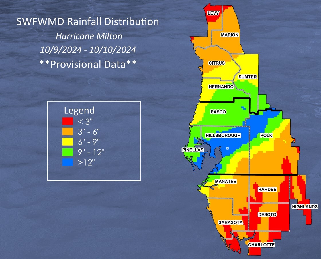
- Hurricane Milton brought heavy rainfall to our region, especially the headwaters of the Withlacoochee River.
- Some areas of the Green Swamp received close to 16 inches of rain overnight on Wednesday.
- All this rainfall fell on creeks, swamps, ponds, and lakes that were already high from above average summer rains.
- For the Withlacoochee River in particular, major flooding is expected as this rainfall has drastically increased river flows causing water levels to rise substantially in the coming days/weeks.
Little Withlacoochee River (Sumter/Hernando Counties):
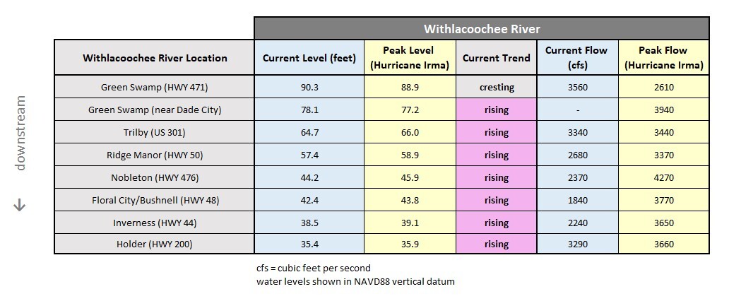
- The Little Withlacoochee River at US 301 rose 7 feet over the past 3 days and is currently the highest it’s been since 1960.
- River levels are now more than 1.5 feet higher than the peak from Hurricane Irma in 2017.
- The river at US 301 appears to be cresting but could rise further as floodwaters drain from the Green Swamp.
- This is catastrophic flooding for the Little Withlacoochee River.

Withlacoochee River (Green Swamp to the Gulf of Mexico):
Green Swamp
- Current flooding in the Green Swamp is the highest it’s been since 1960, surpassing both the peaks from Hurricane Irma (2017) and the 2004 hurricanes.
- The Withlacoochee River at SR471, in the middle of Green Swamp, is now cresting at its highest level in over 6 decades.
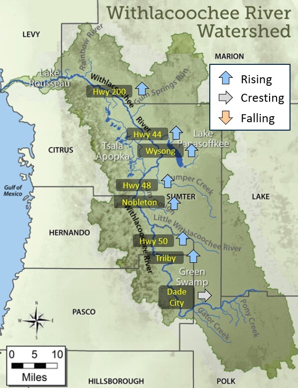
- At the Dade City gauge on the west side of the Green Swamp, river levels have risen 5.5 feet in the past 3 days and may crest in the next day or so.
- This is an ominous sign for the remainder of the Withlacoochee River as all this floodwater must make its way downstream, causing water levels to rise to historic levels.
- There are no water control structures in the Green Swamp that could hold back or divert any floodwaters.
Trilby and Ridge Manor
- The Withlacoochee River at Trilby (US301) has risen over 7 feet in the past 3 days and is now less than 16 inches below the peak from Hurricane Irma.
- The National Weather Service is currently predicting Trilby to rise another 2 feet by next Saturday (10/19). This could surpass the Hurricane Irma peak by about a foot.
- Near Ridge Manor (SR50) the river has also risen over 6 feet since Milton and is expected to continue rising for at least another week.
- Flooding at Trilby and Ridge Manor are projected to be the highest they’ve been since 1960.
Nobleton and Hwy 48
- Downstream at Nobleton (CR476), the Withlacoochee River has already risen 2 feet and will continue rising for another 10 days at least, possibly cresting on 10/22 or 10/23.
- At Hwy 48 (between Floral City and Bushnell), river levels have risen over a foot since Milton and could continue rising for another 2 weeks (peaking around 10/25).
- At both Nobleton and Hwy 48, flood levels are expected to exceed the peaks from both Hurricane Irma (2017) and the 2004 hurricanes, rising at least another 2 feet in those areas.
Hwy 44 and Hwy 200
- River levels at Hwy 44 have risen 1.5 feet in the past 3 days and are already within 7 inches of the Hurricane Irma peak (2017). And they may rise another 2-3 feet.
- At Hwy 200 (Holder), the Withlacoochee River has already risen over 2 feet since Milton and is now only 6 inches below Irma flood levels.
- The National Weather Service is currently predicting Hwy 200 will rise another foot by Wednesday, but it will end up much higher than that.
- The river at Hwy 200 could rise another 3-4 feet by early November, which would be major flood stage and higher than we’ve seen in over 6 decades.
- The peak flooding at Hwy 44 and 200 won’t occur for another 3-4 weeks.
Dunnellon and Lake Rousseau
- At Dunnellon (Hwy 41), the Withlacoochee River is expected to rise as floodwaters make their way down river.
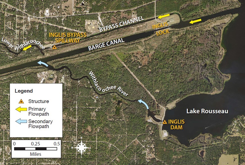
- On Lake Rousseau, the Inglis Dam, which was opened on August 3rd, remains open discharging excess flows to the Barge Canal.
- Lake Rousseau was lowered prior to Hurricane Milton to create room for heavy rainfall that filled it back up in 24 hrs.
- The lake is being lowered yet again as river levels upstream near Dunnellon continue to rise.
- The Inglis Dam has no effect on river levels upstream near Hwy 200. Flooding from the Green Swamp downstream past Hwy 200 is the result of natural river flows and channel bottom elevations (topography).
Lower Withlacoochee River
- After severe coastal flooding from Hurricane Helene, the Lower Withlacoochee River was spared from any major storm surge during Hurricane Milton.
- The Inglis Bypass Spillway is fully open, discharging high flows to the Lower Withlacoochee River.
- The Inglis Dam is also open discharging rising river flows into the Barge Canal.
Tsala Apopka Chain of Lakes (Citrus County):
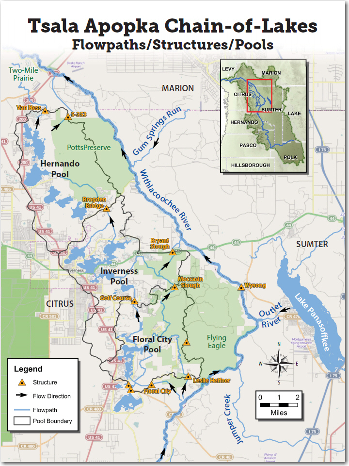
- All three pools of the Tsala Apopka Lake Chain rose 7-9 inches from Hurricane Milton rainfall.
- Prior to the storm, structures were open releasing water to create storage.
- All structures that release water from the lakes remain open helping to lower lake levels.
- The Floral City and Inverness Pools are currently above their high levels, while the Hernando Pool is slightly below its high level.
- We’ll continue releasing water from the lakes into both Two-Mile Prairie and the Withlacoochee River at SR 200 for the next couple weeks.
- This will create some room and allow us to divert some of the floodwater from the Withlacoochee River back into the lakes when river levels are peaking.
- At that point, we’ll stop releasing water back to the river at Hwy 200 to prevent the river there from rising any higher.
- We cannot lower the Withlacoochee River or prevent it from flooding, but we’ll do everything we can to help.
Lake Panasoffkee and Wysong Structure (Sumter County):
- Lake Panasoffkee has risen about 15 inches the past 3 days in response to Hurricane Milton.
- Inflows to the lake from Little Jones Creek and Shady Brook are the highest they’ve been in over 40 years.
- The Wysong Structure on the Withlacoochee River, which was fully lowered in early August, remains fully lowered.
- Prior to Hurricane Milton, river levels at Wysong were 6 inches below their normal level.
- Lake Panasoffkee is expected to rise for at least 2 more weeks, as upstream floodwaters drain into the lake and the Withlacoochee River downstream remains high.
My thoughts and prayers are with each of you impacted by flooding from Hurricane Milton. If you need any information, don’t hesitate to reach out.
-Mark
Mark Fulkerson, Ph.D., P.E.
Chief Professional Engineer
Southwest Florida Water Management District
(352) 269-6073 (office)
(352) 279-4493 (cell)

