Withlacoochee River Conditions Update - 8/7/2024
Southwest Florida Water Management District sent this bulletin at 08/07/2024 03:14 PM EDTUpdate on Withlacoochee River Conditions
Good news is the NWS flood predictions are less severe than first expected, but we need to stay vigilant because the river is still rising, and additional heavy rainfall that occurs in the coming weeks could worsen conditions.
Note: In the update below, I’ve included links to the USGS gauge conditions so you can keep an eye on what the river is doing at different locations.
Little Withlacoochee River (Sumter/Hernando Counties):
- The Little Withlacoochee River in currently in flood stage but it has peaked for now at the US301 bridge.
- River levels are about a foot lower than the high levels that were observed after Hurricane Irma in 2017 and the summer flooding of 2019.
- The Little Withlacoochee is still slowly rising upstream in the Green Swamp, so we could see higher levels between US301 and Silver Lake (where most of the homes are) before conditions return to normal.
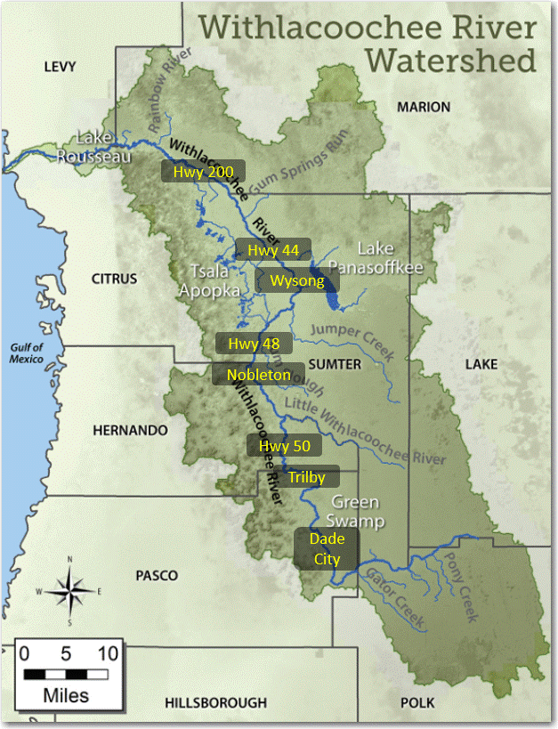
Withlacoochee River (Green Swamp to the Gulf of Mexico):
Green Swamp
- Withlacoochee River levels are peaking at SR471 in the middle of the Green Swamp, but the river is still rising at the Dade City gauge on the west side of the Green Swamp.
- Compared to Hurricane Irma in 2017, river levels in the Green Swamp are much lower for now, so that is a good sign that we won’t see significant flooding downstream.
Trilby and Ridge Manor
- The Withlacoochee River at Trilby (US301) and Ridge Manor (SR50) is still rising and that will continue over the next week at least.
- Currently, river levels there are 10 feet lower than the peak in 2017 (Irma). The National Weather Service is predicting Trilby to reach action stage by Sunday afternoon but it could still approach minor flood stage next week.
Nobleton and Hwy 48
- Downstream at Nobleton (CR476) and Hwy 48, river levels are also still rising and likely won’t peak for another week or two. Again, I’d expect river levels to be lower than we saw with both Irma (2017) and the 2004 hurricanes (Charley, Frances, Jeanne).
- At Nobleton and Hwy 48, the river is currently 3 to 4 feel lower than the high levels observed after Hurricane Irma (2017).
Wysong, Lake Panasoffkee, and Tsala Apopka Lake Chain
- The Wysong structure is now almost fully lowered in response to rising river levels.
- Lake Panasoffkee continues to slowly rise from increased flows in Shady Brook and Little Jones Creek.
- The Tsala Apopka Chain of Lakes have leveled out from the storm’s rainfall and structures remail closed as the lakes are still several inches below their normal high levels.
Hwy 44 and Hwy 200
- At Hwy 44 the Withlacoochee River appears to be leveling off from the recent increases, but there will be another rise in levels in the coming weeks as the flood waters make their way downstream.
- Currently the river here is 2 ½ feet lower than the highest it reached after Irma (2017).
- At Hwy 200 (Holder), the Withlacoochee is also still rising. Right now, levels are about 6 feet lower than the Hurricane Irma peak, but we can expect the river will rise again and crest in 2-3 weeks as the high flows make their way downstream.
- The National Weather Service is not showing any flood predictions yet for Hwy 200, because its too far out, but I recommend monitoring the forecast site for this location over the next couple weeks.
Dunnellon and Lake Rousseau
- At Dunnellon (Hwy 41), the Withlacoochee reached minor flood stage on Monday night (from local rainfall) but we’ve kept the Inglis Main Dam open and Lake Rousseau lower than normal to help bring the river at US41 back down.
- The Inglis Main Dam was opened on Saturday, in preparation of the storm, and the west end of Lake Rousseau has been lowered 7 inches to assist Dunnellon.
- Lowering Lake Rousseau with this Dam has no effect on high water very far upstream of Dunnellon and cannot prevent flooding at Hwy 200.
Lower Withlacoochee River
- The Lower Withlacoochee River rose 3-4 feet higher than normal on Monday into Tuesday due to storm surge and high tide from Hurricane Debby but is back down to the normal tide cycle again.
- No water from Lake Rousseau was released down the Lower Withlacoochee River during that time.
- Thankfully, the Lower Withlacoochee peaked several feet lower than the flood levels observed after Hurricane Idalia last fall.
I know this is a lot of information, but I wanted to keep you informed of any changes.
Hope you enjoy the rest of the week, and I’ll reach out again with any new developments.
-Mark

Mark Fulkerson, Ph.D., P.E.
Chief Professional Engineer
Southwest Florida Water Management District
(352) 269-6073 (office)
(352) 279-4493 (cell)

