Withlacoochee River - Hurricane Debby Update - 8/5/2024 - Corrected
Southwest Florida Water Management District sent this bulletin at 08/05/2024 06:04 PM EDTHurricane Debby Update - Withlacoochee River
Just wanted to give you a quick update on Withlacoochee River conditions following Hurricane Debby.
Rainfall and Withlacoochee River Flooding:
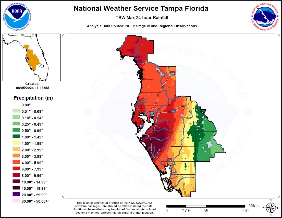
- Over the past 24 hours, the entire Withlacoochee River Watershed received 4 to 8 inches of rainfall (see rainfall graphic below).
- This has caused a tremendous amount of water to flow into the river in a short period of time.
- Both river levels and flows continue to quickly rise along the river from the Green Swamp past Hwy 200.
- There are no structures in the Green Swamp, and we have no control over how high the river gets or how much flow passes down the Withlacoochee River in this area.
- If you live in a low-lying area or one that is prone to flooding along the Withlacoochee, please take the appropriate action to protect yourself and your property.
- Flooding impacts along the Withlacoochee River can occur long after the storm has passed.

River Predictions:
- The National Weather Service (NWS) is predicting the Withlacoochee River will reach flood stage in the coming days.
- For predictions on how high the river may rise, click on the link below to access the NWS Southeast River Forecast Center.
https://www.weather.gov/serfc/
- This link includes river predictions for the entire southeast, but there are 4 gauges on the Withlacoochee River.
- These predictions will change, so check this link periodically for updates.
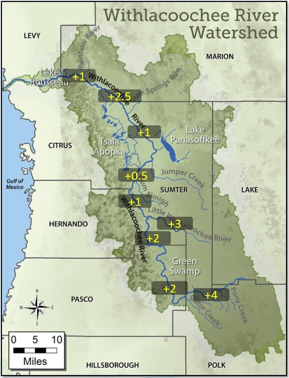
- Over the past 24hrs, the Withlacoochee River has risen several feet in some areas and will continue to rise in the days to come.
- For areas farther downriver like Hwy 200, it may take 2-3 weeks before the river peaks from this storm event.
- At this time, I don’t think we’ll see the river rise as high as it was after Hurricane Irma in 2017, but we are continuing to monitor conditions and I’ll keep you informed of any major developments.
Other Lakes and Water Control Structures:
- All three pools of the Tsala Apopka Lake Chain rose about 7 inches since yesterday. Structures remain closed at this time.
- Lake Panasoffkee also rose 7 inches in the past 24 hours.
- The 19-ft wide independent gate at Wysong structure was fully lowered Saturday night.
- The 230-ft wide main gate at Wysong has been significantly lowered in response to rapidly rising river levels.
- Lake Rousseau was lowered several inches prior to the storm. This allowed us to close the Inglis Bypass Spillway during the storm surge and high tide cycles on the Lower Withlacoochee River.
- The Inglis Main Dam was opened to account for the excess water entering Lake Rousseau and to keep the west end of the lake down about 5-6 inches, to assist with the current high water at Dunnellon.
River Level Changes (feet) in the past 24 hours (levels are still rising and have not peaked yet)

Stay safe!
Mark
Mark Fulkerson, Ph.D., P.E.
Chief Professional Engineer
Southwest Florida Water Management District
(352) 269-6073 (office)
(352) 279-4493 (cell)

