 Water Levels in Key South Florida Water Bodies
-
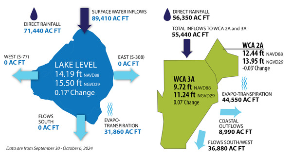
Lake Okeechobee: 14.19 ft NAVD88 (15.50 ft NGVD29),1.22 ft. below Zone BC and 2.53 ft. above the Water Shortage Management Zone
-
WCA 2A: 12.44 ft NAVD88 (13.95 ft NGVD29), 1.05 ft above regulation schedule
-
WCA 3A: 9.72 ft NAVD88 (11.24 ft NGVD29), 0.89 ft above regulation schedule
The U.S. Army Corps of Engineers is the primary agency responsible for Lake Okeechobee management. The Lake Okeechobee System Operating Manual (LOSOM) Record of Decision was signed on August 12, 2024. The South Florida Water Management District continues closely monitoring algal activity, oysters, sea grass, and other conditions in and around Lake Okeechobee.
Publicly-Available Resources
Learn More About Long-Term Projects to Improve Water Management in South Florida
The South Florida Water Management District remains committed to advancing projects to improve water levels and reduce harmful discharges to the Northern Estuaries. Learn more here.
To sign up for weekly updates on South Florida’s water conditions, visit our email signup page. Enter your email address and check the “Key Water Conditions, including Lake Okeechobee Discharges” box.
Note: The data in this report are for September 30 - October 6, 2024 and the total volumes are reported in acre feet (AC FT). All data provided in this update are provisional and subject to quality assurance and quality control review. Change in stages are calculated based on average daily stages of waterbodies and may not fully capture the actual stage change over the week. Water levels (“elevations”) represent the average for the day.
The SFWMD upgraded the reference system used to measure water elevations. The water elevation readings, also known as water level readings, are now being reported in the newer North American Vertical Datum of 1988 (NAVD 88), instead of the National Geodetic Vertical Datum of 1929 (NGVD 29). While there is no difference in the actual water level, the water level readings in the NAVD88 measurement system will read about 0.6 feet to 1.6 feet less than the readings in the older NGVD 29 measurement system.
For a period of time, the SFWMD will maintain both measurements in this weekly water level update email and in our environmental database known as DBHYDRO. To learn more about NAVD 88, visit SFWMD.gov/NAVD.
|