Brian Branciforte
Recently at a conference a state agency representative was giving a presentation about private lands conservation programs. The audience seemed more interested in the next snack break rather than the materials on the 12-slide bulleted PowerPoint. The next speaker got up and moved slowly toward the podium. He looked under-dressed, nervous, and a little out of his element. The speaker was a private landowner enrolled in one of the previously mentioned programs. There were no slides or prepared speech. He simply spoke from the heart about his passion for his way of life, the land, and his ethics toward conservation. The audience was charmed and captivated. This exemplifies one of the benefits of a partnership-based approach. Different partners bring different perspectives toward a similar goal.
Left: James Bond's famous line about his preference for vodka martinis - "shaken, not stirred" was a funny inspiration for this article
Partnerships are formed in many disciplines of practice, and in conservation, they are fundamental and necessary in doing business and achieving success. That’s because our natural resources (wildlife and habitats) cut across so many issues intricately linked to our way of life whether it is our health (clean air and water), business (tourism) or culture (outdoor recreation), to name a few examples.
Long-term and statewide conservation of Florida’s natural resources requires the combined activity of many partners in agencies, organizations, businesses and individuals in both the public and private sector. Working together as partners demands a shared vision, which can be used to create goals and measure the progress of our collective efforts.
Florida’s Wildlife Legacy Initiative is working to provide a shared vision, or blueprint, to promote and coordinate our limited resources in a proactive manner and to engage with partners to define priorities and leverage resources. The State Wildlife Action Plan serves as the basis for a statewide conservation plan, while the Florida’s Wildlife Legacy Initiative Implementation Goals provide a venue to participate and conserve priority resources. Partnerships enable the pooling of resources to gain trust, information, capacity and finances.
Articulating, gaining buy-in and measuring progress on a shared conservation blueprint is a monumental challenge. However, it is required. A successful future for fish and wildlife in Florida ultimately will be determined by our ability to weave diverse interests together in a manner that creates a shared vision and ownership of the benefits that flow from conservation.
|
Back to top
Allie McCue
I am so glad you asked! Last September, our newsletter highlighted the long road we have taken to reach the end of a major revision of the State Wildlife Action Plan. Approximately six weeks later, we submitted the final product to the U.S. Fish and Wildlife Service for approval. To say we were happy was an understatement!
Florida’s Wildlife Action Plan was revised previously in 2012, and we know that the review and approval process can take some time. Each revised Action Plan is reviewed by a small team that consists of FWS regional staff and other state wildlife agencies. And despite the reduction of nearly 300 pages from the previous Action Plan, a thorough review can not be done quickly. Stacked on top of that large task, we were knocking on the door of the holiday season, which was immediately followed by a federal government shutdown. We are hopeful that the Action Plan will be reviewed (and approved) in the coming months.
Until then the Florida Wildlife Legacy Initiative is diligently working on implementation strategies, monitoring efforts, communication and continued partnerships benefiting Florida’s Species of Greatest Conservation Need and their habitats. Stay tuned for future updates and contact Allie McCue with any questions at Allie.McCue@MyFWC.com.
|
Back to Top
Andrea Alden and Elizabeth Crisfield
A Regional Species of Greatest Conservation Need list has proven to be a powerful tool for enhancing cross-state collaboration and successful conservation of wildlife species in the northeastern United States over the last 20 years. Southeastern states are now following suit, with development of their own RSGCN list.
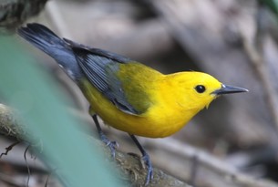
Left: The prothonotary warbler is one of Florida's Species of Greatest Conservation Need
Terwilliger Consulting, Inc., which provided primary support to northeastern states in developing their regional list, is facilitating the effort with the Southeastern Association of Fish and Wildlife Agencies’ Wildlife Diversity Committee, RSGCN Working Group members, National Wildlife Federation, Southeast Conservation Adaptation Strategy and state taxa experts. Since March 2018, two meetings, a survey and numerous conference calls have helped these partners develop a set of criteria for selecting RSGCN that reflect the specific context and needs of the southeastern U.S., including, regional stewardship responsibility; conservation concern and status; and biological/ecological significance. The project is now in the final phase, convening taxa teams to review all vertebrate SGCN (and several invertebrate groups) to determine which species meet the criteria to be listed as RSGCN.
The region aims to use the RSGCN list to more effectively conserve fish and wildlife, by identifying high priority species that would benefit from multi-state collaboration, highlighting shared conservation concerns, communicating regional conservation priorities with partners and funding programs, and raising awareness of the southeast’s unique biodiversity and stewardship responsibilities.
A draft of the southeast’s RSGCN list should be completed early this spring. For more information, please contact Andrea.Alden@MyFWC.com.
|
Back to Top
Sandy Mickey
 In late November, I posted a simple request on Twitter that changed the world for our son, Jack. He is a 5-year-old with a rare spine condition who wears a permanent plaster cast around his body to help train his spine to grow straight. He was set for surgery #22 for a new cast at the Shriners Hospital for Children in Greenville, S.C. It’s a normal part of our lives, and other than not being able to take baths or go to the pool, he is a normal child. But the two to three hours after each surgery, as Jack comes out of anesthesia, are the exception. He is fussy and restless. We try each time to distract him, so the doctors and nurses can finish up their care. Jack loves turtles. I asked my followers if they could tweet turtle pics from the field and address them to Jack. That just might distract him for a bit.

The post went viral. We received over 1,000 turtle pictures, videos, and stories from around the world. The Washington Post did an article. The magic of that week continued when my own agency jumped in and spent all day tweeting pictures and facts about sea turtles for Jack using the hashtag #Turtles4Jack. Many of my Florida Fish and Wildlife Conservation Commission (FWC) colleagues also posted and emailed turtle pics for him to look at.
There is nothing like community support. But what made that week so incredible was the outpouring of support from my agency. To all of my FWC friends, our whole family thanks you. It is unbelievable -- the compassion, support and love we received from you -- and it all makes working for the FWC all the more special.
|
Back to Top
Sarah Sharkey
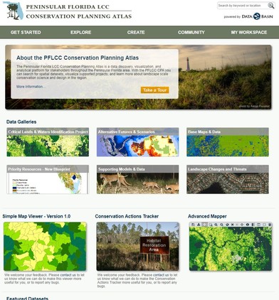
The Florida Conservation Planning Atlas (CPA) allows stakeholders throughout the state to work collaboratively with ease. The CPA is a platform that provides tools for data visualization, data sharing and access to the Florida Conservation Blueprint.
The Florida CPA is an excellent resource for anyone who wants to collaborate about conservation. The platform is set up beyond firewalls, allowing for easier collaboration across agency lines. The group feature within the CPA enables users from various agencies to work together beyond traditional restrictions with a select group of appropriate partners. Within a private group, partners can share information and data in a user-friendly environment.
Many, if not all, conservation goals are influenced by a variety of partner groups. The range of partners for any given conservation effort can include nonprofits, state agencies, federal agencies and more. Each partner has its own valuable contribution to the overall conservation effort. Unfortunately, sometimes it can be difficult for all partners to come together in a meaningful way. The Florida CPA aims to remove these barriers and allow stakeholders to interact in a meaningful way.
Data shared on the CPA is accessible through various tools including Simple Map viewer, Advanced mapper and the Conservation Actions Tracker. Each tool has different strengths that users can use to share, access and analyze data made available on the CPA.
The Florida CPA has several galleries of spatial data sets and supporting documentation available for users. Currently, there are six galleries of information made available on the CPA. One notable gallery is the Priority Resources gallery that offers access to the Florida Conservation Blueprint. The FCB identifies conservation assets across the state and determines areas to prioritize conservation action. The goal of the FCB is to provide decisionmakers with a guide to prioritize conservation actions around the state. Importantly, this data is made readily available through the CPA. As a user, you will be able to create organized galleries of your data to share in a similar way.
If you would like to learn more about the CPA, or would like an individual or group tutorial, contact Sarah Sharkey, the user support specialist, at sarah.sharkey@myfwc.com. If you are interested in using the Conservation Planning Atlas, then create an account to get started.
|
Back to Top
Anna Deyle
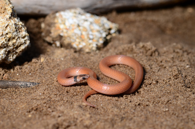
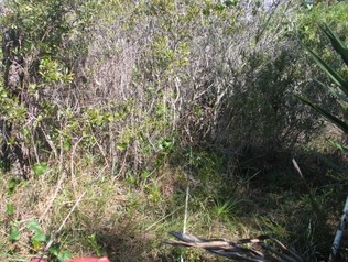
The coastal dunes crowned snake (Tantilla relicta pamlica) is a subspecies of the Florida crowned snake that resides in loose, sandy soil on the Atlantic coastal ridge of Florida. Due in part to its nature as a small, burrowing species, there is very little information available on this snake. Only a limited number of historical records of the snake have been documented, all of which have been found on the Atlantic coastal ridge (Volusia to Palm Beach County). Very few comprehensive studies have been done on Florida crowned snakes, none of which focused on this subspecies. Because of its small range and limited data, the coastal dunes crowned snake has been categorized as a species of greatest conservation need in Florida’s State Wildlife Action Plan.
|
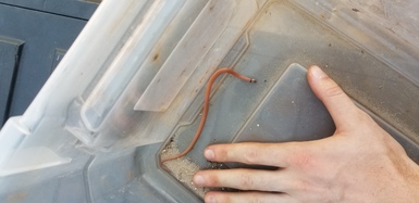
The FWC’s Wildlife Legacy Initiative and Regional Operations Subsection are collaborating with partners who manage public lands in the agency’s Northeast region within the species’ habitat (Volusia, Brevard, and Indian River Counties) to identify the basic distribution of this snake and document the habitats it is using. FWC staff also are collecting genetic samples to contribute to an ongoing genetic assessment of Florida crowned snakes at the University of Florida to identify its relationship to the other two subspecies of Florida crowned snakes. Filling this gap in distribution and taxonomic knowledge for the coastal dunes crowned snake (CDCS) will help inform decision-making as to whether the snake meets criteria to be listed as a state-threatened species or subspecies. It will also provide preliminary information on areas potentially critical to CDCS conservation. With funding from a Conserve Wildlife Tag Grant provided by The Fish and Wildlife Foundation of Florida, the objectives of this study are to:
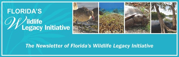
- Determine the effectiveness of carpet tile cover objects (see photo) as a methodology for surveying CDCS.
- Conduct presence surveys of CDCS on public lands in Volusia, Brevard and Indian River Counties.
- Collect genetic samples to assess the taxonomy of this subspecies in relation to the other Florida crowned snake subspecies.
|
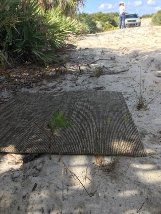
This study began in July 2018 and will continue through April 2019. Using 24” x 24” carpet tiles as cover objects, sites are set up in scrub, sandhill, coastal strand and xeric hammock habitat along the Atlantic coastal ridge and checked weekly. Carpet was suggested as the preferred cover object material because it easily conforms to the sand and provides cover for these snakes. Sean McKnight was hired as the field technician for the project to check cover objects daily, identify new sites to sample and process snakes for the project’s duration. To date, this study has resulted in the capture and sampling (size and shape measurements, photographs, habitat assessment, and genetic sampling) of three CDCS. Additionally, two new CDCS records have been acquired from Brevard County employees based on GPS locations, dates and photo documentation to add to historic records.
Major partners for this project include: FWC’s Wildlife and Habitat Management Section, Brevard County’s Environmentally Endangered Lands Program, U.S. Fish and Wildlife Service, U.S. Air Force, and Florida Department of Environmental Protection. Genetic assessments for this project are being conducted by Dr. Coleman Sheehy with the University of Florida. For more information about this project, please contact Anna Deyle, NE Wildlife Legacy Biologist (Anna.Deyle@MyFWC.com) or Tyler Turner, NE Assistant Regional Biologist (Tyler.Turner@MyFWC.com).
Note: This article first appeared in the Coastal Wildlife Conservation Initiative newsletter.
|
Back to Top
Thomas Kuhn
Hurricane Michael struck the Florida panhandle in October 2018 as a Category 4 storm in a swath stretching from Panama City Beach to the Big Bend on the coast and up through the state’s rural interior, exiting into Georgia as a Category 3 storm. FWC staff living in the impacted area have been working to assess the impacts to Florida’s wildlife and their habitats, while working to restore our own homes. In the days soon after the storm, I drove to see examples of several different ecosystems to view them and begin trying to understand the impacts of the storm. These are my observations, made from my perspective as both a regional and freshwater biologist.
Forests
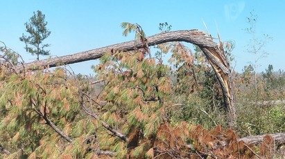
Pine forests abound throughout northwest Florida. Many of these forests are managed, some for timber and others specifically for wildlife. The FWC offers assistance in the management of these forests to help improve their function as wildlife habitat. Traveling north and east into Calhoun County along the storm’s path with members of the FWC’s Office of Conservation Planning Services to check on landowners enrolled in the agency’s Landowner Assistance Program, we saw downed pines all around. Trees throughout the impacted area lay twisted, snapped, bent, uprooted or in some combination of all four conditions, and stripped of leaves and needles.
|

In places where the hurricane’s eye passed over, some trees were bent in one direction and neighboring trees were snapped in the opposite direction. This was due to the spiraling counterclockwise movement of the hurricane’s winds, with areas hit by the northern eyewall subjected to winds blowing westward and after the passage of the eye, they then were hit by the southern eyewall with eastward blowing winds. It resulted in some trees falling to the westward winds, and others to the eastward winds.
|
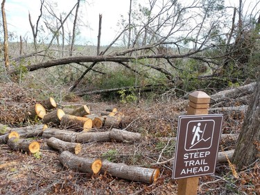
Beaches
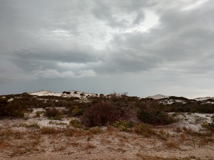
St. Andrews State Park is located in Bay County on the western side of the inlet into St. Andrew Bay. A network of protected dunes lays between the Gulf and upland portions of the park. These dunes provide habitat for wildlife including shorebirds and beach mice and serve as a storm break, protecting the upland areas from storm surge and high waves. Multiple beaches in the park also offer opportunities for people to engage in snorkeling, sunbathing, splashing and wildlife viewing. Driving through the park, the dunes looked intact from the landward side, though high winds had flattened several structures. It appeared that the park’s dunes had successfully protected the uplands from storm surge.
|
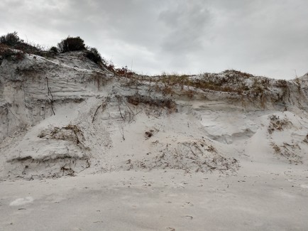
Seen from the seaward side, it also was clear that this protection came at the cost of portions of the dunes themselves. Standing where the dunes once gradually sloped down to the beach, sandy cliffs now towered in places where the dunes seemingly had been cut in half by the winds and the rising and falling waters.
|
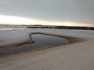
Fish lay stranded on the beach, some dead from exposure, others likely washed ashore dead as victims of the red tide bloom. The jetty rocks encircling the “kiddie pool,” a shallow protected area between the beach and the jetty rocks bounding the inlet, were exposed more than typical, and the pool itself was shrunken and shallow due to sand from the dunes washing into the pool and being trapped by the rocks.
|
 |
|
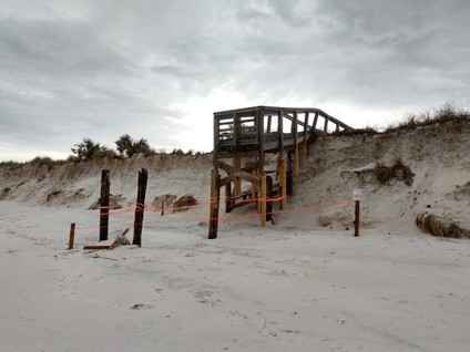
Boardwalks and foot bridges that typically sit just inches above the dunes now stood exposed in the air.
Signs for protected critical habitat lay on the beach, with the habitat itself having washed out to sea.
|
Wetlands
The forests and ephemeral wetlands of St. Marks National Wildlife Refuge, located in Wakulla, Jefferson and Taylor counties, were largely spared from the wind damage seen further west. But they were subject to storm surge that inundated freshwater ponds, leaving them with saltwater and salt concentrations orders of magnitude greater than usual, just before the beginning of the breeding season for multiple species of sensitive fall and winter breeding amphibians. Standing by the ponds you could smell the salt in the air far from where you would expect a sea breeze. Prior to my arrival with staff members from the FWC’s Species Conservation Planning and Aquatic Habitat and Restoration Enhancement sections, staff at St. Marks had removed multiple tussocks of vegetation that had been lifted out of nearby ponds and deposited on park roads by the rising and receding storm waters. Much of this vegetation had been of an invasive marsh grass species, so that was a rare immediately positive impact of the storm.
Streams and Springs
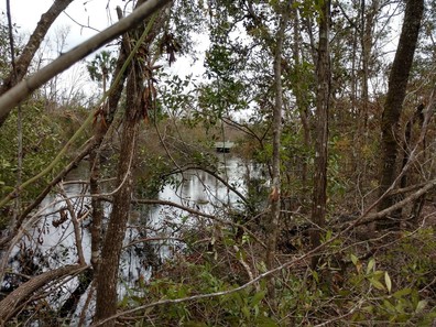
Paddling on Econfina Creek past several springs in Washington County is a popular outdoor recreational activity. The water is clear, and the cool temperature of the springs is refreshing. Snorkelers can view aquatic life ranging from fish to tadpoles to snails and watch small pebbles dance in the up-flowing currents of the underwater springs. Traveling up to Pitt Springs in Washington County after the hurricane, I found downed trees and waterways choked with tree debris. Highway 20 crosses over Econfina Creek near the spring via a bridge that is normally well above the heads of paddlers. On my visit a few weeks after the storm, the water was only about a foot below the bridge.
|
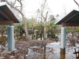
At various points before and after that visit, the bridge had to be closed due to the height of the water. Pitt Springs, which is managed by the Northwest Florida Water Management District, has a series of walking trails nearby, in addition to a picnic area and a set of stairs descending to the waters of the spring pool itself. At the time of my visit, the area was closed to the public, due to downed trees and rising water levels. The picnic area was flooded, the stairs underwater and the surrounding wetlands inundated with flowing water.
|
The walking trail through the forest was impassible with trees down everywhere. NWFWMD staff had clearly been hard at work clearing fallen trees, but behind every cleared tree were several more downed or broken trees.
Rivers and streams throughout the area were similarly affected. The floodplain forests of the Apalachicola and Chipola rivers were inundated, as could be seen when crossing the rivers on Interstate 10 and Highway 20. Boat ramps on local rivers were flooded and inaccessible.
|
Closing thoughts
The ecosystems of Florida are disturbance-dependent systems. Fire is the dominant historical disturbance and is consequently a major component of our management strategies. But hurricanes and tropical storms also provide elements that are important to our habitats. We find ourselves with rivers full of woody debris, which provides homes and food for aquatic insects and other invertebrates that are in turn consumed by fish, which shelter in the debris as well. Flooded forests provide access to nutrients and spaces that riverine species use for foraging and spawning. Forests with decreased canopy densities may in time lead to the return of ground cover that previously didn’t receive enough light to thrive. Open pine savannahs provide prime habitat for species such as gopher tortoises, eastern indigo snakes and more. Beaches and dunes are dynamic systems by their very nature, shifting with wind and wave. Without those elements, they would be overgrown and shift into habitats not suitable for shorebirds, beach mice and sea turtles.
With time the immediate negative impacts of the storm to our wildlife and their habitats, and to our ability to view and enjoy them, will fade to long-term benefits enjoyable by all.
Immediately after the storm, the FWC made it clear the health and safety of the people who lived in the area were its number one priority. As the area recovers, the FWC is still involved and will be involved in the recovery for many months to come. The trauma experienced by the people who live here was difficult, but they are as resilient as our wildlife and habitats.
Back to Top
We don't always take enough time to celebrate hard work and amazing accomplishments. Florida’s Wildlife Legacy Initiative is recognizing a few of the following principal investigators who finished their State Wildlife Grant-funded projects recently. These projects demonstrate the wide variety of conservation efforts taking place in Florida – from research and on-the-ground restoration to management, mapping and monitoring. For more information on the following projects, please contact Andrea.Alden@MyFWC.com or Robyn.McDole@MyFWC.com
Congratulations to all on work well done!
Statewide Survey and Nest-site Selection Patterns of Reddish Egrets
Principal Investigator: Andrew Cox, Florida Fish and Wildlife Conservation Commission
A statewide survey of nesting reddish egrets funded in 2014 was done by FWC researchers to provide a baseline population size for population monitoring and to identify the largest breeding colonies in Florida to help prioritize future management activities.
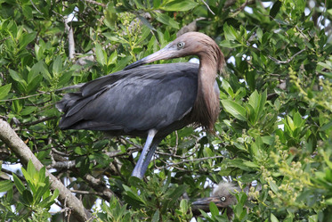
Right: Reddish Egret. Photo Credit: Anne Macias
The reddish egret (Egretta rufescens) is a state-listed threatened species, due to its small population size, population declines and restricted distribution. The researchers selected breeding sites based on historical data and conducted surveys to estimate the number of breeding reddish egret pairs at 305 sites throughout Florida. Birds were fairly evenly distributed across core nesting areas, with 78–86 pairs in southwest Florida, 54–88 pairs in Florida Bay, 95 pairs in the lower Florida Keys and 34–43 pairs in or near Merritt Island National Wildlife Refuge. No nesting birds were observed north of Merritt Island on the Atlantic coast or north of Cedar Key on the Gulf coast.
Researchers also used the location and abundance of surveyed nesting reddish egrets to identify the social and habitat features influencing the likelihood of reddish egret presence and the abundance of nesting reddish egrets. The project results suggest the following management efforts are most likely to prove beneficial to reddish egrets:
- Effective management of large species-rich coastal rookeries
- Coastal restoration efforts that closely link nest site management with high quality foraging habitat
- Better knowledge of how sea level rise will alter the location and extent of foraging habitat.
This reddish egret project was funded through the Florida Wildlife Legacy Initiative’s Data Gaps Goal.
|
|