|
Fall 2015
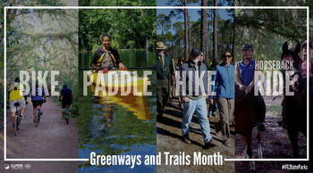
October is Florida Greenways and Trails Month and that usually means drier, cooler days—perfect for getting outdoors! Take some time to explore a wooded path or glide down your favorite river or stretch of coastline.
The Office of Greenways and Trails, within the Florida Department of Environmental Protection’s Division of Recreation and Parks, welcomes this annual occasion to highlight the variety of local and regional trail activities throughout the state and their health and economic benefits.
For paddling enthusiasts, several statewide events are scheduled. These include the 13th annual Florida Paddlers' Rendezvous along the Suwannee River October 16-18, the Paddle Florida Suwannee River Wilderness Trail trip October 22-27, and several guided day trips in Florida state parks. Also, 16 paddlers will be part of the annual Apalachicola RiverTrek October 6-11 to support the Apalachicola Riverkeeper. This year, there is another contingent bicycling along the entire Apalachicola River corridor.
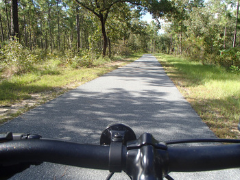
Bicycling events are highlighted by the Suwannee Fat Tire Festival October 23-25, and don’t forget the always fun Ride of the Living Dead cycling event on the Cross Florida Greenway October 24. There are two ride options—22 or 50 miles. Dress up in your best Halloween costume for the contest!
Florida state parks are offering a variety of local trail-related events. Find an event near you! And keep checking the Florida Greenways and Trails Community Calendar for scheduled trail events throughout the year, and the online trail guide for places to go. Florida has more than 8,000 miles of land-based trails and 4,000 miles of paddling trails that provide vast benefits for Florida's economy and tourism and the health and well-being of trail users.
The Shared Use Nonmotorized (SUN) Trail Network
is a program with dedicated funding to implement paved trails.
The trails
community was excited to learn that establishing a connected paved trail system
recently took a big step forward. Beginning in 2015, the Florida Department of
Transportation (FDOT) will be allocated $25 million annually
from new vehicle tag fees to
expand the statewide network of paved trails. Expanding the state’s trail
network has the potential of producing numerous economic benefits, including
increasing spending at local businesses, influencing business location,
revitalizing depressed areas, providing sustainable tourism opportunities and
creating jobs.
The SUN Trail Network
is a component of the 2013-2017 Florida Greenways and Trails System (FGTS) Plan.
In 2014, the FDOT was directed to give funding priority to trail projects of
national, statewide or regional importance identified within the FGTS Plan, support
the transportation needs of bicyclists and pedestrians, and facilitate an
interconnected system of trails by completing gaps between existing trails. As FDOT or a certified contractor completes a trail's construction, another entity will operate and maintain it.
The FGTS Plan
is the responsibility of the Florida Department of Environmental Protection,
Office of Greenways and Trails (OGT). As a basis, the agencies are using the
publicly reviewed and approved 2013-2017 FGTS Plan and the Priority Land
Trails network that was adopted in 2012 for the plan. The Priority Land Trails map
and 2013-2017 FGTS Plan were adopted through an extensive public process and approved
by the Florida Greenways and Trails Council, a
group consisting of local, state, and federal land managers, a representative
from the FDOT, and citizens who use trails and greenways.
The process of
identifying the statewide trail system begins at the local level, with hundreds
of smaller potential trails of varying lengths submitted by municipal and
county governments and regional planners to OGT. In December 2015, OGT will
recommend approval of an update to the statewide Opportunity Map of land and
paddling trail corridors to the Florida Greenways and Trails Council. Following
the Opportunity Map update in 2015, then OGT will evaluate these corridors in
relationship to the 2013-2017 FGTS Plan and the Priority Land Trails map.
Priority Trails are not being updated in 2015, but will be updated beginning
in 2017 for approval by the Florida Greenways and Trails Council as part of the
2018-2023 FGTS Plan.
The new SUN Trail program is currently in
development, and FDOT is in the early stages of establishing the program
guidelines. FDOT and OGT are working closely during this process and expect
the SUN Trail Network will closely align with the publicly reviewed Priority
Land Trails. Sun Trail project review and prioritization will continue to be a
public process. Funding for implementing SUN
Trail provides unprecedented state support for the vision of one day traveling an established interconnected system of trails from Pensacola
to Key West.

The popular Holmes
Creek Paddling Trail in Florida’s Panhandle has been extended on both ends
of the currently designated portion.
Increased from 19 to 34 miles, this stunning waterway offers a longer
paddling opportunity for those who are drawn to the creek’s pristine waters and
scenic beauty.
Paddlers are urged to visit Holmes Creek during weekdays and
the cooler months of the year to avoid the crowds and boats that fill the river
on warm weekends, especially Cypress Springs. In spring and fall the arching
trees explode with radiant hues while wildflowers dot the banks with splashes
of color. The observant paddler will see
all manner of wildlife above and below the clear waters, a window to a dynamic
underwater realm.
Burnt Sock Landing at the northern end of the creek, managed
by the Northwest Florida Water Management District, adds an extra two miles to the
top end of the trail. This recently
opened public access provides ample parking and is suitable for canoes, kayaks,
and small carry-in fishing boats. To
explore the longer southern portion of Holmes Creek, paddle downstream from
Live Oak Landing, the original endpoint of the trail. It is six miles to Shell
Landing on the west side of Holmes Creek or Potter Springs Landing, a short
distance further on the east side of the creek.
Another 1.5 miles downstream Holmes Creek joins the majestic
Choctawhatchee River. The first available public access on the Choctawhatchee
River is Cedar Tree Landing, 5 miles downstream. Stay tuned for a revised on-line paddling
guide and enjoy a splendid fall adventure on Holmes Creek.
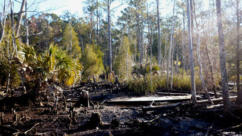 Destroyed boardwalk and mud along FNST near Spring Creek, by Barry Haber
The Florida Trail is one of America’s eleven National Scenic Trails and, it
seems, one of America’s
best kept secrets. In case you are among the unaware, the 1,300-mile Florida
National Scenic Trail (FNST) extends north from Big Cypress National Preserve
and through the Osceola National Forest, where it turns west and heads across
the Panhandle to Gulf Islands National Seashore.
On its way across the Panhandle,
the FNST passes through the Saint Marks National Wildlife Refuge. Within the
Refuge, the Trail crosses the headwaters of Spring Creek—an area of tidal ebb
and flow and, in spots, of crotch-deep black mud. With no dry land available,
the worst of the muddy places were spanned by boardwalks. Ten years ago, a
hurricane’s storm surge raised those boardwalks up and twisted them like
corkscrews. Eventually they became too dangerous to clamber over, they were
removed, and the Trail was closed—resulting in a 5.25-mile road-walk detour
around this highly scenic area.
The Florida Trail Association
(FTA) is among the finalists in a voting contest for a grant from the American
Hiking Society to replace those boardwalks and close this gap in the Trail. The
two trail projects with the most votes will each win $25,000. You can help FTA
win a grant by voting for the FNST every
day, through the end of October. Ask
your family, friends, neighbors, and club members (over age 21) to vote, and put
it out on your social media (facebook, twitter, etc.) too. Vote
today and vote every day!
|