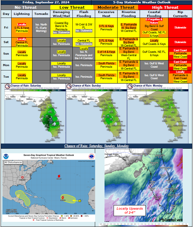
5 Day Statewide Weather Outlook for Fri. 9/27 to Tue. 10/1
Florida Division of Emergency Management sent this bulletin at 09/27/2024 03:23 PM EDT
This update is intended for government and emergency response officials, and is provided for informational and situational awareness purposes only. Forecast conditions are subject to change based on a variety of environmental factors. For additional information, or for any life safety concerns with an active weather event please contact your County Emergency Management or Public Safety Office or local National Weather Service forecast office.
You are subscribed to 5 Day Weather Outlook for Florida Division of Emergency Management. This information has recently been updated, and is now available.
...Breezy Conditions Linger in Wake of Major Hurricane Helene…Frontal Boundary Moving Southeastward Towards I-4 Corridor Bringing Additional Rainfall Across Peninsula Through Saturday…Marginal Risk for Flash Flooding Across Portions of West Coast and Central Florida Through Saturday…Dry Conditions Return Across Panhandle and Big Bend; Isolated Showers Return Next Week…Triple Digit Heat Index Values to Continue Throughout the Peninsula; Heat Advisories Likely Each Day for Portions of South Florida…Minor to Moderate River Flooding Forecast Along Eastern Panhandle and Big Bend Over Next Few Days…Minor Coastal Flooding to Continue Along Portions of Big Bend and West Coast Over Next Day or So…Hazardous Beach Conditions to Continue Statewide Through the Weekend...