
Traffic Impacts in Unincorporated Boulder County From Ironman Event
Boulder County Colorado sent this bulletin at 07/31/2015 04:14 PM MDT
Traffic Impacts in Unincorporated Boulder County During the IRONMAN Boulder Triathlon
The IRONMAN Boulder triathlon is being held Sunday, August 2, and will impact traffic in unincorporated Boulder County, including access to the Valhalla neighborhood, Boulder Reservoir, Coot Lake, the Boulder Model Airplane Park, the eastern Eagle Loop Trailhead and the N. 55th Street Trailhead.
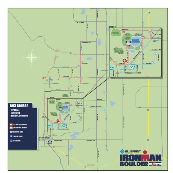
Boulder County, Colo. -- The second annual IRONMAN Boulder triathlon is being held this Sunday, August 2. Athletes competing in the IRONMAN Boulder triathlon will begin with a 2.4 mile swim at the Boulder Reservoir, followed by a multiple-loop 112 mile bike course through unincorporated Boulder County, and concludes with a 26.2 mile run in downtown Boulder. The IRONMAN Boulder triathlon is a timed competitive event, which will require several road closures and minor delays of traffic--including vehicles, pedestrians and recreational cyclists--as athletes pass through intersections.
The following areas will be closed or have restricted access during the bike portion of the competition:
Boulder Reservoir: Boulder Reservoir will be closed to public access all day Saturday, August 1, through noon on Sunday, August 2. Once the reservoir re-opens Sunday at noon, it can only be accessed from the north by utilizing N. 55th Street, until 5:30 p.m. All traffic leaving the reservoir should exit to the north until all road closures and traffic restrictions surrounding the reservoir have been lifted, which is scheduled to occur no later than 5:30 p.m.
Eagle Trailhead and N. 55th Street Trailhead: Access to the eastern Eagle and N. 55th Street trailheads will be closed from Saturday at 11:00 p.m. through Sunday at 10:00 a.m.
Boulder Model Airplane Park: Access to the Boulder Model Airplane Park will be closed Sunday, from 4:00 a.m. until 10:00 a.m.
Coot Lake: Coot Lake will be closed Saturday at 11:00 p.m. through Sunday at 4:00 p.m.
Valhalla Neighborhood: Residents of the Valhalla neighborhood, along with those who live within the road closure area, will be afforded access to their homes during the event. Residents are strongly encouraged to use N. 55th Street for both ingress and egress during the course of the event to minimize delays. Residents who approach from the south will only be able to access their homes through the checkpoint located at 47th Street on Jay Road and will experience longer wait times due to the volume of athletes on Jay Road.
Jay Road: Jay Road will be closed between the Diagonal Highway (Highway 119) and N. 47th Street from 4:00 a.m. until 5:30 p.m. on Sunday.
N. 55th Street / Monarch Road: Traffic south of Monarch Road on N. 55th Street will be closed from 4:00 a.m. until 10:00 a.m. on Sunday.
The following unincorporated county intersections may see delays between the noted times, as traffic is held to allow safe and unimpeded passage of athletes through these intersections:
- N. Foothills Highway (US 36) / Neva Road (7:00 a.m. until 1:00 p.m.)
- Niwot Road / N. 63rd Street (7:30 a.m. until 1:15 p.m.)
- Nelson Road / N. 63rd Street (7:30 a.m. until 1:30 p.m.)
- N. Foothills Highway (US 36) / Nelson Road (from 7:30 a.m. until 1:45 p.m.)
- N. Foothills Highway (US 36) / Ute Highway (CO 66) (from 7:30 a.m. until 1:00 p.m.)
- Ute Highway (CO 66) / N. 75th Street (from 7:45 a.m. until 2:30 p.m.)
- N. 75th Street / Hygiene Road (8:00 a.m. until 2:30 p.m.)
- N. 75th Street / Saint Vrain Road (8:00 a.m. until 2:30 p.m.)
- Saint Vrain Road / N. 65th Street (8:15 a.m. until 2:45 p.m.)
- N. 65th Street / Nelson Road (8:15 a.m. until 2:45 p.m.)
- Nelson Road / N. 75th Street (8:15 a.m. until 2:45 p.m.)
- N. 73rd Street / Niwot Road (8:30 a.m. until 3:00 p.m.)
- N. 71st Street / Niwot Road (8:30 a.m. until 3:00 p.m.)
- N. 71st Street / Monarch Road (8:30 a.m. until 3:15 p.m.)
- Monarch Road / N. 63rd Street (8:30 a.m. until 3:15 p.m.)
- Diagonal Highway (CO 119), Longmont-bound / Jay Road (10:00 a.m. until 4:00 p.m.)
- Diagonal Highway (CO 119) / N. 63rd Street (8:00 a.m. until 4:00 p.m.)
- Diagonal Highway (CO 119) / Mineral Road (CO 52) (10:30 a.m. until 4:00 p.m.)
- Mineral Road (CO 52) / N. 79th Street (10:30 a.m. until 4:15 p.m.)
- Mineral Road (CO 52) / N. 95th Street (10:30 a.m. until 4:15 p.m.)
- Mineral Road (CO 52) / N. 107th Street (US 287) (10:45 a.m. until 4:30 p.m.)
- N. 107th Street (US 287) / Lookout Road (10:45 a.m. until 4:30 p.m.)
- Lookout Road / N. 95th Street (10:45 a.m. until 4:30 p.m.)
- Lookout Road / N. 79th Street (10:45 a.m. until 4:30 p.m.)
- Lookout Road / N. 75th Street (10:45 a.m. until 4:30 p.m.)
- N. 75th Street / Jay Road (10:45 a.m. until 5:00 p.m.)
- Jay Road / N. 63rd Street (11:00 a.m. until 5:00 p.m.)
- Jay Road / Spine Road (11:00 a.m. until 5:00 p.m.)
- Jay Road / N. 57th Street (11:00 a.m. until 5:00 p.m.)
- Diagonal Highway (CO 119) / Independence Road (11:00 a.m. until 5:00 p.m.)
- Independence Road / N. 47th Street (11:00 a.m. until 5:15 p.m.)
The bike course will enter the City of Boulder at 28th Street and Jay Road and ends at Boulder High School. Traffic control in unincorporated Boulder County will be provided by deputies from the Sheriff's Office and troopers from the Colorado State Patrol.
A map of the bike course impacting unincorporated Boulder County roads is attached. For additional mapping or event information, visit IRONMAN Boulder.
#
/s/ Cmdr. Mike Wagner
Having trouble viewing this email? View it as a Web page.
![]()
|


