|
Monitoring Monday – Watershed Awareness
Join us Mondays as the Clean Water Team shares information and resources on watersheds and water quality monitoring. In preparation for Earth Week 2024 (April 22-26), let's take a look at watersheds.
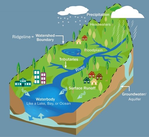
What is a watershed?
A watershed is an area of land that drains all the streams, rainfall, and snowmelt to creeks, streams, and rivers, and eventually to outflow points such as a point on a larger stream, rivers, reservoirs, bays, and the ocean.
The watershed consists of surface water--lakes, streams, reservoirs, and wetlands--and all the underlying groundwater. Larger watersheds contain many smaller watersheds. It all depends on the outflow point; all of the land that drains water to the outflow point is the watershed for that outflow location.
Watersheds can be as small as a footprint or large enough to encompass all the land that drains water into rivers that drain into San Francisco Bay, where it enters the Pacific Ocean.
The word "watershed" is sometimes used interchangeably with drainage basin or catchment. Watersheds consist of surface water--lakes, streams, reservoirs, and wetlands--and all the underlying groundwater. Ridges and hills that separate two watersheds are called the drainage divide.
Watersheds are important because the streamflow and the water quality of a river are affected by things, human-induced or not, happening in the land area "above" the river-outflow point. No matter where you are standing or sitting right now, you are in a watershed.
Watershed Videos
We All Live In A Watershed https://youtu.be/d-RsjIYNBkA?si=OMJbKb_wX-mCpykX
After the Storm- A Citizen's Guide to Understanding Stormwater https://youtu.be/WtZD173HfyE?si=21qEURTp8YnZ-b9R
Watershed Movie (extended trailer) https://youtu.be/5s6ne766cZI?si=htXvXi5s3l13GFxs
Watersheds 101 https://youtu.be/ofTdglXriug?si=2DbP1l6_Aya71cPt
|
California’s Watershed Management
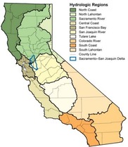
The State and Regional Water Boards are responsible for protecting California’s water resources. California is divided into nine regions based on major watersheds. The Regional Water Boards are located within these regions. For more than ten years the State and Regional Water Boards shifted their focus towards looking at entire watersheds when addressing water pollution. The Water Boards adopted the Watershed Management Initiative (WMI) to further their goals. With the input and involvement of local stakeholders, unique and effective solutions are created and the WMI provides an avenue in achieving water quality improvements.
Visit the Water Board’s Surface Water Ambient Monitoring Program (SWAMP), CWT “Community Based Watershed Programs” web page for further information about community-based watershed programs, volunteer monitoring programs, watershed groups in California, an inventory of watershed projects and more! https://www.waterboards.ca.gov/water_issues/programs/watershed/
Watershed Management Initiative (WMI)
The WMI was approved as part of the 1995 Strategic Plan and remains a part of the current Strategic Plan. The WMI establishes a broad framework overlying the numerous federal and state mandated priorities. As such, the WMI helps the Water Boards achieve water resource protection, enhancement and restoration while balancing economic and environmental impacts.
-
WMI Goals and Objectives The integrated approach of the WMI involves three main ideas:
- Use water quality to identify and prioritize water resource problems within individual watersheds. Involve stakeholders to develop solutions.
- Better coordinate point source and nonpoint source regulatory efforts. Establish working relationships between staff from different programs.
- Better coordinate local, state and federal activities and programs, especially those relating to regulations and funding, to assist local watershed groups.
-
WMI Charter
-
WMI Chapters The Regional Water Boards have developed watershed management strategies that consider local conditions and pollution sources for their priority watersheds. Each Regional Water Board’s WMI Chapter contains these strategies and identifies priorities, where baseline resources will be spent, and where more resources are needed. Each WMI chapter is updated as needed by the Regional Water Board or by a directive from the State Water Board. The combined Regional WMI Chapters comprise the Integrated Plan. To view a particular Regional Board chapter click on the link below:
-
RB 1 - North Coast Region
-
RB 2 - San Francisco Bay Region
-
RB 3 - Central Coast Region
-
RB 4 - Los Angeles Region
-
RB 5 - Central Valley Region
-
RB 6 - Lahontan Region
-
RB 7 - Colorado River Basin Region
-
RB 8 - Santa Ana Region
-
RB 9 - San Diego Region
California Watershed Information
-
State and Regional Water Boards Info and Map - https://www.waterboards.ca.gov/waterboards_map.html
-
Statewide Watershed Program - The California Secretary of the Natural Resources Agency requested that the former CALFED Bay-Delta Watershed Program make a transition to become a Statewide Watershed Program, to be administered by the Department of Conservation.
- The purpose of the Statewide Watershed Program is to advance sustainable watershed-based management of California’s natural resources through community-based strategies.
- The California Secretary of the Natural Resources Agency appointed a 24-member Statewide Watershed Advisory Committee consisting of two members representing each of the state’s ten hydrologic regions and four at-large members with a particular emphasis on tribal, environmental justice, and regional geographic focus.
- For information about the Statewide Watershed Program please visit the Department of Conservation’s Watershed Program Website.
-
California Watershed Portal - The Department of Conservation (DOC) is introducing the new California Watershed Portal, which began as a joint effort of the Natural Resources Agency and the California Environmental Protection Agency. The California Watershed Portal has been transferred to DOC’s Statewide Watershed Program, where it is being updated and redesigned.
-
Information Center for the Environment (ICE) - A cooperative effort of environmental scientists at the University of California, Davis and collaborators at over thirty private, state, federal, and international organizations interested in environmental protection.
-
Natural Resource Projects Inventory (NRPI) - A comprehensive, searchable, electronic database that houses information on thousands of conservation, mitigation and restoration projects being developed and implemented throughout California. NRPI contains an especially vast amount of information on water quality, watershed protection, fisheries habitat and exotic species removal.
-
California Watershed Assessment Manual (CWAM) - provides information and guidance to assist watershed assessors. The CWAM is a procedural guide that should be useful to a variety of watershed stakeholders. The mechanics for conducting a watershed assessment are described in detail in the CWAM. One of the ultimate goals of the CWAM is to provide some standardization among watershed assessments, to allow for cross-watershed comparisons.
-
California Watershed Network (CWN) - A non-profit organization formed in 2000, with the mission to help people protect and restore the natural environments of California’s watersheds while ensuring healthy and sustainable communities. CWN works to develop a coordinated network of community-based watershed management in California.
-
Joint Task Force on California Watershed Management - This Task Force assisted in the planning and execution of the State's Watershed Management plan. Included on this web site is the 2002 Final Report of the Task Force on the current status of watershed management in California and links to other valuable California watershed information.
My Water Quality
Visit California’s water quality portal Is My Watershed Healthy? To learn about The Healthy Watersheds Partnership. The Healthy Watersheds Partnership (HWP) is devoted to monitoring and assessing the conditions of California’s stream and river ecosystems and making that information available to the public, resource managers and decision makers. Our purpose is to support the protection of California’s healthy rivers, streams and lakes and the restoration of threatened and impaired watersheds. This is accomplished by providing and generating objective and unbiased science and technical resources centered on watershed process and function, aquatic ecosystem biodiversity, and integrated assessment data and information (See the HWP Assessment page for more details). The HWP is coordinating with the U.S.EPA’s Healthy Watershed Initiative, a nationwide effort to identify and protect healthy watersheds. https://www.mywaterquality.ca.gov/monitoring_council/healthy_watersheds/
|
Learn About Your Watershed
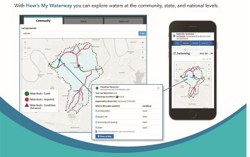
How's My Waterway
Use How’s My Waterway to learn about your water, explore data, and find out what’s happening in your community — anywhere, anytime. How’s My Waterway provides the public with an easily accessible and understandable picture of water quality at a community, state, or national scale. Map-centric and mobile-friendly, How’s My Waterway works on all different screen sizes ranging from desktop computers and tablets to mobile phones. https://mywaterway.epa.gov/
Community: Learn about the health of your waters, identified issues, why the issues matter, and what’s being done to restore or protect the waters. Find out more about your drinking water. Discover if waters in your community are suitable for swimming or eating fish and if they support aquatic life.
- Water quality in your local watershed.
- Information on swimming, eating fish and aquatic life.
- Restoration and protection efforts.
- Permitted discharger information.
- Identified Issues (impairments and discharge violations).
- Local drinking water information.
- Water monitoring information.
State: Choose a state to find basic facts about a state’s waters, summaries of specific water assessments, a statewide survey of water quality where available, and state drinking water metrics.
- Information about a state’s water program.
- Summaries of specific water assessments.
- A state-wide survey of water quality where available.
- State drinking water metrics.
National: Learn about the quality of water resources across the nation (lakes, rivers and treams, wetlands, and coastal areas) and the main challenges to our water resources nationwide. You will also find information about national drinking water quality and national drinking water metrics.
- The quality of water resources nationwide and their main challenges.
- National drinking water information and metrics.
Science in Your Watershed
Find scientific information organized on a watershed basis. This information, coupled with observations and measurements made by the watershed groups, provides a powerful foundation for characterizing, assessing, analyzing, and maintaining the status and health of a watershed. https://water.usgs.gov/wsc/index.html
-
Locate Your Watershed (Legacy 8-digit HUC) - use the mapping interface to locate the 2-digit region, 4-digit subregion, 6-digit accounting unit, and 8-digit cataloging unit and also link to additional watershed information from your cataloging unit.
-
Locate Your Stream Site by 12-digit HUC - use the mapping interface to locate your 2-digit region, 4-digit subregion, 6-digit basin, 8-digit subbasin, 10-digit watershed, and 12-digit subwatershed and also link to additional watershed information from your subwatershed.
-
Information Discovery - find projects, publications, and databases related to your watershed.
-
Data Integration - learn more about how you can use scientific data to understand your watershed.
Know Your Watershed
Know Your Watershed is a coordinated national effort to encourage the formation of local, voluntary watershed partnerships and help assure that these partnerships successfully attain their goals. The initiative is sponsored by more than 70 diverse National Partners representing private and public corporations, government agencies, and non-profit organizations. Each National Partner agrees to provide financial and/or in-kind support. The national effort is coordinated by the Conservation Technology Information Center (CTIC), a non-profit data and technology information transfer center. https://www.ctic.org/projects/Connecting_People/Know_Your_Watershed
CDC Watershed Maps and GIS Data https://www.conservation.ca.gov/cgs/fwg/maps
|
ADDITIONAL INFORMATIONAL RESOURCES
California Watershed Network: California Watershed Network (CWN) is a non-profit organization formed in 2000, with the mission to help people protect and restore the natural environments of California’s watersheds while ensuring healthy and sustainable communities. https://www.watershednetwork.org/
Caring for Our Watersheds: The Caring for Our Watersheds program asks students to submit a proposal that answers the question, “What can you do to improve your watershed?” Students must research their local watershed, identify an environmental concern and draft a written proposal containing one realistic solution. Community judges select the top entries to compete at a final, verbal competition for cash prizes. https://caringforourwatersheds.com/usa/california/
Center for Watershed Protection: The Center for Watershed Protection works to advance clean water resources and healthy ecosystems through responsible land and water management. https://cwp.org/
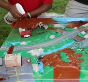
EnviroScape Watershed Model: The EnviroScape® environmental education models show water pollution and prevention through shared responsibility. A series of portable models dramatically demonstrate water pollution concepts and their prevention. EnviroScape® effectively communicates our shared responsibility for the environment to people of all ages, languages and cultures.https://www.enviroscapes.com/
USDA California Watershed Programs: Watersheds impact everyone; every community, farm, ranch, and forest. They provide a vital resource for all living things to survive and thrive. All watersheds are interconnected, creating a land-water system that conveys water to its final destination such as a river, lake, wetland, or estuary. https://www.nrcs.usda.gov/programs-initiatives/watershed-programs/california/watershed-programs-california
Water Education Foundation - California Watersheds: Our Vital Link https://www.watereducation.org/general-information/california-watersheds-our-vital-link
WikiWatershed Toolkit: WikiWatershed is a web toolkit designed to help citizens, conservation practitioners, municipal decision-makers, researchers, educators, and students advance knowledge and stewardship of fresh water. https://wikiwatershed.org/
|
|