|
|
CORRECTION: The upcoming Fire Safe Alliance Meeting is at , 6 p.m.,on March 20, not March 13 as stated in a previous version of this newsletter. We apologize for any inconvenience.


|
|
|
Featured story
By: Kevin Marini, UCCE Placer County
I’m beginning to schedule FREE presentations on “Firescaping” for 2025.
I’m your local Horticulture plant expert and Certified Arborist with 25 years experience running our local UC Master Gardener programs and teaching the community.
I’m providing FREE outreach and education through our local UCCE Placer County office on landscape defensible space (plants, shrubs and trees, not homes).
If you’re a Firewise community, a local civic organization, a real estate office, a school group, event planner or anyone interested in understanding how to manage landscapes for defensible space, feel free to reach out at krmarini@ucdavis.edu
I also do onsite consultations for Firewise community members for FREE so you’re equipped with information before executing potentially expensive work that may or may not be the best use of your precious funds!
This is especially important with tree work and timing of pruning, transplanting mature plants, and keeping plants from becoming hedged/sheared circle and square ember catchers.
|
|
By: Katie Low, UC ANR Fire Network Coordinator
Now more than ever, it is important for landowners and residents to consider how their home, gardens, and properties are vulnerable to wildfire.
Understanding how fires can approach a building is the first step in identifying your risks and prioritizing your actions.
Generally, structures are exposed to wildfire in three main ways: direct flame contact, embers, and radiant heat.
While distinguishing these mechanisms can help us prioritize our actions, keep in mind that they all happen at the same time, and they are all equally important issues to address.
Home hardening involves improving or maintaining building components such as roofs, gutters, and vents to reduce exposure to flames and embers.
Due to differences in type, year of construction, and location, it is difficult to generalize higher risks to residential buildings.
It is therefore crucial to identify the vulnerabilities of each building component so you can prioritize what needs to be done for your home.
The diagram below illustrates which building components are most likely to ignite during a wildfire.
When assessing your structures for wildfire preparedness, here are some things to consider:
- Are roofs and gutters clear of debris?
- Did you remove all combustible materials and vegetation within the first 5 ft of my home?
- Are fire-resistant vents installed, or are vents covered with a 1/8th inch mesh screen.
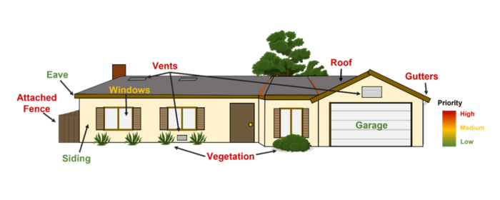 Figure 1: Common building components that are vulnerable to wildfires, color-coded by priority for home hardening actions (red being higher priority and green being lower).
It is also important to create defensible space by reducing vegetation and combustible materials around structures. Landowners can approach defensible space using a three-zone strategy.
Removing combustible materials from Zone 0, which is within 5 feet of structures, is the most critical part of a defensible space strategy.
Best practices include removing all vegetation and combustible material around structures, outbuildings, and attached decks or stairs.
When assessing Zone 0, consider:
- Is there a combustible gate or fence attached to the structure?
- Are there combustible materials like woodpiles or patio furniture next to structures?
Zone 1, which is 5 feet to 30 feet from structures, emphasizes well-spaced and well-maintained vegetation.
Considerations for Zone 1 include:
- Do I need to remove dead vegetation?
- Do I need to prune trees up to 6 to 10 feet from the ground?
Zone 2, which is 30 feet to 100 feet or more, aims to reduce flame heights of an approaching wildfire through well-spaced and well-maintained vegetation.
Considerations for Zone 2 include:
- Are trees or groups of trees separated by at least 10 feet?
- Do I need to remove any dead or dying vegetation?
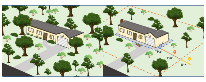 Figure 2: Interpretation of implementing a three-zone defensible space strategy.
To help residents of the Sierra Foothills interpret and apply defensible space strategies to their own properties, UCCE has created the Fire-Smart Landscaping Guide (https://ucanr.edu/sites/UCCE_Placer_Nevada/files/407444.pdf).
This free publication outlines key principles of defensible space and crucial elements of plant maintenance for fire resilience for common Sierra Foothill landscaping plants.
Interested in learning more about actions you can take to protect your structures and property from wildfire? The UC ANR Fire Network offers resources about wildfire preparedness on our website: https://ucanr.edu/sites/fire/Preparedness/.
Please reach out to Katie Low (katlow@ucanr.edu) with additional questions.
This free tool from UC Cooperative Extension and Placer OES is for Firewise Community members to digitally report their volunteer hours in real time using a computer, smartphone or tablet.
Community benefits:
Have questions? Let us know! Send us at email at katlow@ucanr.edu.
|
|
|
Placer County is dedicated to safeguarding our communities, forests, and critical infrastructure from wildfires. Here's a snapshot of ongoing and future initiatives aimed at enhancing public safety and preserving our natural landscapes.
🔥 Current Wildfire Protection Projects
-
French Meadows Ecological Forest Management: Evaluated 28,000 acres in the Middle Fork American River watershed, with 9,000 acres being treated on public and private lands to improve ecological resilience and reduce fire risk. The project is 80% complete on public land, with full completion expected next year, and 100% complete on private land.
-
Cabin Creek Fuel Reduction: 144 of 400 evaluated acres on county-owned properties identified for treatment, with completion expected in 2025. This initiative aims to reduce wildfire fuels and enhance forest health.
-
Yankee Jim’s Fuel Reduction: Targeted treatment of 41 acres of fuel reduction on USFS land near Sugar Pine Reservoir by 2025 to improve conditions, provide critical defensible space, and reduce fire spread risk.
-
County Vegetation Management: The Parks Division is managing vegetation on approximately 1,000 acres of county-owned properties. This work, supported by $3 million from the General Fund and additional grants, focuses on reducing fuels and maintaining healthy and resilient landscapes.
-
Community Fuel Breaks: The Placer Resource Conservation District (Placer RCD) is conducting multiple fuel break projects, including the 850-acre North Fork American River Shaded Fuel Break Phase II, currently 50% complete.
-
Green Waste Recycling & Chipper Program: Managed by Placer RCD and the Environmental Utilities Division, these programs help residents maintain defensible space and reduce wildfire fuels around their properties.
-
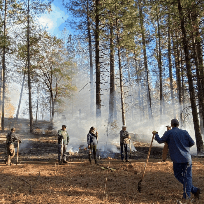
Prescribed Burning: Through the Placer Prescribed Burn Association, over 120 acres have been treated using controlled burns to manage vegetation and improve forest resilience. In collaboration with CAL FIRE and the Placer Resource Conservation District, these efforts support both public and private landowners by providing resources and expertise to safely reduce fuel loads, enhance ecosystem health, and build fire-adapted communities.
🌲 Planning for Future Treatment Activities
-
10-Year Wildfire & Forest Resilience Action Plan: The Regional Forest Health Division has evaluated 715,000 acres, identifying 22,000 acres for priority treatment. The county is actively seeking partners and funding to implement projects in these high-risk areas.
-
Foresthill Community Wildfire Protection: A planning project to identify and prioritize fuel reduction initiatives across 138,000 acres, focusing on protecting communities along the Foresthill Divide and surrounding watersheds.
-
Long Canyon Watershed Protection Project:
PCWA, in partnership with the U.S. Forest Service, will treat 6,200 acres in the Eldorado National Forest to reduce wildfire risk and improve forest health. The $1.4 million project includes thinning, reforestation, and prescribed burns, building on the success of the French Meadows Project.
-
I-80 & Highway 49 Fuel Reduction: Collaborative projects with CalTRANS, CAL FIRE, and local partners to reduce fire risks along critical transportation routes and protect evacuation corridors.
🚨 How You Can Prepare and Stay Informed
Join Firewise USA Communities:
Placer County leads the nation in Firewise USA communities. Get involved to create defensible space and enhance community safety.
For more information on ongoing efforts by Regional Forest Health and to stay connected, click here.
Together, we can strengthen our community’s resilience to wildfires and protect what matters most!
Foresthill Iowa Hill Fire Safe Council Meeting, 5:30 p.m., March 18 Information
Fire Safe Alliance Meeting, 6 p.m., March 20 Information
Greater Auburn Area Fire Safe Council Meeting, 9 a.m., March 21Information
North Auburn Ophir Fire Safe Council Meeting, 4 p.m., March 25 Information
Placer Sierra Fire Safe Council Meeting, 6 p.m., March 27 Information
In response to the Governor's Executive Order, N-18-25, The Board of Forestry and Fire Protection will be holding a public workshop to discuss changes to California’s Defensible Space regulations. AB 3074 (2020) directs the Board of Forestry and Fire Protection to establish a 0-5 foot, “ember resistant zone”.
The Zone 0 workshop will be held on March 4, 2025, 1-5 p.m., The California Natural Resources Agency, 715 P Street, Sacramento.
This workshop will have both an in-person and virtual option. Both in-person and virtual attendees are encouraged to let us know you will be in attendance by filling out this registration form.
|
|
|
|
|