Update from Kate
More High Tides Coming This Week
Expect Traffic Delays and Consider Alternate Routes
Please Share Widely:

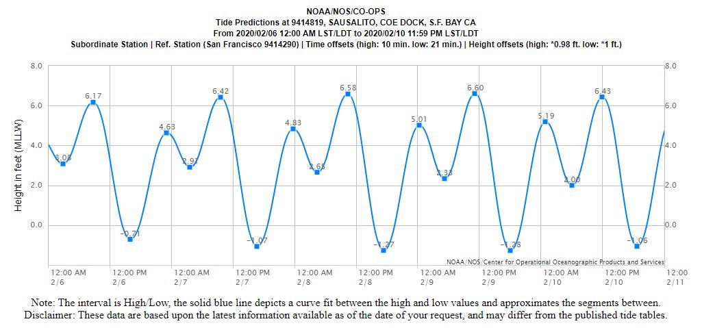 Above: Tide chart for Sausalito from February 6-10. Tides will be similar along the Mill Valley shoreline and in surrounding areas.
Do you live near or drive past the Manzanita Park & Ride, or know someone who does? Help us spread the word!
Based on tide predictions published by the National Oceanic and Atmospheric Administration (NOAA), tide levels February 6-10 are expected to be high enough to cause roadway flooding in parts of Marin, primarily coastal areas. Drivers are encouraged to consider using alternative routes and should allow extra time for trips, especially during peak commute times. Travelers should always avoid driving through ponded water, as even six inches of standing water can stall a low-clearance car.
Caltrans will display a real-time camera image of the Manzanita parking lot / signal so people can see what's happening in that area before deciding what route to take. To see the video, visit http://quickmap.dot.ca.gov/. Click the QuickMap "Options" menu and then check the box next to "Cameras." On the map, zoom into the Tam Valley area and click on the little blue video camera icon.
Travelers can also check 511.org for latest traffic and transit information. Marin County Department of Public Works (DPW) Twitter, Marin County Sheriff’s Office Twitter, the California Highway Patrol (CHP) traffic website and CHP Marin Twitter are excellent resources for travelers and residents looking for updates during storm events. Additionally, weather gauges showing rainfall and tide elevations can be viewed in real-time at Marin County’s OneRain webpage.
The following contains excerpts from a One Tam e-newsletter on January 8, 2020. To review the full text, click here.
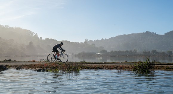 Above: Sausalito Mill Valley Multi-Use Trail along Bothin Marsh at high tide. Photo by Dana Lui, Marin County Parks.
The California King Tides Project helps us visualize future sea level by collecting images of our upcoming “king tides,” a non-scientific term we use to describe the exceptionally high tides that occur a few times each year. King tides occur when the moon and the sun align to create the most gravitational pull on the Earth’s oceans and when the moon and sun are closest to Earth. We have peak tides predicted locally in Mt. Tam's watershed at Bothin Marsh on February 8-9. Share your images of these high tides on social media with with #kingtides and #onetam, and with the California King Tides Project. Please be safe and take extra precautions when exploring the shoreline during high tides; also, be on the lookout for shore birds that may be taking refuge in the tideline and need extra space.
Learn more about the sea level rise challenges at Bothin Marsh where sea level is expected to rise ten inches in the next ten years, and learn how One Tam partners are preparing for sea level rise at Bothin Marsh and Bolinas Lagoon.
|