|
On Wednesday, January 22, the Transportation Commission will discuss design updates and safety improvements proposed for Aughinbaugh Way, Mecartney Road, and Maitland Drive as part of City's 2025 Pavement Program. This year the program will maintain and rehabilitate approximately 10.5 miles of roadway on the East End and Bay Farm as well as 1.5 miles of shared use trail along Island Drive and Mecartney Road. Full information is available in the staff report.
This bulletin includes:
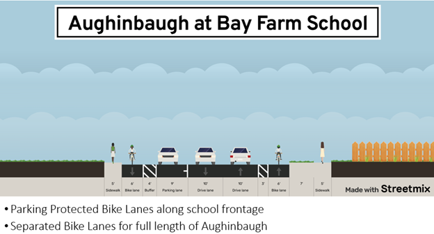
Aughinbaugh Way connects neighborhoods and provides access to Tillman Park, Bay Farm Elementary School, and trails along Shoreline Park. The Active Transportation Plan identifies Aughinbaugh for a separated bike lane. It is relatively easy to create a separated bike lane on this corridor because there are no residential driveways and no parking is allowed except immediately in front of the school. Proposed improvements include:
-
Manage speeds: reduce the vehicle lane width and increase the bike lane buffer width.
-
Create all-ages bike facility: Create a separated bicycle facility by installing vertical delineators within the existing bike lane buffer. In front of the school, create a parking-separated bike lane.
-
Improve pedestrian school access: Widen the western sidewalk to 10 feet between Robert Davey Jr. and the southern school entrance.
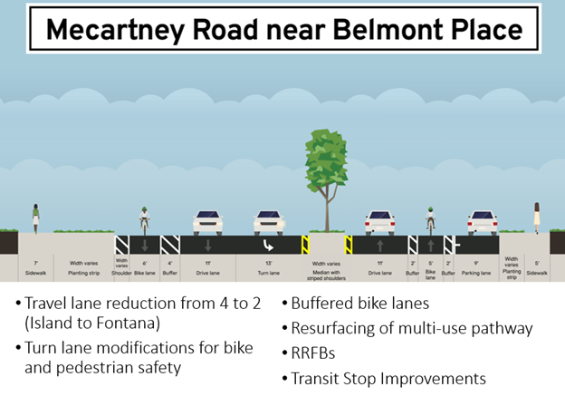
Mecartney Road is one of the primary east-west corridors on Bay Farm Island. As part of our Fatal Crash Response program, in early 2025 the City will install flashing beacons at the intersections with Mecartney and Marcuse Street, Fontana Drive, and Verdemar Drive. In addition to the flashing beacons, the Pavement Program proposes:
-
Manage speeds: Reducing the travel lane widths by striping adjacent to the median island and providing a buffered bike lane. In addition, reduce 4-travel lane section of roadway between Fontana Drive and County Road to 2 travel lanes.
-
Improve bicyclist access: Resurface the shared use trail on the north side and install buffered bike lanes in the roadway.
-
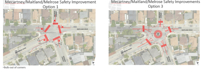
Make a safer intersection. Consider a modular roundabout at the Mecartney / Melrose / Maitland intersection to facilitate traffic, reduce vehicle speeds, improve visibility to motorists, improve pedestrian crossings, and reduce conflict points in this five-legged intersection.
Maitland Drive serves many residential properties and provides a connection to Harbor Bay Parkway and off-island access. The Active Transportation Plans calls for a bike route with sharrows. The proposed improvements will:
- Install bike sharrows along the entire corridor.
- Potentially relocate bus stops far side of intersections to improve transit rider visibility.
- Install new high visibility crosswalks at select locations.
On January 22, the Transportation Commission will hear the staff presentation, receive public comment, and discuss the design proposals. We hope you can join us or send your comments prior to the meeting!
Transportation Commission meeting, November 20, 6:30pm (agenda and staff report)
The 2025 Pavement Program will focus on the eastern third of the island, east of High Street and on Bay Farm Island. A map of all 2025 street selections is available as an attachment to the staff report.
Following street selection, staff reviews High Injury Corridor maps, Street Safety Concern reports, and Active Transportation Plan connections for pedestrian, bicycle, and vehicular improvements based on street type. While the 2025 Pavement Program will maintain additional streets, Aughinbaugh Way, Mecartney Rd, and Maitland Dr were the streets identified for additional enhancements to reduce vehicle speeds and enhance multimodal safety. The portions of those streets included in the 2025 Pavement Program are shown below.
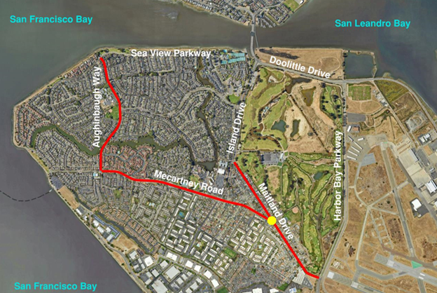 Portions of Auginbaugh, Mecartney, and Maitland in the 2025 Pavement Program
The City of Alameda has 128 centerline miles of public roadway providing access to all properties and businesses on the island. Maintaining the roadway network is central to the livability and economic vitality of the island. The City’s pavement management program consists of a mixture of preventive maintenance and rehabilitation. As part of Public Works' three-year paving plan, the City is divided into thirds and projects rotate throughout through these sections.
Wondering how streets are chosen for resurfacing, or want to learn more about the program? Watch the September 2024 staff presentation about City’s overall pavement management program, including how streets are selected, considerations for pavement treatment types, and the current status of Alameda roadways compared to the region. The presentation starts at hour 1:29.
Contact us
transportation@alamedaca.gov
www.alamedaca.gov/fernside
Your Measure BB Transportation Sales Tax dollars keep transportation going in Alameda!
You are receiving this because you are signed up for a transportation-related City of Alameda mailing list.
|