Wednesday, January 17th, 2024 @ 8:55 AM MST by Malloy, J.
Weather Pattern Shakeup by the Weekend...
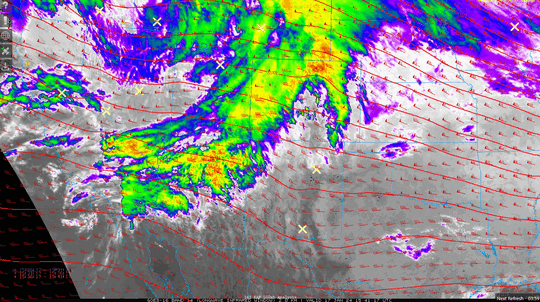
High pressure present in the southwestern U.S. continues to be a main catalyst for unseasonably warm and dry weather rest of the week. Satellite imagery this morning reveals a weather disturbance passing through the central Rockies today with an attendant band of high cloud cover set to enter the Desert Southwest. The brief cloud cover and a temporarily weakening of high pressure’s grip halts the warming trend today but does not reverse it. High pressure ridging is quick to strengthen Thursday-Friday leading to afternoon temperatures as warm as the mid-70s for places like Phoenix and Gila Bend. During Friday, abundant mid and upper-level moisture start to spill into the region from the Pacific as the large-scale weather pattern begins evolving towards troughing and unsettled weather in general by the Saturday-Sunday timeframe. Measurable rainfall is possible Sunday-Monday in the lower deserts with ensemble mean model guidance projections favoring light amounts at this time (less than 0.25”-0.33”). We’ll be monitoring trends, so stay tuned...
Normal High 68˚F (Record Warmest 83˚F in 1976; Record Coolest 47°F in 1960)
Normal Low 46˚F (Record Warmest 58˚F in 1993; Record Coolest 26°F in 1964)
Daily Record Precipitation (1.07” in 1933)
Today’s Sunset – 5:45 PM
Daylight Hours - 10hrs 13 mins
Thursday's Sunrise – 7:31 AM
Moon Phase – Waxing Crescent (43%)
Weather Tutor
Do cloudy skies influence surface winds? Yes, they can! A source of local wind variability in complex terrain is the uneven heating of valleys and mountains throughout the daytime hours as the sun progresses across the sky. Exposed surfaces and changing mountain aspects facing the sun warm to create localized rising motion (low pressure). Air tends to flow from high to low pressure. The air movement seeking environmental equilibrium is what we observe as wind. Differential heating over the course of a day can be a strong driver of mountain-valley wind circulations. Block the sun with passing cloud cover and you lose or diminish that terrain differential heating responsible for tighter spatial pressure gradients, hence, weakening wind flow when thicker clouds are present. A caveat to this discussion is when regional pressure waves are in play, such as a passing cold front (wet or dry). Such unsettled synoptic scale atmospheric features tend to temporarily override any predominate local mountain-valley wind circulation patterns typical under otherwise fair weather conditions.
Flood Control District | 2801 West Durango Street | 602.506.1501