|
|
Wednesday, December 27th, 2023 @ 10:10 AM MST by Malloy, J.
Weather is quiet and dry for the local region and is expected to remain so the rest of the week. High pressure has now become the dominant synoptic feature over us and should lead to a daily 2-4 degree warming trend in both temp maxes and mins through Friday. That’ll bring afternoons (mornings) in Phoenix from the mid-60s (low 40s) today to the low 70s (mid-40s) to wrap up the workweek. The Pacific storm track dips further south into the Desert Southwest in the Sunday/Monday timeframe to replace the current high pressure ridge. Model guidance points to temperatures falling back to seasonable in the Valley. At this time, the incoming weather disturbance around the New Year holiday is projected to be weak and moisture starved. A light precipitation threat is still possible in AZ’s central and northern high country. We’ll keep an eye on the weather pattern evolution as the week progresses...
|
|
Precipitation by Forecast Zones
 Click for full table
|
|
ALERT Data Display
Get real-time rainfall, streamflow and weather information.
Click here
|
Forecast Zone Locator
Find your forecast zone on our interactive map.
Click here
|
Custom Products
Looking for custom products, maps, plans?
Click here
|
|
 |
|
Normal High 65˚F (Record Warmest 82˚F in 1980; Record Coolest 43°F in 1916)
Normal Low 44˚F (Record Warmest 57˚F in 1983; Record Coolest 24°F in 1911)
Daily Record Precipitation (1.05” in 1984)
|
 |
|
Today’s Sunset – 5:27 PM
Daylight Hours - 9hrs 57 mins
Thursday's Sunrise – 7:31 AM
Moon Phase – Waning Gibbous (99%)
|
|
|
Weather Tutor
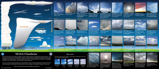 We’ll often point out expected sky conditions in our Weather Outlooks. You’ll hear discussion on whether “low”, “middle”, or “high” clouds may be seen in the upcoming forecast period. What does that mean? Concerning cloud classification, “low” clouds, such as fair weather cumulus or stratus, generally develop below 6,500 feet above ground. The “middle” clouds are found between around 6,500-20,000 feet and may include altocumulus formations that produce a “mackerel sky” appearance, which are fantastic for creating beautiful painted sunsets and sunrises. Lastly, “high” clouds (over ~20,000 feet) are home to the wispy cirrus cloud variety. During the advance of a dynamic and moist Pacific storm system, the typical progression of high, middle, and then low clouds is common as upper-level moisture tends to outpace near-surface moisture advection due to stronger winds aloft. There’s a lot more discussion we can have about cloud classification in future Weather Tutor sessions!
|
|
|
|