|
How to View the Final Tier 1 EIS/ROD
The public is invited to view the Final Tier 1 EIS/ROD by visiting the study website at azdot.gov/northsouthstudy. Hard copies are also available during normal business hours at the following repository locations:
• Eloy Santa Cruz Library, 1000 N. Main St., Eloy, AZ 85131 520.466.3814
• Coolidge Public Library, 160 W. Central Ave., Coolidge, AZ 85128 520.723.6030
• Florence Community Library, 778 N. Main St., Florence, AZ 85132 520.868.7500
• Apache Junction Public Library, 1177 N. Idaho Rd., Apache Junction, AZ 85119 480.474.8558
• Queen Creek Library, 21802 S. Ellsworth Rd., Queen Creek, AZ 85142 602.652.3000
What is Next for the North-South Corridor?
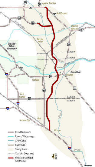
Subsequent Tier 2 environmental and engineering studies would need to be conducted as part of the NEPA process to further refine the selected 1,500-foot North-South Corridor to identify a recommended 400-foot freeway alignment and identify planned interchange locations and other project elements. The Final Tier 1 EIS includes a phased implementation plan with preliminary recommendations for how the North-South Corridor could move forward into Tier 2 studies. The phased implementation plan includes smaller segments of the selected corridor alternative that may advance as separate, independent projects. These studies, which are not yet fully funded, would include additional analysis and more opportunities for public review and comment.
ADOT is considering all funding options to move the North-South Corridor through the Tier 2 study process and eventually to construction.
More Information
For more information about the North-South Corridor Study or to view the project fact sheet, please visit azdot.gov/northsouthstudy.
Connect with Us
General comments or questions about the study can be submitted to ADOT through the following methods:
• Online: www.azdot.gov/northsouthstudy
• Email: northsouth@azdot.gov
• Phone: 1.855.712.8530
• Mail: c/o ADOT Communications – North-South Study,
1655 W. Jackson St., Mail Drop 126F, Phoenix, AZ 85007
The environmental review, consultation, and other actions required by applicable Federal environmental laws for this project are being, or have been, carried out by ADOT pursuant to 23 U.S.C. 327 and a Memorandum of Understanding dated April 16, 2019, and executed by FHWA and ADOT.
Pursuant to Title VI of the Civil Rights Act of 1964, the Americans with Disabilities Act (ADA) and other nondiscrimination laws and authorities, ADOT does not discriminate on the basis of race, color, national origin, sex, age, or disability. Persons who require a reasonable accommodation based on language or disability should contact Gaby Kemp, ADOT Community Relations, at 480.215.7178 or gkemp@azdot.gov. Requests should be made as early as possible to ensure the State has an opportunity to address the accommodation.
De acuerdo con El Título VI de la Ley de Derechos Civiles de 1964 y la Ley de Estadounidenses con Discapacidades (ADA por sus siglas en inglés), el Departamento de Transporte de Arizona (ADOT por sus siglas en inglés) no discrimina por raza, color, nacionalidad, o discapacidad. Personas que requieren asistencia (dentro de lo razonable) ya sea por el idioma o por discapacidad deben ponerse en contacto con la Gaby Kemp al 480.215.7178 o gkemp@azdot.gov. Las solicitudes deben hacerse lo más pronto posible para asegurar que el equipo encargado del proyecto tenga la oportunidad de hacer los arreglos necesarios.
|