|
Historic Highway closed east of Larch Mountain Road due to roadway settling.
March 13, 2025
For media inquiries: Ryan McCrary, 503-983-5506
For questions or comments: Dee Hidalgo, 971.352.5719
TROUTDALE – The Historic Columbia River Highway, also known as U.S. 30, is closed just east of Larch Mountain Road, between Portland Women’s Forum and Vista House.
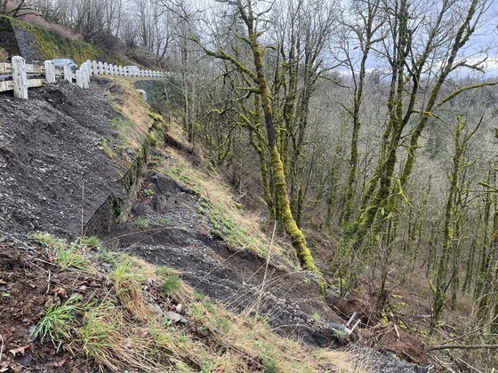
ODOT closed the road Wednesday evening due to recent roadway settling. ODOT monitors this section of the Historic Highway because it sits on an ancient landslide. Over the last decade, ODOT has repaved this section as cracks have appeared and the ground has settled. This month, geotechnical engineers noted that the settling has accelerated, and additional structural issues downslope have caused safety concerns.
With continuing rain and snow, significant settlement of guardrail, and continued ground movement the road will be closed to vehicles, bicyclists and pedestrians. The road is closed between milepost 8.7, where the Historic Highway and Larch Mountain Road split, and milepost 9.5, at Vista House.
Interstate 84 is the detour route for through users. Exit 22 Corbett Hill Road and exit 28 Bridal Veil remain open to access destinations along the Historic Highway.
Visitors to Vista House should use eastbound only exit 28 Bridal Veil and travel west on the Historic Highway. Drivers will no longer be able to access Vista House from Troutdale using the Historic Highway. Visitors to Portland Women's Forum should take exit 22 Corbett Hill Road to access the Forum.
Larch Mountain Road, Multnomah County’s highest road by elevation at more than 4,000 feet, remains closed for the season.
Please consult Tripcheck.com for the latest information on road conditions.
ODOT will work with geotechnical experts to determine how best to address this continued issue. We will share a timeframe for reopening once the assessment is complete.
History
The Larch Mountain landslide is a deep, massive landslide complex that occupies more than 100 acres of the Crown Point State Scenic Corridor. The Historic Highway skirts around the perimeter of this massive landslide; however, approximately 800 feet of the Historic Highway crosses an active section the landslide just east of the intersection with Larch Mountain Road, about a 1/2 mile west of Crown Point.
When the Historic Highway was built over 100 years ago, the ancient Larch Mountain Slide was a challenge. The original design for the highway at this location was a viaduct, or a bridge over land, though the structure could not accommodate the continuous movement of the landslide, and the viaduct was removed in the 1960s when ODOT built the current alignment. In 1983, and then again in 2007, ODOT constructed a retaining wall to support the Historic Highway. Continued ground movement, sometimes up to 12 inches in a year has required annual re-paving and reassessment.
|