Hi Montana State Library,
As we begin the new year, the Montana State Reference Network (MTSRN) is focused on expanding awareness and understanding of our state-owned network within Montana’s agriculture and farming community.
Over the past year, we’ve worked directly with producers across the state, providing hands-on opportunities to use the MTSRN in real-world precision agriculture applications. The results and the feedback have been both valuable and encouraging.
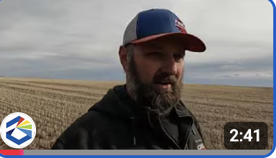
In the video below, producer Tony Fast of Fast Ag shares how he and his team are using the MTSRN to support their precision ag operations and improve efficiency in the field.
Through our partnership with the Montana State University Precision Agriculture Program, we’ve gathered valuable insights into how producers are using the MTSRN and the advantages it brings to their operations. You can download that use case study by clicking here.
What's new with the MTSRN Network
The MTSRN is excited to announce that the Montana Department of Transportation has committed to aggressively building stations to increase network coverage across our state. They hope to add 32 stations statewide by July 1, 2026. Several of these stations will be in Southeast Montana where additional coverage is being requested.
The MTSRN will work to secure funding to add those stations to the network as quickly as possible. While the MTSRN the currently the most robust real-time positioning network in Montana, these additions will only make our network that much better!
With the addition of seven new stations in 2025, MTSRN is now almost a fully GNSS (multi-satellite system) based network. 79 (out of 80) stations receive, and process GPS+GLN+GAL data and 39 stations receive and process GPS+GLN+GAL+BDS data. Implementation of NAD 83 (2011) MYCS3 early next year will make MTSRN aligned with NSRS and strengthen network's internal consistency to provide improved and consistent outputs to the users.
Did you know...
The MTSRN offers a free trial for interested users, giving producers the opportunity to gain hands-on experience with the network and see the difference it can make in their operations.
If you’re interested in signing up for a free trial available through the end of May, click here to visit our website.
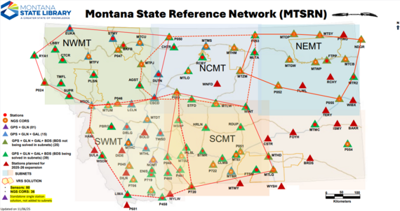 Our sensor map provides real-time status of all the stations operating on the MTSRN.
Montana State Reference Network (MTSRN) - Sensor Map
Contributors
The advancement of the MTSRN has been made possible by numerous contributors who host stations, demo our network to potential subscribers, promote the network through user testimonials, and educate our next generation on the use of MTSRN. We would like to thank all of them for their support of the MTSRN.
|