|
The Metro Council held its first meeting of 2026 on Thursday, January 8, 2026. This meeting, which is considered a special meeting is held to establish the leadership for the Metro Council for calendar year 2026. The election of a Metro Council President paves as well as Metro Council leadership paves the way for committees to be announced, chairs named and membership for each committee to be established.
During the meeting, Councilman Brent Ackerson was elected to serve a second year as Metro Council President. The vote for President in 2026 was 21-5. This strong showing of support was much different than last year when twelve Republicans and two Democrats joined together to elect Councilman Ackerson after numerous votes were taken over the course of the evening.
During an earlier meeting, representatives from the Majority and Minority Caucuses also elected their leadership for 2026. Democrats on the Metro Council elected Tammy Hawkins (District 1) and Jennifer Chappell (District 15) to serve as Chair and Vice Chair. Republicans on the Metro Council re-elected Councilman Anthony Piagentini (District19) and Khalil Batshon (District 25).
Committee announcements for leadership and membership for 2026 are expected to be made next week with committees starting to meet on Tuesday, January 20th. The next regular meeting of the Louisville Metro Council is scheduled for Thursday, January 29th at 6pm.
 Greetings,
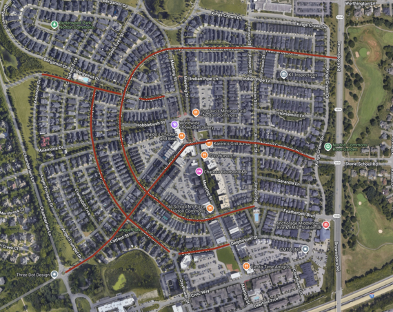
In the last budget cycle, I was able to secure $30,000 in funding for a sidewalk beveling project in Norton Commons. This funding was then matched by Norton Commons and Public Works to give us a combined $90,000 for sidewalk beveling. Beginning Monday, January 12th Precision Concrete will start beveling sidewalks on many streets in Norton Commons. The purpose of this project is to reduce tripping hazards and extend the life of sidewalks in the area. As your Councilman, I am committed to improving infrastructure throughout District 16.
This beveling project is a substantial start to the much-needed sidewalk and road repairs in Norton Commons. I look forward to working with Public Works during the upcoming budget season to secure funding for more extensive individual sidewalk repairs and road paving in Norton Commons. I want to especially thank Norton Commons, and Public Works for partnering with my office and contributing to this project. Partnerships like this help to maximize what we can accomplish with taxpayer dollars.
I will continue to provide updates in my E-Newsletter as my office receives them from Precision Concrete.
Please take a look at the attached map from Precision Concrete. The map shows the areas where beveling will occur.
It's an honor to serve,
Scott Reed
Councilman District 16
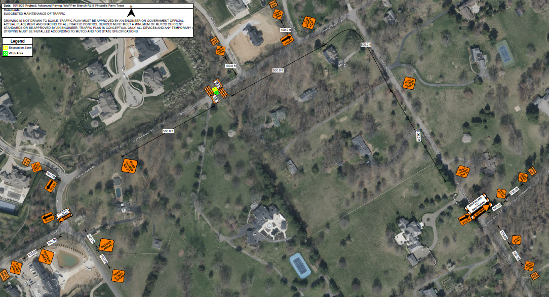 Advanced Paving and Construction Company has requested a road closure permit for Wolf Pen Branch Road to facilitate underground utility work associated with an MSD requested clean water diversion for a new subdivision development located at 7604 Wolf Pen Branch Road. The contractor has requested the permit for a one-month duration, from January 2 through February 2; however, the anticipated road closure is expected to last approximately one week, subject to weather conditions and bedrock constraints. Signage is expected to be installed during the week of January 5–9. The actual road closure is anticipated to occur from Tuesday, January 13 through Tuesday, January 20, depending on site conditions. Upon completion of the clean water diversion installation, Wolf Pen Branch Road will be reopened to through traffic. The contractor will likely request an additional road closure at a later date to install the sanitary sewer connections. Following the completion of all utility work, the roadway work area will be fully repaved, including the final surface course.
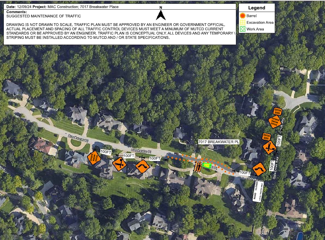 Louisville Water Company will be closing a portion of Breakwater Place, near 7016 Breakwater Place, to replace a 60-inch valve. The maintenance work is expected to start on January 11, 2026 and end on April 25, 2026.
LOUISVILLE, Ky. (Jan. 9, 2026) – The Kentucky Transportation Cabinet (KYTC) advises motorists of overnight lane and ramp closures on Interstate 264 East (Watterson Expressway) beginning Monday, Jan. 12, as part of the $130 million widening and improvement project of I-264 and U.S. 42 (Brownsboro Road).
Scheduled lane and ramp closures:
- Beginning Monday, Jan. 12, at 8 p.m., through Tuesday, Jan. 13, at 6 a.m., the off-ramp from I-264 East to KY 22 at Exit 22 will be closed. The ramp closure is necessary for contract crews to install a waterline.
- Beginning Tuesday, Jan. 13, at 8 p.m., through Wednesday, Jan. 14, at 6 a.m., the left lane of I-264 East will be closed between mile markers 23 and 22 (from the I-264/I-71 split to U.S. 42/Brownsboro Road). The lane closure is necessary for contract crews to deliver materials.
- Beginning Monday, Jan. 19, at 8 p.m., through Tuesday, Jan. 20, at 6 a.m., the off-ramp from I-264 East to KY 22 at Exit 22 will be closed. The ramp closure is necessary for contract crews to install a waterline.
Motorists should heed signage, use caution when traveling through the work zone, and plan ahead for travel delays.
The highway improvement project is expected to be completed by the Fall of 2027. More details, including project timelines and traffic impacts, will be shared online as work progresses. Motorists are encouraged to sign up for email or text alerts regarding weekly traffic impacts pertaining to the project.
For the latest traffic and travel updates across the Commonwealth of Kentucky, visit goky.ky.gov. Information specific to District 5 counties is also available on Facebook and X.
Contract crews to perform bridge work
LOUISVILLE, Ky. (Jan. 8, 2026) – The Kentucky Transportation Cabinet (KYTC) advises motorists of an overnight lane closure on I-64 East beginning Monday, Jan. 12, in Franklin County.
The left lane of I-64 East at mile point 53.15 (near U.S. 127) will be closed overnight from 7 p.m. Monday, Jan. 12, through 6 a.m. Tuesday, Jan. 13. The overnight lane closure is necessary for contract crews to perform bridge work. The work is part of the I-64 improvement project between the Frankfort exits (mile markers 53 and 58), which includes milling removing the existing asphalt surface followed by resurfacing with new asphalt pavement. Other improvements to the 5-mile corridor include bridge repairs and bridge crash wall repairs.
Construction is scheduled to be completed by the Fall of 2026. Motorists are advised to follow all lane closure restrictions, use caution when traveling through the work zone, and plan for additional travel time.
The date and duration of this work may be adjusted if inclement weather or other unforeseen delays occur. For the latest traffic and travel updates across the Commonwealth of Kentucky, visit goky.ky.gov. Information specific to District 5 counties is also available on Facebook and X.
| Jefferson County |
|
| I-65 Central Corridor |
Information related to the I-65 Central Corridor project can be found online at i65centralcorridor.com.
|
U.S. 31E (Main Street)
*Main Remade* |
*Construction phasing details, including traffic impacts, are available online at: www.MainRemade.com
Latest press release:
https://lnks.gd/2/33z8p--
|
| I-64 East and West |
Traffic Impacts: Traffic is in its final configuration. Lane closures are possible as final items as part of the project are underway.
Date/Time: Daily/nightly.
Project Limits: I-64 East and West at mile point 11.799, near Exit 10 (Cannons Lane) on I-64 West, and near Exit 12 to I-264 (Watterson Expressway) on I-64 East.
Type of Work: Bridge replacement project.
Other Details: *Project announcement press release
|
| I-65 South |
Traffic Impacts: Lane reduction and road closure.
Date/Time: Through Feb. 2026.
Project Limits: I-65 South bridge at Exit 136C to Jefferson Street in downtown Louisville.
Type of work: Bridge maintenance project.
Other Details: During construction, the bridge will be reduced to a single 10-foot lane. Wide loads will not be permitted to use the ramp, and signage will be posted in advance to alert drivers of the restriction. In addition, South Floyd Street will be closed between East Jefferson Street and East Liberty Street. Drivers should follow the signed detour: East Liberty Street to South Jackson Street, left onto East Jefferson Street, and back to Liberty Street. Motorists are encouraged to plan ahead, follow posted signage, and use caution when driving through the work zone. |
| I-65 South (John F. Kennedy Memorial Bridge) |
**Latest project update and details: https://lnks.gd/3/3RJ3qVj
-----------------------------------------------
* Temporary Kennedy Bridge Closure
- Beginning at 8 p.m. Friday, Jan. 9, and continuing through 10 a.m. Saturday, Jan. 10, all lanes of I-65 South will be closed just past Exit 1 to U.S. 31 South/Stansifer Avenue/10th Street in Jeffersonville, Indiana. Motorists should plan to detour by taking I-265 West to I-64 East to reconnect with I-65 South
-----------------------------------------------
Traffic Impacts: Closure of the right three lanes.
I-65 South (John F. Kennedy Memorial Bridge).
Type of Work: Expansion joint replacement project.
Other Details: The I-65 South to I-64 West ramp closure, which began Nov. 18, 2025, as part of the ongoing bridge expansion joint replacement project, will remain in place through January to support work on the southernmost expansion joint on the right side of the bridge. In addition to the ramp closure, the right three lanes and right shoulder of the Kennedy Bridge remain closed.
|
| I-65 North and I-264 East |
Traffic Impacts: Lane and ramp closures.
Date/Time: Friday, Jan. 16, at 7 p.m., through Sunday, Jan. 18, at 7 a.m.
Project Limits:
- The ramp from I-65 North to I-264 East will be closed.
- The ramp from KY 61 (Preston Highway) to I-264 East will be closed.
- The far right lane of I-65 North approaching the ramp to I-264 East, near the bridge over Standiford Lane (at mile point 130.04), will be closed.
Type of Work: Concrete slab repairs.
Other Details: These closures are necessary for contract crews to repair concrete slabs along the interstate and allow sufficient curing time. Motorists are urged to follow all lane and ramp closure restrictions, exercise caution in the work zone, and follow posted detour signage.
|
| I-264/U.S. 42 (Brownsboro Road) Improvement Project |
**Traffic impacts available here.**
|
| KY 841 North and South (Gene Snyder Freeway) |
Traffic Impacts: Single lane closures are possible.
Date/Time: Daily from 9 a.m. to 3 p.m., and nightly from 7 p.m. to 5 a.m.
Project Limits: KY 841 North and South (Gene Snyder Freeway), between mile point 35.0 and mile point 37.7, near and through the East End Tunnel.
Type of Work: Routine maintenance of the roadway and East End Tunnel.
Other Details: Motorists should heed signage, use caution, and adjust commutes to accommodate the lane closures. |
| KY 864 (Logan Street/Shelby Street) |
Traffic Impacts: Sidewalk and lane closures are possible.
Date/Time: Daily and nightly.
Project Limits: Between Goss Avenue and East Gray Street.
Type of Work: One-way to two-way conversion of the roadway.
Other Details: Major work has resumed, with full completion expected by Spring 2026.
*Project Webpage
|
| KY 1819 (Billtown Road) |
Traffic Impacts: Lane closures and delays are possible.
Date/Time: Daily – 9 a.m. to 4 p.m.
Project Limits: Three sections of KY 1819 (Billtown Road):
- Easum Road through Mary Dell Lane
- Michael Edward Drive through Fairground Road
- Shady Acres Lane through Colonnades Place
Type of Work: Reconstruction of KY 1819 (Billtown Road) from North of Colonnades Place to south of Easum Road with new traffic signals, signal optimization, turn lanes, storage lanes, etc. (varying by intersection based on existing conditions and future traffic projections).
Other Details: The reconstruction project is expected to be completed by the Spring of 2026.
*Project webpage
|
I-264
*Various Exit Ramps |
Traffic Impacts: Ramp narrowing with intermittent lane and shoulder closures.
Project Limits: Various interchange Exit ramps on I-64 and I-264.
Type of Work: Installation and upgrade of wrong-way pavement markings and signs.
Other Details: The Highway Safety Improvement Project will install and enhance wrong-way signs and pavement markings on interstate Exit ramps to discourage wrong-way driving. Motorists should reduce speeds and obey traffic control while workers are present. This project is expected to be completed by the Fall of 2025. |
| |
|
| Bullitt County |
|
| KY 1526 (Bells Mill Road) |
Traffic Impacts: Road closure.
Date/Time: Beginning Monday, Nov. 17, through May 14, 2026.
Project Limits: KY 1526 (Bells Mill Road) will be closed at mile point 14.35 at the bridge over Floyds Fork.
Type of Work: Superstructure replacement.
Detour:
- For westbound traffic on KY 1526 (Bells Mill Road): Turn left onto KY 61 (Preston Highway) south toward Shepherdsville. At the signalized intersection, turn left onto KY 44 (East 4th Street) to reach KY 1526 (Bells Mill Road).
- For eastbound traffic on KY 1526 (Bells Mill Road): Turn right onto KY 44 (East 4th Street) through Shepherdsville. At the signalized intersection of KY 61 (Preston Highway), turn right to then reach KY 1526 (Bells Mill Road).
|
| |
|
| Franklin County |
|
| KY 12 (Flat Creek Road) |
Traffic Impacts: N/A.
Date/Time: Beginning Aug. 11, through the Fall of 2026.
Project Limits: KY 12 bridge over Flat Creek at mile point 12.46 (at the Franklin/Henry County line).
Type of Work: Bridge replacement project.
Other Details: Traffic will be maintained on the existing bridge until construction has been completed on the replacement bridge. |
| I-64 East and West |
** The left lane of I-64 East at mile point 53.15 (near U.S. 127) will be closed overnight from 7 p.m. Monday, Jan. 12, through 6 a.m. Tuesday, Jan. 13. The overnight lane closure is necessary for contract crews to perform bridge work.**
Traffic Impacts: Lane closures and traffic shifts are possible.
Date/Time: Daily/nightly beginning Thursday, Sept. 4.
Project Limits: The I-64 East and West, between the Frankfort exits (mile markers 53 and 58).
Type of Work: The I-64 improvement project, between the Frankfort exits (mile markers 53 and 58), includes the milling and removal of the existing asphalt surface followed by resurfacing with new asphalt pavement. Other improvements to the 5-mile corridor include bridge repairs and bridge crash wall repairs.
Other Details:
- U.S. 60 (Versailles Road):
U.S. 60 (Versailles Road) will be reduced to one lane in each direction under the I-64 overpass bridge nightly from 9 p.m. to 6 a.m. beginning Monday, Sept. 15.
|
| U.S. 127/Vandalay Drive Intersection |
Traffic Impacts: Lane closures and traffic shifts are possible.
Date/Time: Daily/nightly.
Project Limits: U.S. 127/Vandalay Drive intersection.
Type of Work: The scope of the project includes constructing a new roundabout at the intersection of Vandalay Drive and Westridge Drive; extending Vandalay Drive to Limestone Drive to create a direct connection to KY 676 (East-West Connector); extending Vandalay Drive to U.S. 127 near the I-64/U.S. 127 interchange; and adding dual receiving lanes to improve left-turn movements from U.S. 127 onto Westridge Drive.
Other Details: The project is scheduled to be completed by the summer of 2026. |
| |
|
| Oldham County |
*Routine Maintenance* |
| |
|
| Spencer County |
*Routine maintenance* |
| |
|
| Shelby County |
|
| I-64 Widening and Improvement Project |
**Traffic impacts here.**
|
| I-64 West |
Traffic Impacts: Closure of the right lane.
Date/Time: From 9 a.m. to 10 a.m. on Monday, Jan. 12.
Project Limits: The right lane of I-64 West at mile marker 35 (near KY 53/Mt. Eden Road) will be closed
Type of Work: Guardrail repair.
Other Details: Motorists should heed signage, use caution, and expect travel delays. |
| |
|
| Henry County |
*Routine maintenance* |
| |
|
| Trimble County |
*Routine maintenance* |
| |
|
2025 Resurfacing Projects
Resurfacing projects will begin April 1, 2025, and
will be completed by the Fall of 2025.
Motorists should heed signage and use caution when traveling through the work zone.
| County / Road Name: |
Project Limits: |
| Jefferson County |
|
| U.S. 60 (Shelbyville Road) |
Begin at an asphalt joint west of U.S. 60A extending east to 53 ft west of Sherburn Ln Spur Conn/Ten Pin Ln, a distance of 01.85 miles |
| U.S. 60 (Shelbyville Road) |
Begin at Urton Lane/North English Station Road, extending east to an asphalt joint 0.038 miles west of Beckley Woods Drive/English State Way. |
U.S. 31 (West Main Street)
|
West Main St (US 31W southbound only) begins at US 150/West Main St, extending south to 145 ft north of US 31, a distance of 1.78 miles. |
| KY 907 (Valley Station Road/Third Street Road) |
Begin at U.S. 31E extending north to Arnoldtown Road, a distance of 3.99 miles |
| KY 1065 (Outer Loop) |
Begin at KY 907 extending east to a concrete joint at KY 1020, a distance of 02.48 miles |
| KY 61 (Preston Highway) |
Begin at the north end of the bridge over I-265 extending north to 0.026 miles south of Okolona Ter, a distance of 01.86 miles |
KY 1230 (Lower River Road)
|
From Tennis Blvd, west 0.093 miles, extending northerly to KY 1934, a distance of 2.62 miles. |
KY 2830 (Arthur Street)
*Completed* |
KY 2830 (Arthur Street) east of Brandies Avenue/KY 61 extending north to University Boulevard. |
U.S. 31E (Bardstown Road)
*Completed* |
U.S. 31E (Bardstown Road) at the Bullitt/Jefferson County line, extending south of Colonel Hancock Drive. |
KY 1631 (Crittenden Drive)
*Completed* |
KY 1631 (Crittenden Drive) at the beginning of state maintenance near the I-264 interchange, extending north to U.S. 60A (Eastern Parkway). |
KY 1531 (Johnson Road)
*Completed* |
KY 1531 (Johnson Road) from the railroad crossing extending north to Aiken Road. |
KY 61 (Arthur Street)
*Completed* |
KY 61 (Arthur Street) beginning east of Brandies Avenue extending north to I-65 ramp/East Gaulbert Avenue. |
KY 155 (Taylorsville Road)
*Completed* |
KY 155 (Taylorsville Road) beginning at KY 1747 (Hurstbourne Lane) extending north to KY 1932 (Breckenridge Lane). |
KY 329 (Covered Bridge Road)
*Completed* |
KY 329 (Covered Bridge Road) beginning at U.S. 42 extending east to the Jefferson/Oldham County line. |
| |
|
| Bullitt County |
|
KY 61 (Old Preston Highway)
|
Begin at KY 61 extending north to 0.165 miles north Hillsbrook Dr, a distance of 0.87 miles
|
KY 61 (North Preston Highway)
|
Begin 21 ft north of KY 2553 extending north to Bullitt/Jefferson County line, a distance of 01.58 miles
|
| KY 480 (Cedar Grove Road) |
Begin 0.113 miles east of Park Loop Rd/Valley Vw Dr extending east to 0.077 miles east of KY 1442, a distance of 0.42 miles |
KY 1442 (Ridge Road)
|
Ridge Rd/Clarks Ln from McCubbins Farm Ln, south 0.056 mile, extending easterly towards Paddock Rd, a distance of 4.90 miles. |
KY 1604 (Deatsville Road)
|
From KY 245, extending northerly towards Jackson Hollow Rd, a distance of 3.20 miles. |
KY 1531 (Dawson Hill Road)
*Completed* |
KY 1531 (Dawson Hill Road) from KY 1319 extending north to the Bullitt/Jefferson County line. |
KY 2672 (Knob Creek Road)
*Completed* |
KY 2672 (Knob Creek Road) from KY 1526 (Brooks Hill Road) extending north towards Lake Elmo Road. |
KY 2674 (Stringer Lane)
*Completed* |
KY 2674 (Stringer Lane) from U.S. 31E extending north to KY 44. |
| |
|
| Franklin County |
|
| U.S. 60 (Louisville Road) |
Begin at the east end of Benson Creek Bridge extending east to mile point .025 just east of Office Park Drive. |
| KY 12 (Dry Ridge Road/Flat Creek Road) |
KY 12 (Dry Ridge Road/Flat Creek Road) from the Shelby/Franklin County line extending east to Harvieland Road. |
| KY 1570 (St Johns Road) |
KY 1570 (St Johns Road) from the bridge at mile point 4.2, extending north to KY 12. |
| U.S. 127 (Wilkinson Boulevard) |
U.S. 127 (Wilkinson Boulevard) near Hall Street extending north to the south end of the U.S. 127/KY 2261 bridge. |
| |
|
| Oldham County |
|
| KY 53 (North First Avenue) |
Begin at KY 146 extending north to US 42 (MP 11.045), a distance of 03.99 miles |
KY 524 (Westport Road)
|
From US 42, extending northerly towards Smith Ln, a distance of 1 mile. |
KY 362 (Central Avenue)
*Completed* |
KY 362 (Central Avenue) from Rosswoods Drive extending south towards KY 146. |
KY 329 (Covered Bridge Road)
*Completed* |
KY 329 (Covered Bridge Road) from KY 329B extending east to mile point 8.754. |
| KY 393 (Crestwood to La Grange) |
Begin at KY 22 extending north to the south end of the North Fork Bridge, a distance of 1.99 miles |
KY 393 (Payton Lane)
|
From KY 1818, extending northerly to KY 22, a distance of 2.56 miles. |
KY 1694 (Gum Street)
*Completed* |
KY 1694 (Gum Street) from KY 329 extending north towards Mason Lane. |
KY 3223 (Old Sligo Road)
|
From KY 53, extending northerly to Ballard School Rd, a distance of 1.55 miles. |
U.S. 42
*Completed* |
U.S. 42 east of KY 1694 (Gum Street) extending east to the Oldham/Henry County line. |
| |
|
| Shelby County |
|
U.S.421 (Castle Highway)
|
Begin 21 feet north of KY 3322 extending north to KY 55, a distance of 2.82 miles. Castle Highway begins at Henry/Shelby County line extending north to the Shelby/Henry County line, a distance of 0.79 mile. |
KY 22 (Ballardsville Road)
|
Begin at Oldham/Henry County line extending east to KY 55, a distance of 7.02 miles |
KY 362 (Aiken Road)
*Completed* |
KY 362 (Aiken Road) from the Oldham/Shelby County line extending east near Webb Road. |
| U.S. 60 (Frankfort Road) |
U.S. 60 (Frankfort Road) beginning at KY 395 extending east to the Shelby/Franklin County line. |
KY 1408 (Floydsburg Road)
*Completed* |
KY 1408 (Loydsburg Road) from KY 362 extending west to the Shelby/Oldham County line. |
KY 322 (Lucas Road)
*Completed* |
KY 322 (Lucas Road) from KY 53 extending north to the Shelby/Henry County line. |
KY 53 (Mt. Eden Road)
*Completed* |
KY 53 (Mt. Eden Road) beginning at KY 714/KY 44 extending north to KY 1790 (Hooper Station Road). |
| |
|
| Spencer County |
|
KY 1392 (Grays Run Road)
*Completed* |
Begin at the east end of Simpsonville Creek Bridge extending east to KY 55, a distance of 2.64 miles |
KY 1633 (Elk Creek Road)
*Completed* |
KY 1633 (Elk Creek Road) from KY 1135 (Industrial Road) extending north to KY 55.
|
KY 1795 (Mill Road)
*Completed* |
KY 1795 (Mill Road) from Paradise Pointe Road extending east to KY 636. |
KY 55 (Shelbyville Road)
*Completed* |
KY 55 (Shelbyville Road) beginning at KY 155 extending north to the Spencer/Shelby County line. |
We now have a new way for you to map crime around you. Just click here and view our new interactive crime mapping tool for Division 5 & 8 or for each beat in Division 5 & 8. And save it in your favorites to view crime anytime it's updated daily. On the page is a Quickfind tool that allows you to put your address in and subscribe to crime trends, alerts and block watch reports for your police beat. Forward this email to your friends and family!
For further information on Councilman Scott Reed or District 16 please visit www.louisvilleky.gov/government/metro-council-district-16
You can also reach out directly by phone at 502.574.1116 or by email at scott.reed@louisvilleky.gov.
601 West Jefferson Street
Louisville, KY 40202
Having Trouble Viewing this eNewsletter? Click here to view it on the web.
|


